I took Friday the 26th off and did an overnight
trip into Upper Noisy Creek. This was a “burn” trip. In other words, I had
already been to this place, twice before actually. I call this a “burn” trip
because I had been here several times before and I could have used this time to
go somewhere else that I hadn’t been before which is becoming more important
for my project as access may begin to get harder due to road closures and I get
a year older every year. However, this year I wanted to make sure some of the
places I hope to get to would be snow free enough to look for fish and
amphibians so I decided to do this trip while I waited for a little more snow
to melt.
In my travels and noting amphibians, I have noticed a
curious pattern. I have never seen a Cascades frog (Rana cascadae) north of the Skagit River. South of the Skagit River,
starting at about 2000 feet elevation, they seem to be almost everywhere there
is a wetland or pond. North of the Skagit I have never seen any and I have
surveyed a lot of areas on all three forks of the Nooksack River and most of
the Baker River watershed. I don’t know the reason for this. Maybe I just haven’t
been in the right spots at the right time.
In about 2006, I went to a pond in a big wetland flat at
about 3700 feet on Upper Noisy Creek and saw a lot of salamanders. I also saw
some tadpoles. This would be about the right elevation for the Cascades frog
and I was aware of a number of reports of this species in the Baker River
watershed so I recorded them as Cascades frog tadpoles. Over the next few
years, I covered a lot of area on the Nooksack and Baker Rivers and didn’t turn
up any more Cascades frogs. So my hope in this trip was to go back into this
area and hopefully run into some adult frogs or at least capture some tadpoles
and get some really good photos that could be used for identification.
I went in via the Watson/Anderson Lakes trail (the sign now
says Anderson/Watson but we always said it the other way around). Just as you
are dropping into lower Watson Lake there is a way trail that takes off up the
hill to Upper Anderson Lakes. You can get onto the flanks of Mount Watson from
there and I walked the moraines below Mount Watson to a sharp ridge running
down into Noisy Creek. I went down near a creek that runs west of the ridge
into Noisy Creek.
There were a lot of sketchy spots along the route that I
didn’t remember from my trips here before. This sometimes happens. You tend to
forget the hard spots unless they are really difficult or really scary. These
spots were scary but not the heart-stopping kind of scary. I think I may have actually
taken a different route than I did before on this trip. This happens too. I
have noticed that, when I have been already been to a place, I tend to get a
little careless or sloppy in choosing a route. I made it work this time but, if
I ever went in again, I might spend a little more time looking for routes.
After 5 or 6 hours of walking, I made it to the flat and
spent several hours walking around and looking. This was the plan. My previous
trips had been day trips and my time to look around was limited. So I wanted to
do an overnighter to give myself a lot of time to look around and have a better
chance of seeing something.
It was basically a bust. There were lots of salamanders in
the pond again but there were no adult frogs. There weren’t even any tadpoles
this time. I did see two adult long-toed salamanders (Ambystoma macrodactylum). I had figured all of the larvae in the
pond were long-toed salamanders because there were no egg masses, large or
small, but there were lots of sticks that would probably have been used by
Northwestern salamanders (Ambystoma
gracile), if they had been present, to lay their large egg masses. The
adult long-toed salamanders made the case stronger for this being the species
present in the area.
The pond itself is a rather interesting feature. It is a
type of land form sometimes called a SAIL. SAIL is an acronym for Snow
Avalanche Impact Landform. These are usually found right against a valley wall
and are thought to be formed when a snow avalanche hits fine, soft soil in the
valley bottom with enough impact to excavate a crater.
The journey out was rather uneventful. I went down to lower
Watson Lake and caught a couple of fish. I ran into a lot of people on the main
trail. This is a pretty popular hike because you don’t have to go far to get
into some nice subalpine areas. In fact, you get some pretty spectacular views
without even leaving the road. I saw some older folks who looked like this hike
was about all they could do and I saw several families with kids 2 years old or
younger (I asked the one couple how old their child was).
The downside of this area being this accessible is that it
tends to get trashed but I think it is good to have areas like this that are
accessible to more of our citizens with a wide variety of skills and abilities
not just the most fit people with a lot of disposable time. I think it is worth
it because areas like this allow our less physically endowed citizens to still
experience the mountains and it provides excellent opportunities for future
generations of outdoor enthusiasts to get started.
The last time I was in here I ran into a guy who had been
making an attempt to climb either Mount Watson or Bacon Peak, I don’t remember
which. At some point in our conversation, this guy started bashing loggers. It
is about 45 minutes from the Baker Lake Highway to the Anderson/Watson Lakes
trailhead via a logging road. This road made it possible for him to drive up
from Seattle in a single day and do a climb. Without this road, it would have
taken him the better part of a day just to reach the the spot where trailhead
is now. This road also makes it possible for many of our citizens who otherwise
would not be able to, to access and experience the Anderson/Watson area.
There was a sign at the trailhead years ago that explained
how logging in the area (Silver Creek) helped finance the building and
maintenance of the Anderson/Watson Trail. I think this has been long forgotten by
many and I think the sign would no longer be politically correct. The U. S.
Forest Service is now considering closing a lot of roads because there are no
longer any funds to maintain them. It would be really unfortunate if the
Anderson/Watson Road and many others like it are closed.
Sunday my destination was a little pond at the head of
Grandy Creek. This pretty much turned out to be a bust as well. Much of the
land in this area is private and the road system is almost like a labyrinth.
So, rather than depend mostly on maps as I usually do, I also took an air photo
from Google Earth. Trouble is, I didn’t get a second one showing the ground a
little further east. I knew I was close to my target destination but without
the extra information that would have been on the extra air photo, I couldn’t
get my bearings from the features I was looking at on the ground. I knew better
than this. A lesson relearned. I did get to one small pond but I will have to
go back again, better prepared this time.
I did see a few interesting things. I saw a bobcat (Lynx rufus). I also saw some tadpoles
that were frog tadpoles which might be, and probably are, Cascades frogs north
of the Skagit River. There goes my little theory about no Cascades frogs north
of the Skagit River.
I also saw, or rather heard, some rock rabbits (Ochotona princeps) a.k.a. pikas in a log
pile in an old landing at about 2500 feet in elevation. I double checked to
make sure they were rock rabbits. I still call them rock rabbits because that
is what my dad called them and I like the colloquialism because it gives a nod
to common knowledge. Pikas are lagomorphs so they are related to hares and
rabbits. Another colloquialism, cony, is another name for a hare or a rabbit, as
well as being another common name I have heard used for pikas.
Pikas are thought by some people to be a high elevation
species and I have heard there is some concern how climate change will affect
them. I don’t know about that but I have observed these animals at quite low
elevations, the old limestone quarry at Lake Shannon above the town of Concrete,
elevation about 500 feet, the slope just above the Newhalem Creek Powerhouse,
elevation about 500 feet and many other places including the one this Sunday,
well below the forest line.
Overall I think this weekend was good for me. It helped
remind me that I need to take a little more care in my planning and I relearned
some important lessons at very little cost.
 |
| Mount Shuksan from U. S. Forest Service Road 1107 to Anderson/Watson trailhead. |
 |
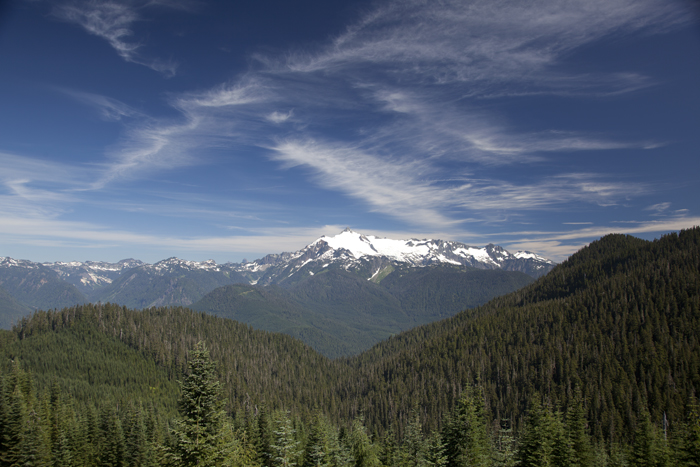
| Mount Baker from trail to Anderson and Watson Lakes. |
 |
| Watson Lakes from way trail to Upper Anderson Lakes. The tops of Mount Blum and Hagan Mountain are just visible over Noisy Creek ridge in the center of the frame. Part of Bacon Peak is on the right side of the frame. |
 |
| Looking up at clouds rolling over Mount Watson from the moraines below. |
 |
| Bacon Peak from the moraines on Mount Watson. I went down into Noisy Creek on the other side of the sharp ridge jutting up in the near distance near the center of the frame. |
 |
| The wetland flat on Upper Noisy Creek. The reddish pink patches are elephant head (Pedicularis groenlandica), a figwort (snapdragon family) that grows in middle elevation wetlands. |
 |
| Close up of elephant's head. A possible source for the pink elephants sometimes observed by drunken people? |
 |
| The pond that was my destination. This is the north end of the pond showing the avalanche track immediately above it. |
 |
| The pond and avalanche track. |
 |
| Looking south at the pond and wetland flat. Note the berm on the right side of the pond opposite the avalanche track. This is fine soil, probably deposited by Noisy Creek at some point in time, that has been pushed up by the force of avalanches hitting it, thus the term SAIL, Snow Avalanche Impact Landform. Also note that all of the logs are facing downhill towards the pond, an indication that avalanches are common here. |
 |
| Closer view of pond and berm. |
 |
| Long-toed salamander (Ambystoma macrodactylum) larva. |
 |
| Two more long-toed salamander larvae. The second one is slightly out of focus near the top of the frame. |
 |
| Lots and lots of long-toed salamander larvae. There are many more not so readily visible in the mesh of sticks around this log. There were so many salamander larvae in the pond I didn't even try to count them, estimating their numbers at hundreds or thousands. |
 |
| Adult long-toed salamander. This and another adult long-toed salamander were in some smaller ponds in the wetland flat. This photo is pretty blurry but the yellow dorsal stripe indicating this is a long-toed salamander is quite visible. |
 |
| Fish caught in Lower Watson Lake. I included my foot to give a sense of scale. The upper one was 10 inches long and the lower one was 12 inches long. Most of our high lakes don't have naturally occurring fish populations because waterfalls usually create barriers to fish migration into them. So most of the fish you see in high lakes have been stocked there by humans. |
 |
| Closer view of fish caught in Lower Watson Lake. The upper fish is a westslope cutthroat (Oncorhynchus clarki lewisi) or Montana blackspot as we called them when I was a kid. These fish are native to mountain lakes on the west slope of the Rocky Mountains and have been stocked in many of our high lakes. Note the deep red slashes under this fish's jaw. Also note that the black spots are larger and that there are very few below the lateral line which runs down the fish's side. Finally note that the maxillary or upper lip of this fish extends back past the eye socket. The lower fish is a rainbow trout (Oncorhynchus mykiss). Rainbow trout are the same species as steelhead only they remain in fresh water and don't go to sea. Note the black spots are finer and are quite thick below the lateral line. Also note that the maxillary doesn't extend back past the eye socket though it is hard to tell from this photo. Finally note the large red stripe down this fish's lateral line. This can be more pronounced or less pronounced than in this fish which is about average. The westslope cutthroat above also has a red stripe down it's lateral line but it is not as prominent. |
 |
| Twin Sisters above the South Fork of the Nooksack River viewed from a road system on private forest land. This road system is also part of the Pacific Northwest Trail. |
 |
| Mount Baker and Loomis Mountain from the same location as the previous photo. |
 |
| Loomis Mountain and Washington Monument from the same location as the previous two photos. |
 |
| The pond and wetland that I ended up going to. This pond is also at the head of Grandy Creek. It is just below a road intersection at a pass between Grandy Creek and the South Fork of the Nooksack River. The ground on the other side of the road from this pond breaks off pretty steeply into the Nooksack. |
 |
| Damselfly. One way to distinguish damselflies from dragonflies is that they hold their wings back against their bodies. Dragonflies always hold their wings straight out from their bodies. |
 |
| Dragonfly. There were several different sizes of dragonflies with several different color patterns at this pond. The largest ones were almost impossible to photograph because they didn't stay still for more than a split second at a time. I'm sure that eventually I could have gotten some pictures but I ran out of time. There a many different species of dragonflies and damselflies and I have occasionally been able to use photos to I.D. ones I have seen but I usually don't have time to do this. |
 |
| Water strider with red-orange head and back. I am also not very familiar with water striders. I thought the ones I saw at this pond were rather unusual because they had this red-orange coloration. I think I have seen water striders like this before but it seems the ones that I usually see are solid colors, dark brown to black. |
 |
| Commercially thinned private forest land. This stand of Pacific silver fir (Abies amabilis), western hemlock (Tsuga heterophylla) and red cedar (Thuja plicata) has been commercially thinned, that is a certain percentage of merchantable timber has been removed while the rest of the stand was left. |
 |
| Stand of trees nearby in same forest that has not been thinned. It is a little hard to tell the difference between this stand and the one pictured above from just photos but note that the tree spacing here is a little tighter and the understory is rather barren while in the picture above there is a vigorous growth of seedling trees and shrubs. |
 |
| Noble fir (Abies procera). Noble fir is a prized true fir species. Most of our other true firs are less valuable commercially. Noble fir doesn't occur naturally north of Stevens Pass with maybe a few exceptions. These noble firs have been planted back after logging. |
 |
| Noble fir has a distinct frosty look to it. This is from the stomata on the needles. Stomata are small openings through which the tree exchanges gases (oxygen, carbon dioxide, water vapor etc.) with the atmosphere. They appear as parallel white lines on the tree's needles and are especially obvious on new growth. Noble fir has two lines of stomata on the upper and lower surface of its needles. A true fir that is similar that occurs naturally in our area is subalpine fire (Abies lasiocarpa) which has one line of stomata on top of its needles and two lines below. The stomata on all of our other true firs are all on the bottom of the needle. |
 |
| Bobcat (Lynx rufus). This bobcat was on the road with its head down in the ditch, probably getting a drink. I didn't notice it until it lifted its head. It headed up into the woods immediately and I thought that was the last I had seen of it but I put my telephoto lens on just in case and, lo and behold, it was looking at me from behind this silver fir. I didn't even have to move to look for it. It remained looking at me for several minutes while I took some photos. |


Very cool pictures! Good observations.
ReplyDelete