|
The Sunday before last, I went for a walk up the Cow Heaven
trail.
Cow Heaven is so named because a man named Fred Trudell had
a contract with the U.S. Forest Service to graze cattle in the meadows there
back in the days when the Forest Service still did such things in this country.
Jack Mountain and the area around Monogram Lake were also leased for grazing.
This is why the trail to Monogram is steep and not well engineered in places.
It is literally a cow path.
Fred Trudell and my family were neighbors. They owned some
of the pastures along Corkindale Creek that one can see from Highway 20. Fred had
a trail into Cow Heaven from the back of those pastures. There is also a trail
that follows Rocky Creek into Cow Heaven as well as the more well known one that
heads off the Olson Creek Road near the Marblemount Ranger Station.
There is a lot of history here. Local groups of Skagit
Indians used to burn the Cow Heaven meadows to increase the berry crop and maybe game availability as well.
Evidently they did this for quite a while after European contact because my dad told me that his dad said that this was the practice in the old days. I
have heard from other sources that the meadows were not burned every year, only at certain times
and when conditions were right.
According to my family history, the last time this area
burned was in the mid to late 1920’s. I would like to say it was 1929 but I
can’t be sure of this. This last fire was caused by a campfire that two surveyors
let go on Jackman Creek on the north side of Cow Heaven. This fire burned over
the ridge, through the meadows and down to the valley bottom in places on the
Olson Creek side, across Diobsud Creek and all the way to Bacon Creek. This had
the same effect on the meadows as the Indian burnings and the berries and game,
especially bears were abundant there for years even up the time I was a kid.
The meadows are now heavily overgrown and the berries and game aren’t as
abundant.
Family lore also holds that Helen’s Buttes are named after
my grandma Helen because she used to go up there to pick berries. There is
another family living here that holds that the Buttes are named after their
Helen. I won’t argue that. The true origin of the name is probably lost to time. Besides that, the Skagits used this area first, probably for
hundreds, if not thousands of years. Undoubtedly it was a pretty important
place for them and I am sure they had their own name for it, which, as far
as I know, is lost.
A lot of people don’t know this but the Olson Creek Road
keeps going well beyond the present Cow Heaven trailhead. The road washed out the
Olson Creek Road bridge many years ago, before my time I think, and the Forest
Service didn’t repair the bridge. The Cow Heaven trailhead was next to the
creek where the road dead ended due to the wash out. In the late 1970’s some
people bought the property that the road runs through and began aggressively
trying to run people off claiming it was a private road even though there was
an established trailhead on Forest Service land on the other side of their property.
At some point, several private property owners later, access was finally cut
off to the trailhead. About ten years ago, volunteers built a new bottom
section from the current trailhead to reconnect to the trail.
I am named after an uncle who was killed in a logging
accident several miles up on the Olson Creek road. My dad helped replant the
units where my Uncle Pat and another uncle of mine logged.
This was my first good walk of the year and the start of
getting ready for the hiking season ahead. The last few years I have been
having trouble with leg cramps early in the year. Once I am in shape, they
don’t bother me much. This day my left ankle, which I have sprained a number of
times in the past, was also hurting. I walked to the point where my legs started cramping. This
was a little bit below the first snow. From there I walked up into where the
snow was beginning to get heavy. I figure it was a little over 3 miles, maybe 4, with a pretty heavy pack. My legs were stiff and sore for several days but my
ankle seems to be much better. It would be nice to stay in hiking shape year
round but other obligations in my life prevent me from having time to invest in
this.
The Forest Service sign at the trailhead says the lower half
mile of the trail (the new section) goes through a stand of old growth hemlock. In fact, most of the trail, including the lower half mile, goes through the 1920's burn and the forest there is not old growth at all. While it does meander through a few areas farther up that didn't burn in the 1920's, the majority of its length is in the burn. The trailhead sign is wrong or at least very inaccurate.
When I first learned about the forests around here an old-growth tree was considered to be at least three hundred years old. If there were a lot of these type trees in the forest, then it was an old growth forest. The definition of old growth forest has changed in the last twenty years or so to mean a forest that has trees of all different ages and sizes as well as a well developed shrub and forb layer. In other words, a multi-canopied forest or uneven aged forest. This was done to reflect to reflect the ecological function of a forest and has nothing to do with the age of the forest or of individual trees within the forest. The multiple layers create multiple niches for multiple different species, in theory, increasing biodiversity. Therefore, you can have a relatively young forest with a more open canopy that is uneven aged and more habitat niches and a relatively old forest with a more closed canopy and fewer habitat niches.
In the last several years, some people have been using terms
like “ancient forest” as synonyms for old growth forests. I think such terms
are designed to play on people’s emotions and are confusing while not providing
any real description of the forest. I like to call these terms “enviro-babble”.
When someone
describes another living person as “ancient” it is understood that this is a
metaphor and that person is not actually ancient. The way the term “ancient”
has been used in the context of forests and trees seems to be an attempt to be
literal rather than metaphorical.
West of the Cascade Mountains, before the fire suppression
of the 20th century, every 300-600 years, on average, most forest stands
experienced a stand replacement forest fire. This means that some part, often a
large part, of the forest was almost completely burned and replaced with a new stand
of trees that grew back from the ashes.
In human terms, ancient history ended 1500 years ago in
about A.D. 500. So, by human measurement, the lifespan of a 600 year old tree reaches only to
the end of the Middle Ages and a 300 to 500 year old tree doesn't extend out of the Current Era. While a 600 year old tree is very old compared to a
human, by the time it reaches this age, its days are numbered. Six hundred is also
very young compared to trees like bristlecone pines, many of which are truly
ancient in human terms. While certain individual trees in Northwest forests may
actually exceed 600 years old they don’t even come close to the 6000 years of
the bristlecones. If a tree can’t be considered ancient in human terms, how can
it be considered ancient by the standards of trees? Finally, consider 600 years is nothing compared to the age of these mountains and that, at 600 years per generation, almost 17 generations of trees have passed since glacial ice left the landscape here a barren pile of rock.
And, while certain individual trees in these forests may
exceed 600 years old, most don’t even come close due to mortality from natural
disturbances such as fire, disease, animal damage, floods and landslides. So it
would be wrong to describe individual old trees as “ancient” let alone an
entire forest around them that are made up of many trees that are much younger.
Forests on the west slopes of the Cascades are adapted to
large scale disturbances such as stand replacement fires. The forest along the Cow
Heaven trail is one very good example of a stand replacement fire though the ignition source was human caused rather than lightning which is the typical ignition source absent human activity. There are areas along the trail where
individual trees are hundreds of years old but much of this forest burned well
within the period of European American settlement. My grandparents and most of
my aunts and uncles saw it burn and, if one doesn’t believe what they said, the
evidence is there on the ground for anyone who knows what they are looking at.
Even though the last time this forest burned, it was not due
to natural causes, the effects and recovery are pretty much the same as if it
had started from a lightning strike.
If the reader will bear with me, I hope to show you what I am
talking about. I apologize for having been long winded on this post. It also contains
a lot of photos that may take a lot of time to load if you have a slow internet
connection. I don’t feel something as complex as a forest can be described by a
few photos, buzz words and slogans and I don’t really know how to break such a
description down into more manageable pieces.
 |
| Old growth Douglas-fir (Pseudotsuga menziesii). In the old days, this would have been called an old growth tree. Note the long, deep furrows in the very thick bark that give this tree its distinctive look. Some of the outer bark below the bend opposite me has flaked off over the years, creating a smoother look. The distinctive furrows are more obvious above my head. From my observations, the tree bark grows out enough to start creating the deep, long old growth furrows starting at around 100 to 120 years, depending on growing conditions. These deep furrows show up at the base of the tree first and as the tree grows, the deep furrows move further and further up the trunk. The tree pictured here is easily hundreds of years old. |
 |
| Second growth Douglas-fir. In the old days, this would have been called a second growth Douglas-fir. Note the bark furrows aren't as deep or long as in the previous photo. Also, the bark is not as thick but that is not readily evident in the photo. Finally the tree has a much smaller diameter and it is probably shorter as well, though I did not specifically check this out. This is in the 1920's burn so the living trees pictured here are about 80 to 90 years old. Note the Douglas-fir snag in the background. This is an old growth tree killed by the fire. I will be in a lot of the photos to give the viewer a sense of scale. |
 |
| Old growth western hemlock (Tsuga heterophylla). In the old days this would have been called an old growth tree. Note the bark is deeply furrowed. It is also thick, again this is not obvious in the photo. Note the distance between the furrows is less than in the Douglas-fir and the furrows appear to be shorter giving this species a different look than the Douglas-fir. This tree is also hundreds of years old, though it may not be as old as the old growth Douglas-fir previously pictured. Hemlock is not as long lived as Douglas-fir. Hemlock is also shade tolerant, in other words, it will germinate and grow in the shade of the forest, while Douglas-fir is not. So this tree may have seeded in many years after the Douglas-fir. |
 |
| Second growth hemlock. The two trees in the right and left foreground would have been called second growth hemlock in the old days. Note the trees are of a smaller diameter and the bark is not furrowed. The bark is also thinner. I am standing next to an old growth Douglas-fir snag that was killed by the fire. |
 |
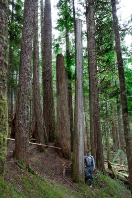
| This is near the bottom of the new trailhead on the Olson Creek Road. The large snag just behind me is a fire killed old growth western red cedar (Thuja plicata). There are two more fire killed red cedar snags in the background. The tree to my right is a second growth western red cedar that got established some time after the fire. |
 |
| This old growth red cedar snag is at the first stream crossing. We always called this stream Little Olson Creek. Much of the lower part of the trail runs near Little Olson and it crosses the creek three times. There is one Douglas-fir that may be an old growth survivor of the fire on the other side of the creek just downslope of this spot. |
 |
| Large second growth Douglas-fir and Douglas-fir snag. This photo was taken on the new section of trail just about where it connects with the old trail. The living tree and the snag may look close to the same size but quite a bit of the outside of the snag has fallen away, reducing its diameter. The fire that burned this area of the lower part of the trail might pre-date the 1920's or the growing conditions might be better here, resulting in bigger trees, or the date of the burn might have been misremembered by myself or someone before me. I counted the rings in a second growth windfall that had been cut out of the trail near here and came up with 60 rings before they became too obscured to count anymore with about a quarter to a third of the diameter to go. So the forest here might be a bit older. This is not unusual because there are lots of old burns and many overlap or are next to each other. At any rate, the forest here does not come close to predating settlement by European Americans. Except for the large Douglas-fir next to Little Olson Creek mentioned in the previous photo, there are no living old growth type trees along the lower part of the trail. |
 |
| Fire charred old growth Douglas-fir snag. |
 |
| Fire charred old growth Douglas-fir snag. |
 |
| Old growth Douglas-fir stump next to trail, just uphill on right hand side. Many, probably the majority, of the old Douglas-fir snags have deteriorated to this point. You can't really tell what killed this tree without doing some digging around in the stump. However, there are no living old growth type trees in this forest and there are lots and lots of these stumps and fire charred snags so it is safe to say that most were killed at about the same time by some large event- the fire. |
 |
| Fire charred old growth Douglas-fir snag. This tree may have actually survived the fire and died at a later date. |
 |
| Close up of previous photo. |
 |
| Sacha and Vashti at the one mile board. They had other things to do this day so they turned around at the one mile board. |
 |
| Fire charred old growth Douglas-fir snag above second crossing of Little Olson Creek. |
 |
| Fire charred red cedar snag just above the second crossing of Little Olson Creek. |
 |
| Short old growth Douglas-fir snag below trail, red cedar snag just above trail. |
 |
| First old growth Douglas-fir from bottom of hill. Note the large deep furrows in the bark running all the way up the trunk of the tree. Also note the large limbs fairly close to the ground. This could indicate that this tree initially grew in a fairly open spot. When trees are close together in a stand, as they grow, all the energy and resources of the tree are put into the upper foliage that gets more sunlight and produces more food. The trees quit putting resources into the lower branches that are shaded out and not producing much food. These branches subsequently die, causing a self pruning effect. When a tree grows in an open area, the lower branches are not shaded and continue to grow with the rest of the tree. Being in an open area may have saved this tree from the fire. There were probably not enough fuels to create an intense enough fire to burn through the bark and not enough ladder fuels to allow the fire to reach the tree's crown. |
 |
| Another old growth Douglas-fir fire survivor. This tree is just up the trail from the one previously pictured. Again note the large, low limbs though these are now dead. Also note the charred bark at the base of this tree. Douglas-fir is fire adapted. The bark of larger trees is thick enough to protect against lower intensity fires and the seedlings need the abundant sunlight in the open areas created by burns in order to grow. Douglas-fir is not shade tolerant and its seedlings will not grow in a heavily shaded forest understory. |
 |
| Three fire killed red cedar snags. Cedar is very rot resistant so these snags and logs are the most obvious remnants of many old burns. Douglas-fir is somewhat rot resistant and these snags and logs last for many years. Western hemlock is not very rot resistant and any snags and logs of this species killed in the burn have disappeared into the soil years ago. |
 |
| Just above the two mile at about 2000 feet in elevation (I'm not positive on the elevation because I couldn't find my altimeter before starting out on this trip) the trail drops into a big swale. This photo was taken just above the bottom of the swale. I am standing next to a cedar snag and there is a big fir snag just behind me. The second growth trees around me are western hemlock, Douglas-fir and Pacific silver fir (Abies amabilis). Just over my left shoulder in the far background is a live old growth cedar with a fire scar. |
 |
| This is the bottom of the swale. There are several larger live old growth red cedar trees behind me. The large snag is a Doulas-fir with a charred top. How this burned without getting the cedar right next to it is one of those little mysteries. The log next to me is also Douglas-fir and fell off the snag in the background. Several patches of old growth forest as well as individual trees in or near the swale survived the fire. I know very little about fire behavior but the swale is fairly wet as indicated by some large patches of Devil's club (Oplopanax horridus) and other plants. This may have made the area more humid and retarded the fire. The shape of the swale and how this caused air, sparks and cinders and other ignition sources to move in this spot may have affected fire behavior as well. |
 |
| Maybe a quarter of a mile and a few switchbacks above the bottom of the swale there is a large overhanging rock right next to the trail. One can see cut logs and some fire pits where people have camped. The opening under the rock is just out of view to my right in this photo. This is also one of the edge of the 1920's burn. The old growth Douglas-fir snag in the foreground was one of the last fire killed trees at this edge. |
 |
| This photo is on top of the rock shelter. To the left of the frame is the old growth forest that didn't burn in the 1920's. There is an old growth Douglas-fir near the center of the frame. Less obvious are an old growth western hemlock and red cedar a little further back in the frame. Note that the trees on the left side of the frame are all different ages and sizes. To the right of the frame is the 1920's burn. In the foreground on the right side of the frame is a fire killed old growth Douglas-fir snag. Note that, while there is some variation in size of the stand on the right side of the frame, all of the trees here are of a fairly uniform size. |
 |
| Looking downhill from the center of the previous photo. The old growth Douglas-fir on my left is the one noted in the previous frame. Again the old growth western hemlock and red cedar are visible but harder to discern (the hemlock is in the center of the frame and the cedar is to the right and a little further back). The hemlock and cedar are about 4 feet dbh (diameter at breast height). Notice the wide range of sizes of the trees in this frame. The largest is nearly 5 feet dbh while the smallest is about 6 inches dbh. This is because the trees are all different ages, thus an uneven aged stand of timber. |
 |
| Looking uphill 180 degrees from the previous photo into the 1920's burn. The small reddish brown double humped bump in the center of the frame is a Douglas-fir stump. The trees in this stand are all about 8 to 20 inches dbh. |
 |
| Looking uphill into the 1920's a few yards over from the previous photo. |
 |
| Old growth forest at about the three mile on the trail. The red cedar I have my back against and the one to the right of the frame are fairly small but they have very thick bark. Note that there are also snags in this photo. This is not uncommon. Trees all the time and create snags. These snags are probably Pacific silver fir that have died from causes other than fire. They have died individually or in small patches, not in huge swaths. There are no signs of fire present here. There are old growth trees like the one I am leaning against all through the stand and there are no fire scars or charred marks on them and there are no fire charred snags. The smaller trees are of a wide range of sizes, are not uniform and are not growing tightly together. The forest canopy here is more open, allowing more sunlight in which results in a well developed understory and a shrub and forb layer on the forest floor. |
 |
| Photo 180 degrees from previous photo. the tree to the right side of the frame is an old growth western hemlock. |
 |
| This photo was taken in 2011 looking northeast from the point where the trail breaks into the old meadows. The small white snags in the lower left of the frame are Alaska yellow cedar (Chamaecyparis nootkatensis) snags probably killed by the 1920's fire. The snags of this species are very rot resistant and persist for a very long time. Again I say these trees were killed by the fire because they didn't die individually or in small patches or clumps. It is evident that a large swath of them was killed at the same time from some large disturbance (the fire). |
 |
| Photo taken in 2011 looking south from Helen's Buttes back at the ridge where the previous photo was taken. If one looks closely, you can tell the trees in the low area on the left side of the ridge are different. These are likely trees that survived the 1920's fire. It is a little difficult to tell from this distance. At this elevation on these soils, the trees do not grow very tall so they are hard to distinguish from the second growth trees that haven't had their tops pruned by wind and snow yet. |
 |
| Photo taken in 2011 looking east from Helen's Buttes. This photo is just to the right of the previous photo. If one looks to the left center of the frame at the green ridge in the near distance, one can see that parts of the forest canopy look smooth while other parts of the forest look rough. The smooth parts are the 1920's burn where the trees are all of fairly uniform height creating an appearance of smoothness. The rough parts are old growth or mature forest where the trees are all different heights and small holes in the canopy where shorter trees are create shadows and a rough looking texture. The light yellow green in the old growth forests western red cedar foliage. Again, one edge of the burn is visible on the right side of the frame but very difficult to discern. The stream valley in the foreground is a tributary of Olson Creek. |
 |
| Photo taken in 2011 from Helen's Buttes looking southwest into the head of Corkindale Creek. You can just make out traces of the trail on the ridgeline. |
 |
| Textbook old growth forest. This photo was taken at about the 3 mile. There are many different sized trees ranging in age from hundreds of years old to seedlings in an uneven aged stand. This creates a multi-layered canopy and lots of habitat niches for lots of different species of organisms. This is a result of gap dynamics. Small to large gaps are created in a forest canopy over time creating openings where more sunlight can get to the forest floor. This can be caused by many things such as overstory trees dying of old age or disease or windfalls. Here there are several large windfalls behind camera. This created an opening and the small silver fir seedling in immediate foreground that was probably languishing in shade of understory began growing faster in response to increased light availability. The large Douglas-fir to my left in the photo points out another problem with trailhead sign. The signs says "old growth hemlock forest". This statement probably refers to the fact that the lower part of trail is in the "western hemlock zone". This type of forest classification is based on a climax forest. Climax forest classifications are based on the most abundant or dominant shade tolerant trees in an area. This is based at least partly on elevation. Shade tolerant trees can grow in the shade of their own species. In theory, over time, shade intolerant species like Douglas-fir will die out in these forests and be replaced by shade tolerant species like western hemlock. So after hundreds of years, a climax forest of mostly western hemlock and other few other shade tolerant species with no shade intolerant species. This almost never happens under natural circumstances. Douglas-fir is long lived and the forest is always reset by a fire or other disturbance before the Douglas-fir is completely gone. Quite a few Douglas-fir remain here in the old growth part of the forest and along the lower part of the trail where the 1920's burn happened, it is the dominant species in some areas. So nowhere that I observed along the trail is there a western hemlock climax forest. The area of this photo is probably in the Pacific silver fir zone which starts at 2000 feet elevation if my memory serves me correctly. |
 |
| Textbook second growth forest. This is just below 2000 ft swale, near the 2 mile. Note tight that this stand of trees is fairly uniform in size and height. Also note that there are no low limbs on any of trees because they have all been self pruned. Almost no sunlight reaches forest floor here so there are very few seedlings or smaller trees or shrubs or forbs. The forest floor is mostly covered by bare needles shed from the forest canopy and moss. Finally note the Douglas-fir snags on the left and right sides of the frame, an old growth log in foreground and a charred red cedar log behind me. Many of the second growth trees here are Douglas-fir. |
 |
| Second growth forest self thinning and beginning to open up due to gap dynamics. A second growth forest will also self thin. As all the trees grow, some can't keep pace and eventually get shaded out and die. The remaining trees continue to grow and the process continues until the largest trees can't shade each other out. At this point, or often before, disease, insect and animal damage and other things begin to kill individual trees or small clumps. This allows more sunlight into the forest and the establishment of more layers of mostly shade tolerant trees as explained previously. This process continues until the stand is replaced by some large scale disturbance like a forest fire as explained previously. |
 |
| Second growth forest self thinning. This spot is somewhere between the 2 mile and 1 mile if I remember correctly. This is a good example of gap dynamics and another forest canopy layer getting established. This looks like a fungal disease or maybe a small insect infestation killed a small patch of trees. The snags were smaller and rotted away rather quickly. |
 |
| This spot is near the bottom of the trail. Whatever caused this opening isn't readily obvious because it probably happened several decades ago or more. The snag to the right center of the frame is a fire killed old growth Douglas-fir. There is a layer of sapling trees and shrub and forb layers established here. The forest on the lower part of the trail seems to be a little more open than further up which leads me to believe it may be from a fire a little earlier than the 1920's though the forest here may look the way it does because growing conditions are different here. |
 |
| Naturally open area somewhere between the 1 and 2 mile. It can be tricky to tell what is happening here. This spot burned at the same time as the rest of the mountain side but poor, thin soil made it hard for trees to grow back. The trees here are much smaller than in other areas along trail because of poor growing conditions. The green vegetation along the trail is salal. I remember reading a speculation somewhere that salal might grow so densely that it inhibits tree growth. I think it is more likely that poor soil is what is inhibiting tree growth here. Salal is indicator of nitrogen poor soil. It, like many other members of its family (heath or Ericaceae which includes huckleberries, blueberries and rhododendrons to name a few) specializes in growing in poor soil and even on snags. It can live in these nitrogen poor spots because it has mutualistic relationship with mycorrhizal fungi that allows it to access nutrients not otherwise available to other plants. |
 |
| Red legged frog (Rana aurora). I understand red legged frogs are now listed as threatened or endangered in Oregon. They still seem to be plentiful here. I encounter them quite frequently at lower elevations and up to about 3000 feet. I saw this one near the bottom of the trail. |
 |
| Candy cane plant. I saw some of these along the trail in the 1920's burn. This vascular plant doesn't have chlorophyll and depends on a mutualistic relationship with fungi in the soil in order to live. The fungi bring water and nutrients to the plant. I have not read or heard anywhere if the fungi receive anything in return for feeding the plant. |
awesome - well done. enjoyed the virtual hike with you!
ReplyDeleteIm no expert, but I believe you just made an excellent point. You certainly fully understand what youre speaking about, and I can truly get behind that. Forestry Mulching
ReplyDeleteWondering if you know any other history here, Native American. There is an intense energy here and 2x my husband and I had to turn back, we are experienced hikers. Time felt strange and slow. Both times it happened at the 3 mile mark. It is a tough trail! This has only happen at 2 trails in the 12 years we have explored the Cascades, my favorite mountains. Thanks for the excellent info.
ReplyDelete