B.C. Trip Aug 2nd, 3rd
Had to be back to help out for salmon barbeque fundraiser at Community Hall on Sunday so took care of some chores and errands Friday morning before heading north. Turned down $640 in overtime on Saturday to do the trip. Camped out at Snass Creek trailhead. Saturday got up pretty early and headed just down road to Skagit River Trail between Highway 3 (Crowsnest) and Silver/Skagit Road. Wanted to scout it for several routes I planned to take later. Walked 8 or 9 kilometers (5 to 5 ½ miles or 10 to 11 miles round trip). Got back to rig a little after 1:00 p.m. Over an hour wait to get across border. Got back home at about 6:00 p.m. Sunday went early and took alder and helped set up hall. Did chores around house during middle of day and then helped clean up after barbeque. Was there until after 8:00 p.m. Some of the other folks were there later. Looked like we had mediocre showing. Bummer. This is the main fundraiser for hall for the year.
Clerf Lake, Klesilkwa River, B.C. Trip Aug 8th, 9th
Supposed to get rain on weekend and figured most, if not all, of route would be pretty brushy so decided to take Thursday the 8thoff and head in then when weather supposed to be good. Weather on Friday the 9thcalled for slight chance of thunderstorms and showers with better chance of rain on Saturday. Plan was to get into Clerf Lake with good weather on Thursday and play it by ear on Friday. Hoped to have good enough day Friday to get over ridge to west and small lake there. At least then would be able to see what the place looked like and if ended up getting wet, it would be on the way out. Nothing worse than getting soaked just to end up looking at a fog bank. Talked Andy Zitkovich into taking Thursday off as well and making trip with me. Both had Friday off because we were on new 4-10 schedule at work. Got good early start from Rockport at 7:00 a.m. Remembered everything except Canadian cash which I remembered that I had forgotten just a few miles from the border. Sky heavily overcast all the way from Rockport to Hope. At Hope sky showed few breaks in clouds and weak sunlight. About 10 kilometers up SilverSkagit Road there wasn’t a cloud in the sky. Was that way for pretty much the rest of the day. Got to road up upper Klesilkwa River at about 11:30 a.m. Parked on SilverSkagit Road and started out. I was packed for 3 days so pack was probably about 65 pounds, with heavy chunk of camera and wool coat that I still don’t feel comfortable without. Neck stiff and messed up. Slept on it wrong or maybe compressed gas bottles I had wrestled around the day before had caused it. Made pack feel kind of uncomfortable on my back but not unbearable. Bridge over fork of Silverhope Creek that drained south to Klesilkwa had been taken out a few years before so had to walk a quarter to half mile to area that had been logged in about 2014. Had been out here in about 2014 and been able to drive to this point at that time. Hadn’t seen a definite trail following grown over road up the Klesilkwa at that time but also hadn’t looked too hard. No obvious trail this time either. Followed flat area that looked like road grade behind a newer berm piled up at edge of logging unit. Looked like a faint trail over berm so figured it would be good enough. If this wasn’t road we wanted, we counted on being able to pick up road as we moved up Klesilkwa. Flat area became pretty brushy in a short distance. Thought we saw a grade a little higher on hillside and made for that. Sure enough, it was the grade. Faint trail on grade but couldn’t tell if it was made by humans or game. Soon came across a few newer flags and cut brush, evidence people had been in there within the last few years. Had read a report online about Clerf Lake a few years before that said something to the effect that it was a nice walk up an abandoned road or something to the effect that it was fairly easy. Wasn’t counting on that. From air photos from Google Earth looked like it might be pretty brushy at least in spots. And it was. Certain areas were pretty good walking where trees had grown tall enough on the road side to shade the road pretty well but other areas were choked with tag alders. Fortunately someone had been in there not too long before us and brushed out some of the thicker parts. Looked like a lot of the brushing was at least a year old but there was some fresh cut brush from this year as well. Weather was warm. Didn’t look at thermometer at that time but figured it was at least 80 to 85 degrees F. Looked at thermometer that evening when it was noticeably cooled and temp at that time was 75 degrees F. Remembered reading something on Environment Canada website that humidity would be about 80 percent. It felt like that wasn’t too far off. I was sweating profusely. Thanks to the brushing, going wasn’t too bad. Still pretty brushy but not nearly as bad as it could have been. We were able to move through spots in a few minutes that would have taken a quarter to half hour to navigate if they had been completely brushed in. Reached spot where brushed trail left road grade and cut up hill. At this point we could see ridge on east side of Clerf Lake not too far off. Hoped we were close. Followed flags up hill and soon ran into another grade. This was apparently the grade that I figured the trail would follow. Trail followed grade for short distance then took off from switchback that looked like the one I had been looking at on my maps. Had missed intersection with this upper grade in the brush below. Flagged trail now lead through second growth forest that looked like it had been logged 40 to 50 years before. Not to hard to follow but had to be careful or would have been easy to lose. Not end of world if this happened. Route pretty straightforward at that point but figured if we could stay on trail, someone else had already figured out a route and it would be easier. Trail finally led to avalanche track choked with tag alders. Could see big timber on other side about quarter mile away. Started in that direction. Nice gaps in tag alders at first but soon became solid thicket. Worked our way through brush slipping, falling, pushing through resisting limbs. Took about 45 minutes or so to get through this patch. Big timber on other side. Figured we were really close at this point. In valley of creek draining Clerf Lake and could hear it not too far away. Really tired. Had been looking at this route for years. Originally thought it would be pretty easy since road was so close but over years realized road had been abandoned for years so would be harder but probably still not quite mentally prepared for this trip and was more tired than I expected to be. Felt a little depressed and hopeless. Took break in timber. Another avalanche track not too far away on other side of timber. Andy suggested looking at maps and air photos to see if we could determine best route, hopefully avoiding most, it not all of tag alders. I was sweating so heavily that sweat had soaked through bandanna that I wore as a sweatband and into my hat to the point that sweat started dripping on maps as I was looking at them. Wrung out bandanna. This was the third time this day. I usually don’t generate enough sweat to have to wring out bandanna more that twice. Air photos showed another strip of timber and lake on other side of tag alder patch. Andy found pretty good route down close to creek. No more flagged route but game trail made by bears and moose, judging from tracks and scat. Started out again. Within a few minutes of working through brush, left thigh cramped in different set of muscles than I had experienced earlier in year. Surprised and disappointed. Figured that I was in good enough shape at this point that I should be able to push on even when legs very tired. Had to stop and rest and let cramp pass. Took a couple of leg cramp pills and waited it out. Right thigh started to cramp in same spot as left leg but this passed fairly quickly. Very depressing. This trip wasn’t that hard considering some of the places I would need to go in future in order to complete my project. Felt like giving up. Cramps passed in about 10 minutes and legs felt good enough to continue. Walked carefully from this point on. Move in wrong direction or getting leg hung up in brush at wrong angle could bring cramps back. Good route pretty close to creek. Brushy but not very thick. Also had game trail to follow. Moose and bear again. On other side of brushy area was patch of big timber on fairly steep slope, the final approach to Clerf Lake. Made it up last hill okay, no cramps and we were at lake. Time was about 3:30 p.m. Four hours, not too bad considering the brush. The overall distance we covered was probably less than five miles. Four hours to cover that distance on a good trail would be poor time. Clerf Lake is pretty spot. No good camping spots near outlet. Chest high oval-leaved blueberry or blue huckleberries as we always called them (Vaccinium ovalifolium) growing thick everywhere. Finally found spot to squeeze my tent in near outlet. Andy found spot a little farther out on east side of lake where he could lay his bivvy sack out on some big rocks. After setting up tent, tried working my way around east side of lake. Several large talus slopes there that would be pretty easy traveling to get to south side of lake and be able to look north directly down outlet. Had to get through several tag alder slopes first. Tag alders were growing on pretty steep slope. Hard traveling even though all I had was my camera. Finally gave up after about fifteen minutes and turned back. Large patch of timber on west side looked like much easier traveling. This was also just below the saddle we wanted to try to get through the next day to get to the small lake to the west and looked like the most likely route. Traveling was much easier on west side of lake, at least until I got to the brush patch there. At edge of timber had to get through another tag alder and willow patch to get to talus. From other side of lake it looked like if a person took an angle upslope, the distance to travel through the brush would be shorter. Tried this but brush seemed endless. After half an hour or more finally gave up. It was about 6:15 p.m. and sun had gone down behind the ridge. Figured it would be cutting it close to push on through brush and then back through it and get back before dark. Got back to timber at about 6:45 or 7:00. Was able to scope out a better route to saddle to west now that sun had gone down. Looked like the best thing was to follow edge of timber up higher. Would still have to get through small finger of brush but, once through, should be able to follow timber up above the larger brush patch. Headed back to camp and took a bunch of photos of Klesilkwa Mountain at the head of the lake and the unnamed (as far as I know) knob to the east of Klesilkwa Mountain. Fished a little bit and caught one, a rainbow trout, which I had kind of expected. Lots of fish in lake and probably could have caught several more but I needed to take care of other things before it got dark. Cooked and ate dinner and turned in. It might take a little extra time to get through the brush but we should have plenty of time. Looked like at least a few people came into Clerf Lake every year. There had been fresh cut limbs along the way in and there were small bits of evidence of human presence around the lake, a few fire pits, a Monster Energy drink can and an old rubber raft that the woodland critters had torn apart. Woke up next morning and didn’t want to get out of sleeping bag. Pretty common occurrence with me. I’m not a morning person. Missed Sacha and the girls and had a few other hangups. Pretty common until I get going. Once I get going I’m usually okay. Crawled out of tent and found that we were socked in. The cloud ceiling was a couple hundred feet above the lake. That pretty much put an end to the attempt to get over the ridge, at least at this moment. The saddle we were looking at going through was an iffy proposition to start with. It looked pretty steep and was in a lot of steep ground covered with slick vegetation that would probably be even slicker with cloud drip. I didn’t really want to be wandering around in the fog in that stuff. A lot of time the cloud cover lifts and the weather forecast called for this day, Friday to be pretty decent with a slight chance of thunder storms, so maybe the clouds would lift. Andy showed up and we figured we would give it until 9:30 or 10:00 a.m. If the clouds hadn’t lifted by then, we would head out. Maybe we should have waited until later but it was supposed to rain the next day so it wasn’t an appealing prospect to me to wait all day and not get a chance at the other lake and then get soaked the next day on the way out. If I knew we would have a chance at the lake, I most likely would have tried it. We were already expecting to get rained on Saturday but we also expected to be able to see to navigate over the ridge on Friday. No change by 10:00 so we headed out. Stumbled on a large wet meadow on way out. Had come in a little above this spot on way in. Moose bed in meadow, or assumed it was a moose bed, was as big or bigger than my bull (cattle) makes in the pasture. Also saw smaller bed, deer, small moose, bear? Lots of moose tracks and bear scat. Small pool in meadow still had mud stirred up in it from last time bear or moose was wallowing in it. Hit timber on other side of meadow and were soon at edge of big avalanche track that we had struggled through on the way in. Found a better route around it (Andy’s idea). There was still timber on the opposite (east) side of the creek from the way we had come in (west side) so we crossed the creek and followed the timber down below the worst of the brush. Saw a couple of adult tailed frogs on way out. Always nice to get an amphibian observation in. It was a surprising short distance to get below the avalanche track on the east side of the creek. Apparently it was narrower at the bottom and we had hit it, actually followed the flagged trail, into a higher, wider part of it. We didn’t want to stay on the east side of the creek for too long because it looked like it got pretty steep and brushy and we would likely not have as nice a road grade to walk on. Crossed back over to west side and saw a number of old cut stumps so we knew we should be pretty close to flagged trail. Knew we were below it so took a slight uphill angle and kept our eyes peeled for flags. Even if we missed trail at this point, there was a large landslide that had come down last winter or spring that crossed the trail. This slide was large enough that it would be hard to miss so once we cut the slide we would be able to pick up the trail at that point because we had noted where we had come through it on the way in (a small silver fir that spanned the gulley several hundred feet above one of the road grades we had been following). We picked up the trail about fifteen minutes after crossing back over to the west side. From then on it was a matter of keeping track of where the ribbons were leading. Crossed back over the landslide without too much of an issue. Had a little trouble finding flags on other side but only for a few minutes. We knew where our markers were but the nearest flag was hard to see. Traveled back out without incident and arrived back at rig at about 2:00 p.m. Four hours which was a little surprising. I had expected to make a little better time on way out especially with the better route around the big avalanche track. We had stopped several times so maybe our stops were longer. Speculate on cramps, maybe I had gotten more dehydrated than I realized, wrung headband bandanna out three times which was unusual, maybe day hotter and more humid than I realized, maybe just getting old, although this was a pretty rapid decline from year before. Body performed quite well year before. Maybe stiff neck affected me more than I thought or the long drive before the hike. Maybe a combination of everything. Psychologically not quite prepared for difficulty of trip. Though if I take a good hard look at some previous years, there were some trips that kicked my ass when I was much younger (Bench Lake when I was 30 and Firn Lake a few years later, first time I had ever gotten cramps, as well as a few other rough hikes). It’s just harder to remember those trips than the ones that were successful and that kind of sets one up, expecting things to be easy with no pain or discomfort. In my experience, hikes are rarely, if ever, without at least a little discomfort.
Unnamed Lake below Klesilkwa Mountain, B.C. Aug 15th, 16th
Goal this weekend was lake that we weren’t able to get into from Clerf Lake week before. This small lake is west and a little north of Klesilkwa Mountain. Route was on Trans Canada Trail up Paleface Creek. Had been up this route the year before on a scouting trip. Expected to walk 5 to 6 miles to get to spot where outlet stream of lake crossed the Trans Canada Trail/Silverhope Forest Service Road and camp there. If I had time, would try to get into lake. Took Thursday off work to do trip again. Weather system in Alberta supposed to brush that part of B.C. with low clouds and chance of rain on Saturday. Wanted to see what the place looked like. Got pretty early start about 8:00 a.m. Delayed a bit, watching Bugs Bunny with the girls while their mom took a short run. A few short stops at the bank and then to border. Got across pretty quickly, only about 15 minute wait. Stopped in Chilliwack to get something to eat and got turned around a bit and spent about half an hour finding my way back. Got to Paleface Creek Forest Service Road at about 2:00 p.m., pretty good time so far. I expected to be walking several miles up the Paleface Road before catching a trail that connected it to the Silverhope Creek Forest Service Road. This road/trail system is part of the Trans Canada Trail and last year the Paleface Road wasn’t driveable. Without thinking, I started to pull in to park when I noticed that the road looked different from last year. It had been opened up and looked driveable. So I started driving up it. Sure enough, it was driveable with some pretty good waterbars but nothing I couldn’t get over. I found it open all the way up to the trail to Silverhope and even farther. It looked like they had built some new road beyond the existing road that I was familiar with the year before. This would make my life a little easier since I had planned to use this road/trail to access a lake and some ponds at the head of the Klesilkwa River, which sits roughly east of Klesilkwa Mountain and the trip I was doing that day. The head of the Klesilkwa is just over the ridge from the new road. Checked new road out Parked rig and got started at about 2:30 pm. Hard to hike after such a long drive, especially since last bit of it was pretty bouncy. Trail was in really good shape. Much of it had been brushed recently. Got to spot where I planned to camp at about 4:00 p.m. The Silverhope Road wasn’t driveable by large vehicles at this point. I did see tracks of trail bikes. This left me about 4 hours to get into the lake and back out that day but I decided not to try. This was a calculated risk. I wanted plenty of time to check the place out and check out the gap in the ridge that we had planned on trying from Clerf Lake to see if it as doable. The weather was nice and clear and the forecast for the next day called for a mix of sun and cloud. I just hoped the ceiling wouldn’t be so low that I wouldn’t be able to see anything. This way I would have plenty of time to check things out. There wasn’t a very good spot to camp in the area. The road was brushed in except where they had cleared for the trail. Spent over an hour trying to decide where to camp. Finally pitched tent in a wider spot on road and hung my food. Took short walk back up trail/road and then had dinner a little early. It didn’t occur to me until I had set up camp that I could have continued on up into the lake and camped there. It would have taken a little longer, but I still should have been there well before dark. I had expected to have to walk a bit farther and it had been set in my head that I would be camping down at the road/trail. By the time I figured this out I had already set up camp and it would be pushing it to break everything down and try to get in before dark. I decided to just turn in early and try to get a good early start in the morning. Turned in at about 7:00 p.m. It was still light out. Slept surprisingly well considering I was on a road bed. Small bump in just the right spot to keep hips a little lower than upper body. Woke up at about 5:30 a.m. Finally got out of sleeping bag at a little after 6:00 a.m. Figured that it would be a pretty easy day. Only had to go up a little less than 2000 feet. The slope looked fairly gradual, nothing super steep. I had thought about starting out near head of valley and gradually gaining elevation and sidehilling into lake but decided it would be a safer bet to follow road/trail to point where it crossed the stream flowing out of the lake and then following this stream up. This would give me a sure fire reference for where I was going. Figured I would have plenty of time to get into lake, check it out and maybe check out another route before heading home. Got started at about 7:30 and started up on south side of creek and immediately got into a welter of brush. Decided to cut up through a logging unit that was about 30 years old. Couldn’t see very well from brushy road but looked like the trees were big enough and tight enough together that traveling would be fairly easy underneath, maybe have to deal with thick, dead limbs. I was wrong on that count. Trees were pretty widely spaced and there was enough room between them for a healthy growth of brush, head high oval-leaved blueberry-one of the worst types of brush to deal with in my book. Growth pattern tends to trap and impede feet with every step you take. Fought my way to bigger timber near creek and started up. Still brushy here but better. Had to circumnavigate huge rock near top of logging unit. From the top of the logging unit it was about 50/50 brush and open ground. There were a lot more steep spots, quite often large rocks to navigate than I had expected but nothing that really worried me. Finally I could see what looked like an opening above. Maps showed a kind of flat on the south side of the creek and I figured that I was getting close to it. Sure enough, it was a flat with a wet meadow in it. Saw several salamanders in oxbow lake near a small stream that flowed toward the lake outlet stream that I had been following. Debated stopping and taking notes but finally decided to. Didn’t know if I would hit this flat on way back down. Cold, only in mid to upper 50’s Fahrenheit. Had been a mix of blue sky and heavy clouds when I had started out but now it was just solid clouds with no blue showing and a steady breeze that really cooled things down. On air photo looked like I was about half way into lake and it was only about 8:30 a.m. Of course the air photo I had was from Google Earth and some genius there had updated their photos a few years back with more recent photos, the only trouble was that in the new photos everything was covered with several feet of snow so it was a little difficult to tell exactly where I was. For navigation on the ground it would have been better to have the older photos that showed the vegetation and other features of the landscape more clearly. As nearly as I could tell, I was a little below what looked like a big talus slope under the snow. I could see a talus slope a little above me so I figured that was probably where I was. From the talus, the lake looked pretty close. Took notes on wetland and continued on, aiming for the talus slope. Immediately out of wetland, ran into another huge rock that I decided to navigate around in a direction away from the talus slope, planning to sidehill back in that direction once above the rock. Once I got above the rock found steep slope covered with heavy growth of white flowered rhododendron. White flowered rhododendron is a plant I have a complicated relationship with. Many times I have been glad to have it to hold onto in steep areas but it is also very difficult to move through and you have to be careful how you grab onto it because it is very brittle and can break off in your hand quite easily. It is also very slick underfoot. It isn’t too bad to go through downhill because it usually lays in the downhill direction. Of course this makes it twice as hard to move through in an uphill direction and even harder to sidehill through. There was no help for it but to struggle through it. Usually resorted to just going straight uphill, looking for spots where it wasn’t quite so thick and then try to sidehill in those spots. Fought through up and across slope for I don’t know how long. Hard to see, brush usually in my line of vision. Seemed like it was taking a long time to get to talus. Finally, as I was eyeing a route uphill through more rhododendron, happened to glance down and see talus a little below me about a hundred yards away. Made my way to it and found that it was the lower part of the slope that I had seen from the wet meadow below. Worked my way through talus. Could hear lake outlet stream not too far away on far side of talus. Figured I was pretty close at this point. From maps and air photos looked like I should be able to sidehill up just a short distance and be at lake. Again slope didn’t look too bad until I actually got to it. More white flowered rhododendron on a steep slope. Stumbled and floundered into it, trying to keep a course in the direction of the lake. After what seemed and eternity, finally got into some more open ground covered with heather. I knew I was right below lake at this point. One final stop to catch my breath and then the final push into the lake. It was about 10:00 a.m. when I got there. Two and a half hours-a little longer than I had expected. There was a steady wind blowing from the south and it chilled me almost immediately. Put on sweat shirt and wrung out bandanna which was soaked with sweat and turned into an instant swamp cooler in the breeze. Disappointed to see that ceiling was pretty low. Could see surroundings of most of lake except for Klesilkwa Mountain which was mostly hidden in the clouds. Oh well, took the gamble yesterday that I would be able to see more today. Checked lake out and small pond just below outlet. Lots of salamanders there, probably long-toed salamanders. Lake was a sky blue-green color like it had a bunch on glacial flour in it. Interesting to me because there weren’t any glaciers on the maps and I couldn’t see one on Klesilkwa Mountain, just some snowfields. Wanted to check out gap that Andy and I had considered trying the week before in order to try to get to this lake. Could see it and it wasn’t too far away. Route to it took me past inlet stream on east side of lake. Found the inlet stream was carrying a lot of color in it. Followed it up a short distance and saw its source, a good sized snowfield. Maybe this had been a glacier at one time but now it was an average sized snowfield. Continued around to try to find the gap from the Clerf Lake. Pretty cool to look down into Clerf Lake where we had camped the week before. Finally found the gap and it looked like an effort the previous week would have been a wasted effort. It looked like it dropped off sheer for at least a hundred feet at this spot. Found a big crack in the rock that looked like it headed down into the cirque above Clerf Lake but didn’t follow it. Looked like it led partway through the cliff but then dropped off sharply. It would have taken a little more effort to explore this area and it looked like I would just end up at the edge of another cliff, albeit a little lower than the one I was standing on. I didn’t need to get into Clerf Lake so called it good at that and headed back. Saw a bunch of whitebark pine up on the ridge. Seemed like a lot of them were in pretty good shape. There were some snags here and there and there was one that looked like it was being killed by blister rust but everything else looked pretty healthy. Got back to spot where I left my pack at about 1:00 p.m. I had been poking around for about 2 hours. Tried fishing lake for 10 casts. No bites, no fish following bait in. Hadn’t seen any fish surface whole time I was there so figured no fish or at least they were laying low that day. Clouds cleared up off Klesilkwa Mountain so got some photos of that. Nice to get full view of mountain. Wasn’t too impressive from this angle and elevation but if sky had been different probably would have still been able to get some good, even striking photos of azure lake in foreground with mountain and interesting clouds in blue sky in background or even interesting dark clouds. As it was, sky was pretty much plain white slate. So it goes sometimes. Started out. Went down about 100 feet and stopped near small waterfall and had lunch before continuing on. Took route down pretty close to outlet stream. Plan was to keep to south side of stream or keep stream on my right hand. Same drill, lots of brush and steep ground and had to backtrack several times to get around giant rocks. Hit flat wet meadow and crossed a stream there. Didn’t click at that time that it was the outlet stream of lake. I thought outlet stream was farther north and thought it funny because the stream I crossed was pretty good sized to have just sprung from the ground. Could see talus to the south where I had come through earlier and took a few photos before continuing down. Lots of brush and steep ground with a few nice open patches of timber. Had to cross several tributary streams. Tried to cross these as soon as I realized they were there, otherwise would have to cross farther down when stream had cut down a steep sided gully. Kept thinking I needed to be farther north and trended that way a bit but gullies kept pushing me back south where I finally heard a small creek. Figured that this was another stream that I had crossed the day before on the road/trail and tried to move farther to the north but kept being pushed back towards this stream. Finally gave up. Wasn’t worried about getting lost. All I had to do was keep going downhill and I would hit the road/trail. I was starting to get a little concerned because it seemed like it was taking a long time to get down, longer than I remembered going up. It had taken about 2 hours to get up to the lake and I was at about an hour and a half already. About the time I was thinking that, I saw a logging unit ahead. So the road was close. I quickly realized that the logging unit was a small newer (20 years old) cut just across the creek from where I had camped. This blew my mind. I was almost certain that I was way to the south of this creek when, in fact, I was just north of it. It wasn’t until later that I realized that the creek I had crossed in the wet meadow above was the lake outlet. I just didn’t remember crossing the stream. A look at some photos I took of the meadow verified what had happened. What threw me was that the creek took a large bend in the meadow (and the fact that I wasn’t doing a very good job of paying attention, I knew from my maps that the creek took a large bend). It worked out well though. At the edge of this logging unit there was a good spot to get down into the road and I took it. Got back to camp at about 3:30 p.m., packed up and headed out. Made a couple of stops on the way back and finally got to rig at about 5:00 p.m. Right hip and knee hurting a bit, left knee stiff and hurt to bend. Probably several songs in the soundtrack in my head that day but only one I really remember is Psychedelic Furs, Heartbreak Beat which played on a continuous loop for most of the day. Stopped in Chilliwack for something to eat and headed home. Got back to Rockport at about 10:00 p.m. Quick shower and turned in. Next day did some chores and finished digging out well at mom’s. Roof had started to collapse so I needed to dig it out and replace roof.
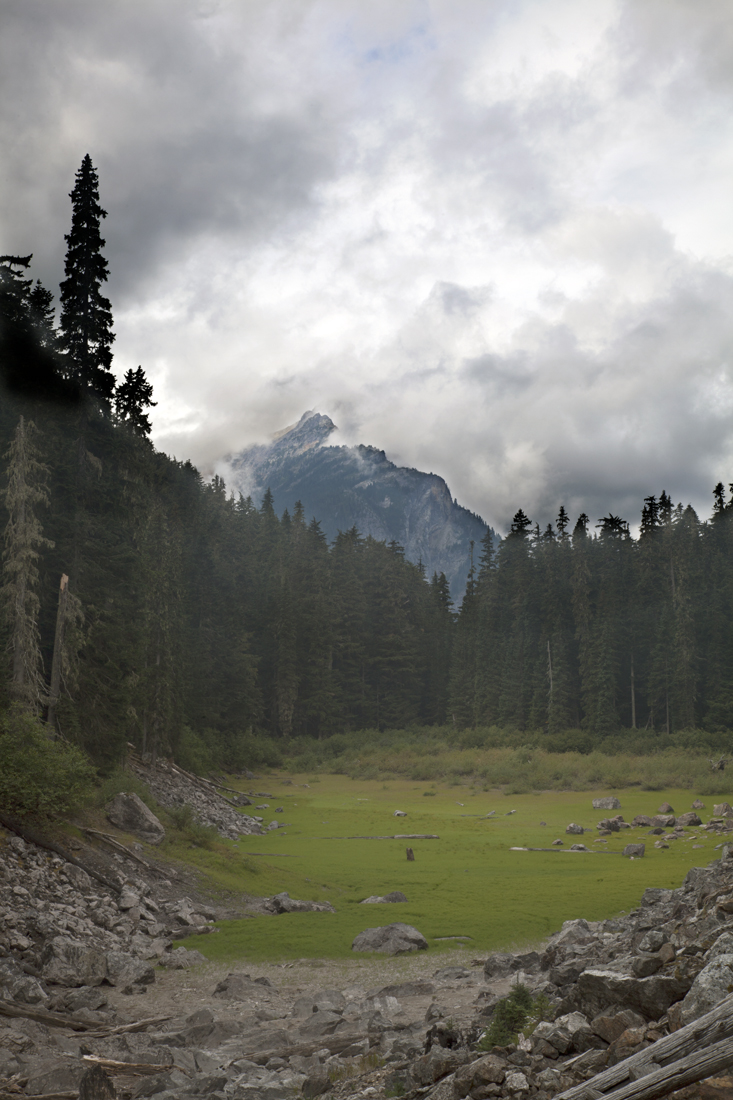
 |
| Outlet of small lake north and west of Klesilkwa Mountain. |
 |
| Canid track in mud of pond and outlet of Klesilkwa Mountain lake. Guessing that this is a wolf or very large coyote. The track is about 10 centimeters or 4 inches long. There was no sign that humans had been in this area recently, no tracks, fresh fire pits etc. so this was probably a wild canid. |
 |
| Salamander in outlet pond. This is probably a long-toed salamander (Ambystoma macrodactylum). |
 |
| Looking east at Klesilkwa Mountain lake. Clerf Lake is on the other side of the ridge to the left of the frame a little bit. |
 |
| Looking north at Klesilkwa Mountain lake. |
 |
| Looking northwest at Klesilkwa Mountain lake on my way up to look over ridge to east at Clerf Lake. |
 |
| Clerf Lake from ridge between it and Klesilkwa Mountain. The Klesilkwa River is in the next valley over. |
 |
| Close up of unnamed (as far as I know) peak or knob above Clerf Lake. |
 |
| Looking down at notch at top of route we were thinking about taking the week before to get into Klesilkwa Mountain lake. It doesn't look bad here but my stomach was churning with vertigo when I took this photo. The notch looked navigable but it dropped off almost vertically right below. The steep spot isn't in view and I wasn't about to lean over the cliff to try to get a more descriptive shot. |
 |
| Looking northwest on my way back down into Klesilkwa Mountain lake. The wind was blowing pretty hard here and it was cold enough to make my eyes water even though it was the middle of August. |
 |
| Interesting rock I came across by lake. It looks like it is a conglomerate (combination of several different rocks) but I don't know this for sure. |
 |
| Looking west at outlet pond below Klesilkwa Mountain lake. |
 |
| Looking southeast at Klesilkwa Mountain above lake. |
 |
| The sky was overcast most of the day, obvious from this photo. |
 |
| Bur-reed (Sparganium spp.). In pond at side of road at head of Silverhope Creek near pass between Silverhope and Paleface Creeks. |
 |
| Black bear tracks in mud of roadside pond. |
 |
| This was a small bear. I put my foot in the frame for scale. |
Slide Lake Aug 18th
Sacha and I took the kids into Slide Lake. Kids did the trail okay. They are fully capable of doing this trail but there was a little drama and whining at the start. Once we got doing everything went okay and everyone seemed to have a good time. Caught three fish. Interesting. When I was a kid and at least into the 1990’s the fish in this lake were westslope cutthroats (Oncorhynchus clarki lewisi) or at least that is all we ever caught. Then the first time we took Vashti in there when she was still a baby, all I caught were coastal cutthroats (O. clarki clarki) which are the cutthroats that are native to our waters (all of these fish had been stocked since Otter Creek, which drains Slide Lake goes subsurface for about a mile, presenting a migration barrier to native fish). This time one fish we (I hooked them and Phoebe reeled them in) caught looked like a westslope cutthroat, one looked like a coastal cutthroat and one looked intermediate between westslope and coastal cutthroat. I have a hunch that the genetics of these fish were pretty complicated. Some years ago I worked with USGS on genetics of rainbow/cutthroat hybrids and in those fish, one that looked physically like a rainbow might have a majority of cutthroat genes and vice versa.
 |
| The start of the journey with a little attitude being displayed. |
 |
| A little farther along and everything going smoothly. |
 |
| Large Douglas-fir log bucked out of the trail in 2003. Every year we have gone into Slide Lake we took a photo here. |
 |
| The dry lake bed just below Slide Lake. This area looks like it is ephemerally wetted in the spring/early summer during snow melt. I think I have only seen water here a few times. I had never actually been down into this area so we decided to explore a little this time around. |
 |
| Large rock near the edge of the dry lake bed. |
 |
| Thick monoculture of asters-possibly daisies (Erigeron) in dry lake bed. |
 |
| Slide Lake. |
 |
| Phoebe checking out the fishing pole. |
 |
| Phoebe with the fish. |
 |
| Close up of the fish. The upper one looks like a westslope cutthroat (Oncorhynchus clarki lewis). The middle one looks like a cross between a westslope cutthroat and a coastal cutthroat (O. clarki clarkia). And the lower one looks like a coastal cutthroat. If one were to do genetic testing on these fish, the genetics might tell a different tale than the phenotype (looks). |
 |
| Interesting pattern of growth around hemlock log bucked out of the trail. The fungus appears to have populated the sapwood, or living part of the tree when it was still alive. The sapwood of a log seems to be the first thing to deteriorate when a tree dies. I suspect that it is the first to be colonized by fungi and other organisms because, since it was the living part of the tree, it has a higher content of easy to digest simple sugars and nutrients than the heart wood which is non-living, harder to digest complex sugars like cellulose. |
Walker Creek Pond 1956 foot elevation, Aug 24th
Had planned to go back to B.C. and do another trip, heading in Friday, the 23rdand coming out either Saturday or Sunday. Only supposed to be slight chance of showers Friday, then partly sunny Saturday. Planned to get in on Friday hopefully after the showers and hope for better weather Saturday. Sky overcast when I started out Friday morning. Had a few stops before heading to B.C., chiropractor and steel place to get material for water well cover. By time I got to Concrete rain was pretty steady. Chiropractor appointment a little after 10:00 a.m. Got there in time and got material for well cover. The whole time it rained pretty steadily. Ate lunch and started north. Still raining steadily and didn’t look like it was going to let up. Couldn’t know exactly what weather was doing where I had planned to go but I strongly suspected it was raining pretty steadily there as well. I would probably have to go through a lot of wet brush to get to where I wanted to go and it would be socked in to the point I wouldn’t be able to see anything. Got diverted by some road construction and decided to cut my losses at about 1:00 p.m. If I went all the way to Chilliwack Lake like I had planned and it was a bust at this point I would be getting back really late. Decided to just head home and take care of a few chores and go out on a closer day trip on Saturday up Walker Creek in the Cultus Mountains on Saturday. I had planned on going into these earlier this year but things didn’t work out. As it was now, the walk would help keep my legs toned up. Quit raining about 2:00 p.m. and got sunbreaks by 4:00 p.m. Walked dog, watered cows and checked out some things down on my place. Even though there were sunbreaks, I still got soaked walking through the brush on my place. Got started about 8:00 a.m. on Saturday. Plan was to go into two mapped ponds on Walker Creek. I planned to access the area from the Walker Valley ORV park. Park was pretty crowded but found a place to park and started up the hill. Took shortcut through pit near bottom of one road. Didn’t know if hiking was allowed but didn’t see any signs prohibiting it. Fortunately didn’t run into too many people and heard them coming well before they got to me and was able to get well out of the way. Got to first “pond” at 11:30 a.m. As I had suspected it wasn’t really a pond. It was a flat where it looked like there was standing water occasionally during spring runoff and other floods. Otherwise there were just a few pools here and there from stream oxbows. The whole area was covered with a canopy of alders that were growing on higher areas throughout the flat. Walker Creek had a surprisingly high gradient 2-3% here, considering it was a flat and was represented as standing water on the USGS Quad. Of course, it could have been flatter at one time and been filled in by alluvial deposits from the creek. There was a berm in the flat, running to the creek that looked artificial, like someone had built it. I was surprised to see fish in the creek. I figured that there had to be a barrier below this point. Of course someone could have planted the fish here but the stream was pretty small, only a couple feet wide. Maybe an old millpond or storage pond that someone dumped fish into. The creek was so small that I figured that I couldn’t really fish it. By the time I got close enough to drop a line in, the fish would see me and spook. Got through investigating the flat at a little after noon and had lunch. Decided that I had time to try to get into the next pond up. I strongly suspected that it would be pretty much like this one, except it might not have any fish because the creek would be a lot smaller and the gradient was pretty steep and would have a number of waterfall barriers. At top of flat finally got good look at fish, good enough to determine that it was a trout of some kind but wasn’t set up to fish such shallow water. Easier with bait and you have to sneak up on holes so you don’t spook fish. Also saw a frog. From the looks of it, a red-legged frog but it was on the edge of a big undercut bank and when I tried to catch it to get a closer look to verify my suspicions of its species, it jumped under the bank. Got some good photos, enough that I was pretty comfortable with my I.D. Found deep hole in creek at top of flat and tried fishing that but no luck. Either no fish or they weren’t interested in the fly I threw in. Didn’t see any fish. Kept following stream up, keeping to what appeared to be westernmost stream which should have taken me to the pond above. Pretty big riparian leave strip so travel was pretty good for most of the distance. Had to navigate windfalls occasionally and dive into reprod of logging unit a few times. Got to next road above where the leave strip got smaller. Had been going up east side of stream but switched to west because going looked easier. It might have been easier but it was still miserable. Large rock just above road and went on west side of it. But a bunch of trees that had been left had fallen off this side, probably because they were pretty much growing on the rock and didn’t have very deep roots. This combined with reprod in logging unit and a healthy growth of devil’s club and salmonberry made going miserable. Finally got around. Leave strip smaller so very brushy by stream because underbrush got more light. Choice between than and reprod. Took reprod a lot of time. Thick miserable. Light mist started falling. If it kept up I would be soaked going through reprod. Found on little dried up pond but didn’t look like one I was looking for. At some point mist quit but thick brushy areas still pretty wet. Didn’t look right on air photos though air photos didn’t show much detail. Finally crossed back to east side of stream. Looked like I should have been in right place but no pond. Figured maybe it didn’t exist. Pushed on a little farther then saw open spot above. Figured that this must be pond. Pushed on to open spot and discovered that it was actually a road. Shouldn’t have been a road there (before I got to pond) if I was where I was supposed to be. Therefore, I was in the wrong place, or the pond didn’t exist and I had walked right by where it was supposed to be. Assumed the latter and started up road on direction that should take me out. Shortly ran into dead end where they had blocked the road. Road beyond blockage wasn’t as well used as one on my air photo so realized that I was actually in the wrong place. Headed back in the way I had come from. Didn’t know exactly where I was. Hadn’t printed large air photos so wasn’t even sure I was on the photos that I had. Didn’t trust USGS Quad because the roads shown on it were probably pretty old. There were a lot of new or newly opened roads that could make it hard to determine where I was. Good thing was that I would probably be okay as long as I followed road down. Might have to backtrack once in a while but roads would lead to valley floor. Might be quite a distance from where I parked rig but I would get down. Could also just cut down hill but decided to stay with the easier walking on the roads. Got to intersection and dug out air photos and was able to determine where I was. I was in pretty good shape. Now it was a matter of just chugging my way out. Something about going downhill on roads and trails at end of trip. Tired and pace usually settles into monotonous rhythm that causes pack straps to start cutting into shoulders. Got back down to pit where I had cut up hill and started down road instead of taking shortcut through pit but changed my mind and cut down through pit. Got back to rig and saw that I had gotten a nice parking ticket for the sum of $99. Wasn’t too surprised about that. Place is really popular so I’m sure it is patrolled regularly. Still bummed out though. Too bad I forgot pass at home. Soundtrack in my head for day was pretty much Judah and the Lion: Why Did You Run? Got really tired of that so switched to Psychedelic Furs: Heartbreak Beat at some point.
Depot Creek to Masselpanik Creek, Aug 30th to 31st
Plan was to go into about 6 lakes/ponds draining to Masselpanik Creek which drains to Klesilkwa River which drains to Skagit. Masselpanik FS Road pretty badly overgrown at last check earlier this year and probably not accessible very far by vehicle. Shorter route looked to be via Depot Creek trail then up a side valley running from Depot Creek (or more accurately, into Depot Creek) into an area near headwaters of Masselpanik Creek. Had hoped to do trip over Labor Day weekend. As per usual this year weather was shaping up to be nice during the work week and iffy over the weekend. Didn’t look like a washout except maybe Sunday but looked cloudy enough to hide most of surrounding mountains or even ridges I had planned on taking. Took Thursday off work to try to beat weather. Lower part of Depot Creek FS Road brushed out a bit which made me a optimistic that it would be in pretty good shape. Had been pretty rough last time I was up it in about 2008. Vegetation closed in at first “Y” in road, not a good development. Road got pretty rough but looked doable. Shifted into 4 wheel drive high and continued. Pretty soon shifted into 4 low, or thought I did. Road had been traveled frequently and often but brush close on either side, made me a little nervous. Tried a slightly different route over another bad spot over some big boulders and got high centered. Not good. Road tight and I was blocking anyone who wanted in or out. This could be a long ordeal that ate up all of my time for walking. Set brake and got out of rig and checked it out. High centered on rear end just barely. Worst part was that I was almost in the boulder filled ditch. If I got off boulder I was on and ended up in that ditch, I would be really stuck. Passenger tire off ground about an inch. Front tires on ground so got back in and tried to reverse off boulder. No luck. Got out and looked things over again. Noticed rock I was high centered on sloped in direction of passenger side of pickup, the side that was off the ground. On a whim, braced myself and grabbed under driver’s side wheel well and shoved with my legs, aided by a bit of adrenaline in my veins. Relieved when pickup shifted quite a bit. Tried shoving again with no result. Stopped there, didn’t want to hurt myself. Looked and saw that passenger wheel now on ground and rear end was off boulder. Hopped back in rig, started it up and made sure front wheels were pointed back toward road and not ditch. Put it in reverse and backed out. Hit boulder hard with front end but kept going and was back into road. Relieved. Backed down until I could turn around. Checked under pickup, worried about hole in oil pan or damage to rear end and front end. Didn’t see any dripping oil. Good sign but I couldn’t see really well. Took about 6 forward and reverse to get back headed the other way and headed back out. At some point seemed like I was going too fast and checked to see if I was in four-wheel drive and realized that I hadn’t been. Briefly thought about turning around trying again, using the right route through the boulders but decided enough was enough, especially since everything this year has been a little bit off for me. Parked down at “Y” in road where road got better. Rechecked underneath rig and everything looked good. Added a little less than a mile to my walk. I had almost made it on road. Depot Cr trail on USA side had lot more windfalls than last time I was over it in 2008, having recently been logged out by Canadian climbing club at that time. More logs down this time around and lost trail a few times. On maps valley looked kind of gradual and border also crossed it making the contour lines on the different maps I had look different so I wasn’t sure what to expect. The times I had been up trail before I hadn’t been looking for this valley so I didn’t know if it would be easy to spot from trail. Creek draining valley paralleled Depot Creek for quite a distance and I wasn’t sure I would be able to identify it when I crossed it on the trail. On air photo there were several large vine maple patches across creek from upper valley. If I could locate these, then I could just head north for the valley at that spot. Lost trail again in swelter of windfalls and finally decided to just head for border at that point and follow it until I hit the valley. At the time I thought that this would be a foolproof way to find the valley. Got to border cut in a short time and started following it east. Border cut was pretty brushy so stayed just below it. Ground was pretty steep sidehill in a burn that was 80 to 100 years old. Lots of small windfall logs to get over. Ran into small creek but valley was much steeper than I expected so I figured that it wasn’t the one I wanted. Continued on for several more hours, expecting the ground to break into a more gradual slope as I entered the valley. Finally stopped and checked maps again next to a steep rock outcrop at about 5:30 p.m. By this point, I realized that I had messed up. Even if I did find the valley, at this point it was too late to get to the flat on Masselpanik Creek. Didn’t want to camp in valley on Depot Creek side because it looked like there was a good chance I wouldn’t be able to find water. The lake in this valley looked very dry on air photos. Decided to bag it, go back to Depot Creek and camp for the night and figure things out in the morning and scout the route out. Figured I was pretty close to the valley but didn’t know how close. On the way back I came across it. There was a well defined land feature, a bench, about 40 feet high that I had to climb up to get to flat on top where Depot Creek ran about a quarter mile away. Once back on trail, dropped pack and started up trail to see if I would be able to see the main upper part of the valley where it came between two ridges. Sure enough, only had to go up trail a little bit and look back in direction I had come and could see wide gap of valley between two ridges. Oh well, too late now. Picked what looked like good spot to camp but when I went to pitch tent noticed that it was within the kill zone of large silver fir snag. Top broken out of snag but still enough left to hit little flat where I wanted to sleep and probably crush me. Getting late at this point, after 7:00 p.m., and would be getting dark soon so didn’t have a lot of time to find another spot. Moved a short distance away but spot was far from ideal. Large hump in ground would make it hard to stretch out and get comfortable but I finally decided that this was as good as it was going to get. Pitched tent, cooked and ate dinner and turned in a little after 8:00 p.m. It was already starting to get dark. Didn’t sleep well that night. Right hip had begun bothering me at some point but didn’t really notice it until I dropped my pack at trail. Hurt worse than it had for years, a deep throbbing pain. Must have tweaked it somehow on sidehill or in crawling over some log in a way it didn’t like. Large hump in ground where I was trying to sleep didn’t help and actually made it worse if I got in wrong position. Felt like I woke up every ten minutes all night long to try to get in a more comfortable position. Must have slept for some pretty good stretches though because night seemed like it was over pretty quickly. Didn’t linger too long in sleeping bag that morning because it wasn’t very comfortable. Ate breakfast and started out for the valley. Right hip was killing me, constant throbbing pain. Hoped it would go away the more I walked but it seemed to persist. I started to wonder if I was done for the year. Found the valley and started up. It was actually much more gradual than I had expected. One small, steep hill at border cut. Small flat right in the middle of the border cut. This might have made it hard to pick up the valley if my plan from day before had worked and I actually got to this point because the valley actually wasn’t very well defined here. As it was this day, I had been following the valley for a good distance and knew the trend or direction it was following. Valley still quite gradual on Canadian side. Another steep hill that was a bit bigger that the one at the border just below lake. Sure enough lake was dry. Pretty cool spot. Looked like the lake filled up during snowmelt runoff and maybe heavy rainfall floods but then dried out pretty quickly. Estimated that water might get as deep as ten feet in deepest spot. Horsetails so thick I couldn’t see ground at north end of lake. Took break and some photos at north end of lake before continuing up valley. On maps looked like I was about two-thirds of the way to the headwall of this valley and the flat on Masselpanik Creek. Looked like the remnants of an old trail through talus at north end of lake but couldn’t be sure. Valley got a bit steeper above lake but not too bad. Valley bottom very brushy so stayed on the sidehill above it. Pretty soon hit an old trail. I hadn’t been imagining things earlier. Trail looked like it was an engineered, built trail and not some way path. Actually followed it through a nice switchback. Trail trended up valley towards flat on Masselpanik and I assumed that was where it was going. About half way between Dry Lake and valley headwall brush in bottom of valley petered out and was replaced by large talus slopes below cliffs. Was pretty much like this to head of valley. I stayed on sidehill on west side of valley. Would pick up parts of old trail and lose them again. Toward top of valley started running into brushy patches more and more frequently, mostly vine and Douglas maple. Several times debated turning back, could see that this would be a doable route so why to trouble of pushing through brushy areas? Finally lost trail for good but kept going because at this point I was almost at the flat. Much steeper here but still doable. Finally found bear trail that went the last several hundred yards up to flat. When I finally got to top, I was surprised to see there was a berm ranging in size from about 30 feet to 50 feet or more. On maps, this valley looked like it was an example of headward erosion into the flat on Masselpanik Creek, in which case, the flat should have been flat until it dropped abruptly into the headwall of Dry Lake Valley. This was kind of a mystery. Took a few photos from top of Dry Lake Valley. Was going to go back the way I came but looked like there was a good route down through talus a little farther around headwall on east side of valley in talus slope below cliffs. Worked my way around to that area and found this to be a better route than the one I took in. It looked brushy near the top from the other side of the valley but only had to get through a few, fairly open tag alders to get into the talus. Talus was pretty old (no new rockfall) and lichen encrusted and there was a distinct line between the talus that had come off the cliff and the talus in the valley floor. Followed talus down until I found a good spot to cut back up onto the west side of the valley. Took sidehill on west side of valley to avoid brush at bottom and made it back to Dry Lake pretty easily. Had heard small stream near bottom of hill below Dry Lake on way in and headed for there and stopped for lunch. Got back to camp at about 4:00 p.m., packed up and headed out. At some point during day’s walking my right hip quit hurting so badly. Strangely, I hadn’t really noticed when. There was no distinct cessation of pain, it just kind of magically disappeared. Got back to rig at about 6:30 p.m. Pulled pickup out of parking spot and checked for any oil on the ground that might have come from rear end or transfer case. Nothing. Very good. Since big trip was shot, planned to sleep in back of rig and explore route up Paleface Creek next day. Thought I might be able to camp at main road where it crossed Paleface Creek and head up road next day but when I got there looked like it would be a pain to get down to creek for water so decided to head up road. Road crossed nice spring not too far from Trans-Canada Trail so figured I would camp there for the night. When I got to that point it was after 8:00 p.m. and getting pretty dark. Rather than cooking dinner, I raided my lunch stash for wheat thins, teriyaki sticks and boiled eggs and turned in for the night. Slept really well that night, something small but still pretty big got into wheel well of pickup, bigger than a mouse, a rock rabbit or chipmunk. This thing ran around and made quite a racket for a while but finally went away. Didn’t feel like cooking in morning so had a couple of breakfast bars and was on my way. Pulled pickup out of parking spot and checked for any oil on the ground. None. I figured I was probably good to go at this point. Drove up road about another mile. They had built a new road here and there was a new logging unit on a northeastern tributary of Paleface Creek. There were a couple of small lakes near the head of this tributary and it looked like it wouldn’t be too hard to get into them and then over the ridge to the northeast of them into an unnamed (as far as I know) lake at the head of the Klesilkwa River. I had been into this lake in 2015 but still needed to hit a couple ponds in the area. This looked like a better route than following the old logging road up the Klesilkwa River. Andy Z. and I had followed part of this road up the Klesilkwa earlier in the year when we went into Clerf Lake but to get to the lake at the head of the river, I would have to take another road off of it that looked pretty brushy. So the route from Paleface Creek looked like it might be a much better one and probably quite a bit closer as well. Got started about 8:00 a.m. Crossed outlet stream of lakes which was pretty brushy but I didn’t have to go far. Started up through timber on south side of stream. Talus slope just beyond timber to south but decided to stay with timber, especially since I would have to bash through more brush to get to talus and going was pretty good in timber. Went like that for quite a distance. At one point talus extended into timber a bit and I could have gotten into pretty easily but decided to stay with timber. This proved to be a mistake. Not far above this point, ground started to get really steep around some rock bluffs. Really brushy too. Looked like I was close to the flat where the lakes sat so I found a spot through and kept going. At top of this little chute took note of snags and a log that looked like shredded wheat cereal in case I needed to find my way back to this spot to get through bluffs. Hopefully I would be able to find it in all the brush. Already thinking about trying to get into the talus to the south. I thought it came all the way up the slope almost to where it broke into the flat where the lakes sat and it would definitely be easier going than through the bluffs. Continued up another hundred feet or so and hit some more rock bluffs. Found another way through over a limby windfall tree that was a royal pain to get over. I was definitely going to look for another way out. Still noted surroundings just in case I needed to find this exact spot again. Another hundred feet and I topped out the ridge and could see the lower lake a few hundred feet below with a nice gradual slope between me and it. Again noted surroundings and started down. Not too far above lake ran across a well beaten trail. Lots of ripe blueberries around and had already seen some bear scat but this trail looked like it had resulted from human activity not wildlife, even bears. Headed to outlet of lake and dropped pack and followed trail. Sure enough, I started seeing flags. So this would be my route out. Some flags looked new but others older and trail looked like it had been around for at least a few, if not many years so probably predated most recent logging activity. Checked out lakes. Very nice spot. Supposed to have 30% chance of showers for this day but none came and, as day went on it cleared up even more. Could see saddle or ridge I would need to go over to get into the Klesilkwa. Looked quite doable. It wasn’t too far away and I had originally planned on walking up and scouting it. However, I kind of wanted to get going and I had looked at the other side in 2015 and recalled that it had looked like a very doable route then. I might that regret decision but I called it good looking at it from the lakes and headed out. Trail out was more of a flagged route but easier than wayfinding. It looked like whoever made it took some effort to conceal it a bit on the lower end so I won’t go into more detail about it out of respect for that. Hopefully they won’t mind my mentioning it. Of course it is going to be buried in a wall of words so it is pretty unlikely that I will blow their secret. Got back to rig at about 2:00 p.m. Pulled pickup out of spot where I had parked and did one last check for any oil on the ground but didn’t find any Then I headed down the hill. Line at border was short so got back home pretty early, sometime around 7:00 p.m. Sacha wasn’t expecting me until the next day. Next day went to upper lake/pond on Walker Creek that I had missed the week before. Remembered Discover Pass this time. Had been a few showers early in morning but was clearing by time I got started up hill at about 10:00 a.m. Really muggy. Was dripping sweat in half an hour. Got up to small upper pond at about 12:00 p.m. Pretty much what I expected. No standing water and pretty much impenetrable mass of willow with a few alders in overstory. I spent my time walking mulling over the Dry Lake Valley on Depot Creek in B.C. and, at some point on the walk up the hill, I had an idea what had happened on the upper end of it. It seems reasonable that the berm on the Masselpanik flat at the head of the valley was a terminal moraine from a lobe of ice that had occupied the valley, maybe during the last ice age. When the ice melted back, the pressure was relieved from the bedrock on the east side of the valley and the rock there crumbled into the valley, forming the talus slopes. The process of rock breaking loose after pressure is relieved is called exfoliation and is a well known process. They don’t like to drain unlined power tunnels for hydroelectric plants because of this process. When the pressure of the water is relieved, rock has a tendency to fall from the walls into the tunnel where it can migrate down and cause problems with generators. I don’t know if my idea is right or wrong but I wrote it down anyway before I took notes on the upper Walker Creek “pond”. Got back home at about 6:00 p.m. Next day, Labor Day, went fishing with Sacha and the kids. Didn’t catch many fish but had a good time.
 |
| Looking north at the Dry Lake just after I broke free of the timber. |
 |
| View north at Dry Lake just after I broke free of the heavy growth of willows seen in the previous frame. |
 |
| Looking south at Dry Lake. The light green in the lake bed is a growth of solid horsetails. |
 |
| Heavy growth of common horsetail (Equisetum arvense). This grew so thick that I couldn't see any soil. |
 |
| More horsetails. |
 |
| Looking southwest at Dry Lake as the clouds start to lift. The mountain in the background is probably No Doubt Peak (a play on the name of the nearby Mount Redoubt?) |
 |
| Another view looking south at Dry Lake. |
 |
| Another view looking south at Dry Lake. |
 |
| Zoomed in view of No Doubt Mountain. |
 |
| Looking down Dry Lake valley from its head on the flat on Masselpanik Creek. |
 |
| Another view of No Doubt from head of Dry Lake valley. If this is No Doubt Peak/Mountain, it is just on the U.S. side of the border. |
 |
| Looking southwest at Dry Lake on the way back as the clouds are really starting to lift. |
 |
| No Doubt Mountain from Dry Lake. |
 |
| Looking north from the middle of Dry Lake. The trail I made walking through the thick growth of horsetails can be seen near the middle of the frame. |