This was my third trip into Sonny Boy Lakes. The first time,
in 1987, I decided I was going to quit chewing tobacco. I threw an almost full
can of Copenhagen away before I headed up the ridge between Kindy Creek and
Sonny Boy Creek. The plan was to go up the ridge and contour into Lake #2 at
the right elevation.
At that time I never carried any water with me. The ridge is
dry. About half way up I decided that I would take a break and have a candy bar,
figuring that, since I had just quit chewing and wasn’t spitting all the time,
I would have plenty of water in my system. The candy bar was a Whatchamacallit.
Instant severe cottonmouth ensued.
To make things worse, I wasn’t nearly as far up the ridge as
I thought I was. I still had a long way to go. By the time the ridge started to
get a little more open, I was feverishly stuffing blueberries into my mouth to
try to get some moisture. If anything, the berries were a kind of torture. They
had moisture but each one had so little it just teased me. It would take
forever to pick enough to quench my thirst.
I continued on up the ridge until I hit a dead end. There
was an abrupt break in the ridge and it dropped vertically. I don’t remember if
it was forty feet or a hundred feet, but it was a lot further than I would care
to fall. The only way down was this nearly vertical rock face maybe 30 feet
high. I am no fan of heights and that thing gave me the willies. It would have
dried my mouth out with fear except that my mouth was way beyond that already.
To make things worse, I could see and hear Sonny Boy Creek down below me. There
was an old broken water bottle that someone before me had left at the break in
the ridge. It had captured maybe a mouthful of rainwater that was green with
algae and was beyond what I would drink even in the state I was in.
I steeled myself and climbed down the rock face with trembling hands and my heart in my mouth the whole
way. Under ordinary circumstances, the water in Sonny Boy Creek is nothing to
talk about, kind of warm and bland but, when I finally got to it that day, it
was the nectar of the gods.
The second time I went in was in 1997 and I had a different
plan. I would follow the ridge again but this time I was packing water and I
would cut off the ridge before the break. My mom had just gotten a cell phone
and convinced me to take it with me so I could call for help if needed. I
hadn’t made it into Lake #1 on my first trip so that was on my itinerary. I
also had a newfound interest in amphibians.
The first part of the trip was hard work but relatively
uneventful. I happened across an old hard hat again that I had seen on the
first trip. The top had been smashed in, either out of spite or as a prank and
had been abandoned there. It had been left upside down and there were several
inches of forest duff in it. This was evidently left over from a fire fighting
effort some years before. A little further up the ridge from the hard hat there
was a makeshift helipad made from sapling logs. This was still evident in 1997
but was well on its way to oblivion as forest duff.
The fun started when I cut off the ridge. I found that the
cell phone was a kind of stupid license. I could do anything I wanted to
because if I got hurt, I could always call for help. At one point, I just
bulled through some thick blueberry brush over a drop and landed on my head
from about 5 feet with a loaded rifle in one hand (the high hunt was on. I
actually could have shot a big bear but there was no way I was going to pack it
out by myself so I let it go.) When I finally did get to the lake (#2), I dropped
the phone in the creek as I was getting water to cook dinner. I tried calling
home that night and the next day from the ridge above Lake #1 with no luck.
This wasn’t at all surprising. Cell phone reception is spotty up this far today
and it was even worse back then. Of course dropping the phone in the creek
probably didn’t help either.
This time I decided to go up the creek. Water all the way
and no great big elevation gains and losses. The plan this time was to go into
Sonny Boy Lakes and then over the ridge into Long Gone Lake and some other
ponds on the South Fork of the Cascade River. I brought a satellite device to call for help if I needed it at the request of Sacha, my wife. This was reasonable but I didn't take it for a stupid license.
I had been wanting to go back into Sonny Boy Lake #1 for
some time. When I was there in
1997, I saw a lot of Cascades frogs (Rana
cascadae) with white ventral surfaces (belly and underside of legs). All of
the other coloration was normal so these frogs were not albinos. In 1997 these
were some of the first Cascades frogs that I had ever looked at and this didn’t
seem unreasonable.
Sixteen years later and hundreds if not thousands of
Cascades frogs later, I have never seen anything like this anywhere else. Also
a lot of the frogs I was seeing in Lake #1 were missing parts of their hands or
feet. I have read somewhere about a parasite that can cause this. So I wanted
to look here again to double check my memory.
Accessing Sonny Boy Lakes up the creek might better than up
the ridge. I don’t think it is worse. It is a lot brushier but water isn’t an
issue and you don’t have to thread your way through cliffs to get down. Either
way, it is a lot of hard work. This is true wilderness walking. No trail with
solid footing to show you the way. You have to figure out how you are going to
get through a particular spot over and around huge windfalls, through gullies
and avalanche tracks and tributary streams choked with devil’s club and
salmonberry.
The footing is always unstable. Half the time the ground
crumbles underfoot or your foot slips out from under you or you are hindered
and tripped up by brush. You will experience more than one face plant and have
both feet taken out from under you more than once. After one of these incidents
you do a quick check to make sure everything is still intact and then drag
yourself back upright, pack and all.
Psychologically this can be hard to deal with when you know
every step you take moves you further from comfort and help. I quite often
experience homesickness and can’t wait for the trip to be over with even though
I have barely started.
I started walking at about 8:20 a.m. I don’t know how hot
the day was but it was hot, at least in the high 80’s. Eight and a half sweat
soaked hours later, I was at Sonny Boy Lake #1 bruised and battered but mostly
intact. The distance I had covered was a little less than 4 miles. People always ask me how many miles to a certain place. Off trail over ground like this distance is measured in time.
Upon arrival at the lake, I immediately began looking for
amphibians. The first thing I saw was an adult long toed salamander (Ambystoma macrodactylum). I also saw a
lot of Cascades frogs, about 74, though I lost the exact count several times. I
was able to catch several and was able to get a good look at most of the
others. All seemed to have fully intact limbs and only a few looked like they
might be the white bellied ones. Every frog I was able to catch had normal
coloration.
I made camp and cooked dinner. I was thinking that maybe I
was mistaken. Unfortunately, since I was just getting started with amphibian
observations in 1997, I didn’t make very good notes. I had taken a number of
photos but I had given all of these to the U.S. Forest Service and I no longer
had access to them. I think they may have disappeared during an office move
anyway. So all I had to go on was my memory which can play some almost
unbelievable tricks on you.
I had decided to camp at Lake #1 so I would have more time
to look around. So, after dinner, I made one last circuit around the lake. Lo
and behold, I was able to catch a frog with a white belly. I was ecstatic. I
hadn’t imagined it after all. I took some pictures and measured the frog. The
only yellow on it was in the groin area.
This was one of the larger frogs I had encountered. I had
just heard a Cascades frog researcher on the radio that morning say that she
knew of individual Cascades frogs that were at least 13 or 14 years old. So
maybe I was looking at a pretty old frog, about 16 years old or so, and one
of the remaining few frogs of a cohort or group that has white undersides.
I slept okay that night but it was hard getting up in the
morning on Friday. When you are in your tent, you are relatively safe. When you
get up and start moving around, you naturally expose yourself to more risk. It
was then that I experienced a strong twinge of homesickness. I was missing
Sacha and Vashti and I didn’t know what the day had in store for me.
Before leaving on this trip, I had looked at the weather
forecast and there was a 40 percent chance of thunderstorms for Friday evening
and Saturday morning. On the way in I had walked through several burns of
different ages and it occurred to me that there were an awful lot of burns in
this area. I modified my travel plans to try to get through spots where I would
be on exposed ridges before the thunderstorms were due and to try to get out a
day earlier in case a lightning strike started a forest fire in the area.
After breakfast, I made my way to Sonny Boy Lake #2. The
plan was to take a quick look at the lake and some ponds just south of it in
the same basin. On previous trips I noticed these ponds were created by large
berms. Then I would go over the ridge to the south and over into upper Milt Creek
and the South Fork of the Cascade River.
I looked the berms forming the ponds to the south and got
some photos. I think these berms were formed by moraines because of the large material, rocks and boulders, in them. If they were formed by SAILs (Snow Avalanche Impact Landform)
the material would be finer.
It took about an hour to get up on the ridge. The route I
had planned to take looked doable but it would take me all the rest of the day.
It looked like there was lots of loose scree, the kind of stuff that slides
away underfoot and you can almost feel your strength being sapped with every
step. This would put me a little behind my desired time line. I didn’t want to
have to try to navigate exposed ridges with thunderstorms threatening to roll
over me.
There were also a couple of steep, tricky spots that I would
have to navigate, taking even more time. I could see thunderheads forming to
the north, south and east. This all added up to a decision to abandon the trip.
In a way this was kind a relief. I wouldn’t have to be
figuring out routes around a bunch of new obstacles. On the other hand, I would
have to go back through several nasty areas I thought I would never see again. I
now had some time to kill and the view was good so I stayed on the ridge and
took some pictures.
Almost immediately a mental tug-of-war began. It was like I
had the proverbial angel on one shoulder and devil on the other. On the one
hand, I felt like a failure for giving up. A little voice kept urging me not to
chicken out. Several times I almost broke down and continued on. At the same
time another voice kept telling me abandoning the trip was the right thing to
do, err on the side of caution, discretion is the better part of valor, live to try another day etc.
Finally I headed back to the lake, made camp and kicked
around for a few more hours, discovering a Cascades frog egg mass and a bunch
of tadpoles that I hadn’t seen in my earlier, cursory pass through.
Dark clouds rolled over the ridge from the south at about
3:30 p.m. and light showers, more refreshing than soaking started falling with
the sun still shining at about 4:00 p.m. This all passed after about an hour.
At about 2:00 a.m. the wind picked up and started howling
through my tent. Between 4:00 a.m. and 5:00 a.m. the rain started and quickly
turned to downpour. The thunder and lightning soon followed. I would have
congratulated myself on making the right call except I was trying to get some sleep
because the rest of the day was going to be hard. Getting sound sleep is hard
to do with rain hammering down on your tent and random flashes and rumbles and
booms. There were several strikes on the ridge above me. I was glad I wasn’t up
there or any other ridge for that matter.
The thunder and lightning tapered off about 6:30 a.m. or so
but the heavy rain continued. I knew the rain was soaking everything and would
make the brushy trip out pretty miserable. At the same time I was glad for it.
It would hopefully also wet everything enough so that if any of the lightning
strikes had started a fire, I would have time to get out of there before the
fire took off.
I was really homesick this morning. I figured I would wait
on the rain until about 7:30 before starting to pack. I have noticed that often
this time of year rain showers will stop sometime in morning. I think this might
be because once the sun comes up it is hot enough to heat the clouds and raise
temperatures above the dewpoint where condensation occurs. So the rain stops
once the sun is up a bit. I also remembered from the forecast that it was
supposed to warm back up a bit making this scenario more likely.
Sure enough, the rain stopped at a little after 7:00 a.m. My
breakfast was pretty cheerless. I ate some of the stuff out of my lunch bag so
I wouldn’t have to take time to cook. Most of my stuff kept fairly dry except
the rain fly on my tent. Still my pack felt 10 pounds heavier. It’s funny, I
wanted to get out of there pretty bad but I felt a strong sense of nostalgia
the last time I looked back at Sonny Boy Lake #2, knowing that I would probably
never see it again.
I decided to wear raingear at least at the start because
there was so much water on everything. This is kind of a trade off. You still
get wet because you sweat inside the raingear and mine had been around long
enough to be a little leaky. Still you don’t get completely soaked.
I stopped a flat at about 4300 feet in elevation in the
valley below Lake #2 and took some photos and notes. I debated doing this
because I really wanted to get going and I thought I had looked this flat over
in 1997. But I decided that I would probably never be in here again and I was
right there, only a couple hundred yards away.
The trip out was pretty much a repeat of the slipping,
tripping, falling slog of the trip in. Only it was mostly downhill and everything
was wet. I started at about 8:30 a.m. and got back to my rig at about 4:00 p.m.
Seven and a half hours. It is almost always a little faster going out. Out of
curiosity I weighed my pack when I got home: 73.7 pounds.
Though the sky was pretty much clear by the time I got out
Saturday, you could see thunder clouds building. That night there were more
thunderstorms and rain as well as on Sunday early in the morning.
It is kind of a funny thing. Much of my time on this, and
similar, trips I spent anticipating its end. I couldn’t wait until it was over. But no sooner was I back
home than I started scheming about my next trip.
The area of Sonny Boy Lakes is
a nice place and there are a lot of interesting things to look at but I don’t think I care to ever go in there again.
Postscript:
I finished writing this blog Monday. That morning the Skagit River was dark brown, evidently from a number of slides that resulted from some pretty powerful rain storms that occurred Saturday and Sunday. I heard of a number of slides and flash floods in different areas. I guess I made the right call in getting out when I did. It feels good to be vindicated in a decision but there is a lot of luck involved as well. Not all such decisions I make are vindicated. Of course, you the reader missed out. I would have had quite the tale to tell if I had survived the various electrical storms, slides and floods. I'm sure I will have other chances in the future.
 |
| The start of the trip. First thing in the morning wade Kindy Creek. There used to be a log stringer bridge across the creek that was torn out some years ago. |
 |
| The Sonny Boy Creek bridge. Another log stringer bridge that wasn't removed when the road was abandoned. This was the very first place I ever drove when I got my driver's license. I drove to the end of the road about a half mile beyond this point and promptly got my dad's pickup stuck while trying to turn around. |
 |
| Some of the easier walking. An old burn probably 80 years old or so. A burned western red cedar stump is visible just to the left and a little above the center of this frame. |
 |
| Sunlit avalanche track viewed from the shade of the forest. This was some of the worst walking. Fighting and tripping through brush. |
 |
| Some typical brush in wet areas. Devil's club (Oplopanax horridus) and salmonberry (Rubus spectabilis) in thick clumps full of thorns. |
 |
| The comma shaped black thing in the center of this frame is a tailed frog (Ascaphus truei) tadpole. I counted at least twenty of these in just a short section of Sonny Boy Creek. Unlike our other frogs they breed in streams. The tadpole's lips are sucker like and they can actually pull themselves upstream against a current. They eat algae as tadpoles and insects as adults. These frogs are a more primitive type than our other frogs. |
 |
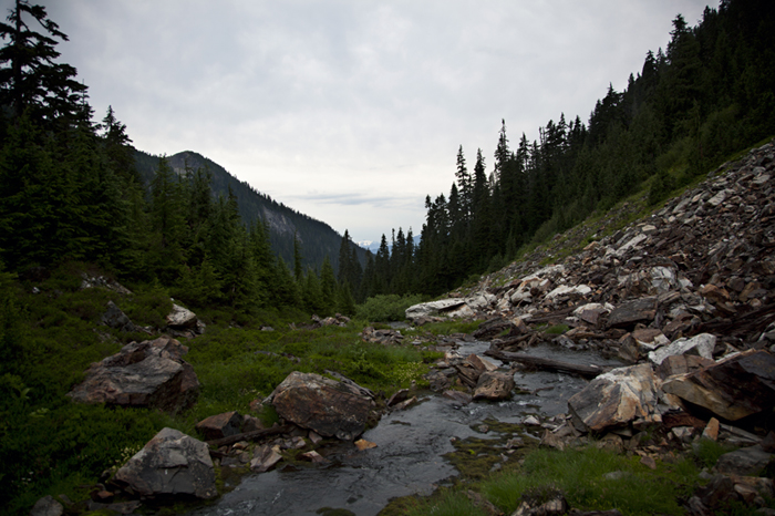
| A view of Sonny Boy Creek part way into Sonny Boy Lakes. |
 |
| More brush to wade through. Tag or slide alder (Alnus sinuata) in an avalanche track along Sonny Boy Creek. Part of a recent burn is visible as a gray area on the ridge to the right of center frame. |
 |
| Sonny Boy Lake #1. This lake is very shallow and is basically a peat bog with sedge meadows growing around it. |
 |
| Cascades frog (Rana cascadae). |
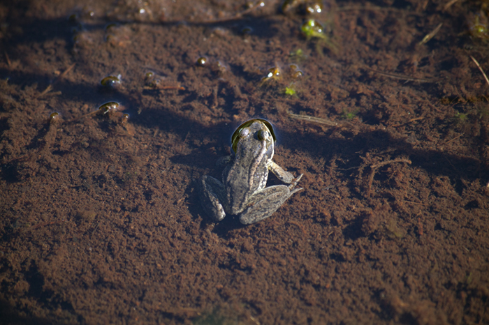 |
| Another Cascades frog. This shows the dorsal spotting on the back better. Dorsal spots that appear to have sharp edges are a characteristic of Cascades frogs though this photo is too small to show this well. |
 |
| Cascades frog with ordinary yellow or golden coloration of the ventral surfaces (belly and underside of legs). |
 |
| Ventral surface of pale version of Cascades frog. This photo was taken in the evening light after the sun was gone which affects how the colors are seen. So this frog's ventral surfaces look somewhat yellow but they are almost white. The giveaway is the red to pink legs which are usually yellow or honey colored. |
 |
| Pale version of Cascades frog (at least in my estimation). The dorsal surfaces and spots look normal though note the legs are red to pink where ordinarily they would be yellow or honey colored. |
 |
| Side view of pale version of Cascades frog. Note the only yellow present is in the groin area. |
 |
| Cascades frog egg mass. |
 |
| Mosquitoes feeding on me as I was feeding myself dinner. |
 |
| Sonny Boy Lake #1 at sunset on Thursday 8/8/13. |
 |
| Sonny Boy Lake #2 from the outlet on Friday 8/9/13. |
 |
| Berm forming pond just south of Sonny Boy Lake #2 in the same basin as the lake. I think these are moraines or maybe left when an ice lense melted out. They could possibly be SAILs (Snow Avalanche Impact Landform) that have been later covered by boulders rolling down on winter or spring snowfields on top of the berm. |
 |
| Another view of a berm forming a pond south of Sonny Boy Lake #2 in the same basin as the lake. |
 |
| View north from ridge on south side of Sonny Boy Lake #2 basin. The large gray area is a burn several years old on the ridge between Sonny Boy Creek and the South Fork of the Cascade River. At the left side of the frame in the near distance is Hidden Lake Peaks to the right half hidden by the ridge is Eldorado Peak and Eldorado Glacier. |
 |
| View south from ridge on south side of Sonny Boy Lake #2 basin. This was my stopping point. I would have had to go up the ridge several hundred more feet and then cross the scree and snowfields pictured here. I figured it would take me at least the rest of the day, maybe more if I ran into trouble navigating some steep spots to the right of the frame and near the center of the frame. |
 |
| View east from ridge above Sonny Boy Lake #2 at Mount Formidable on the Middle and South Forks of the Cascade River. Storm clouds brewing. |
 |
| View southeast from ridge above Sonny Boy Lake #2. The prominent peaks on the skyline are Le Conte Mountain and Sentinel Peak (with the glacier), just above South Cascade Lake and Glacier. Storm clouds brewing. |
 |
| Zoomed in view of Le Conte Mountain and Sentinel Peak. |
 |
| Storm clouds rolling over the ridge on the south side of Sonny Boy Lake #2 basin. I had been up on this ridge just a few hours earlier taking the photos previously shown. |
 |
| Starting out from Sonny Boy Lake #2 on Saturday morning. The small white blob in the "V" at the center of the frame is Mount Shuksan. |
 |
| Doe black-tailed deer (Odocoileus hemionus columbianus). The solid black of this deer's tail indicates that it is a black-tailed deer. Mule deer (Odocoileus hemionus hemionus) are closely related to black-tailed deer but a mule deer would have a white rump with just the tip of the tail being black. I have seen a number of mule deer in this area and deer in this area are considered mule deer/black-tailed hybrids whether they have the traits of either species. I walked by within a few yards of this deer and she didn't even move. I saw a nice buck on Thursday but he was gone in several jumps before I could get a picture. |
 |
| Sphagnum ponds in large flat at lower end of Sonny Boy Lake #2 valley. |
 |
| View from a gully on the way out. The dark bump on the ridgeline to the left of the center of the frame is Lookout Mountain between the Cascade and Skagit Rivers. The white mountain to its right is Mount Shuksan. |
I have looked at these lakes on a map when fishing Kindy Creek, and wondered about hiking up there. Thank you for the post and pictures. Appreciated.
ReplyDelete