Four days, twenty lakes. Actually, depending on how one
counts, it was 26. But it isn’t as good as it sounds. Only nine counted as far
as the limits I set for myself on my high lake project. The rest weren’t mapped
and one that was mapped drained to the Columbia River, not the Skagit. Still
nine lakes in four days is pretty good.
The plan was to go into ten lakes and ponds mapped on U.S.
Geological Survey 7.5 minute or 1:24,000 scale maps near Darrington in the
headwaters of the Whitechuck River, the North Fork Sauk River and Sloan Creek.
The trip had a pretty inauspicious start. I had initially
planned to leave Saturday the 7th and come back on Tuesday the 10th. Then the
weather forecast changed for the worse for Saturday and, in addition, there was
a memorial service that I needed to attend.
I decided to take an extra day off work, Wednesday, and leave
Saturday afternoon instead. This way I could attend the service and besides,
the weather was supposed to be better in the afternoon. I figured I could get about
5 and a half miles up the North Fork Sauk trail and start from there Sunday
morning.
It was kind of late Saturday afternoon by the time I was
packed and ready to go but I figured I would still have enough time before it
got too dark. Sacha wasn’t feeling very well but she assured me it would be
okay for me to go. She was going to go to a retirement party for some good
friends that I would end up missing.
I started out and got to Darrington before guilt overcame me
and I turned around and headed back. I found Sacha at the retirement party and
she assured me that she was all right and I should be on my way. So I resolved
to head out again but I ran into someone I hadn’t seen in a while and stopped
to talk with them. Then I ran into somebody else and somebody else and so on
until it was too late to get started that night.
Sacha was just as happy I wasn’t leaving that night. She
really didn’t feel well and Vashti was a handful. But Sacha assured me she
would be okay the next day.
I started out at about 5:30 Sunday morning. The rest of the
day was pretty uneventful. I was familiar with the trail from my trip the
previous week and made sure I rested at appropriate intervals and made it to
camp in the headwaters of the Whitechuck River at about 3:00 p.m.
I had a chance to check out an unmapped pond south of and
below, Red Pass on the way in and I also checked out an unmapped pond below and
north of the Whitechuck Cinder Cone. I generally don’t seek out unmapped ponds
and lakes but if they are relatively close, and I have the time, I like to
check them out because you never know what you might find.
Monday morning I headed into what I thought would be four
lakes below the Whitechuck Glacier, east of my camp. I lucked out and came across
a climber’s route that pretty much led to the place I wanted to go. I talked to
a guy the next day who said he’d overheard someone talking about climbing the
Whitechuck Glacier, which is why I assume the trail was there. I actually learned later that this is one of the routes to climb Glacier Peak.
Before I got to the first mapped lake, I ended up at a quite
large unmapped lake. I took about half an hour to check it out then moved on. I
found the first of the mapped lakes and an associated pond. From there it was
pretty easy to get into the other two lakes on the map.
I checked out each lake I encountered in turn. These lakes
were fairly easy to examine. They were opaque with glacial flour so there was
not much to see and there was very little vegetation around them to note. I’m
sure there were several, if not many, aquatic macroinvertebrates in these lakes
but I didn’t have the gear or the time to sample for them. So I pretty much
just took pictures and moved on.
Instead of retracing my steps from the last mapped lake I
decided to loop back into the first mapped lake. My maps indicated that the
Whitechuck Glacier may have been in my way but it had receded past the point
shown on the maps and the moraine that was left behind looked steep but doable.
When I got up to where I could get a better look at the big
moraine, I was only a little surprised to see another unmapped lake in the area
formerly occupied by the Whitechuck Glacier. What was really surprising to me
was the size of this lake. It was huge, forty or fifty acres at least, I
estimated, though I am a poor judge of area.
When I got on top of the big moraine, I discovered five more
unmapped ponds and lakes of various sizes on top of it and I saw another small
unmapped lake on the opposite side of the big lake.
The presence of the lakes wasn’t really surprising nor was
the fact that they weren’t mapped. At the time the maps I was using were made,
all of these lakes had probably been underneath the Whitechuck Glacier. I also
can’t claim initial discovery of any of these. There were a lot of boot tracks
in the area as well as the trail so I am sure there are quite a few other
people who have been well aware of these lakes for quite some time.
After quick checks and photos of the lakes on top of the big
moraine, I moved on. All of the unmapped lakes were putting me behind in time.
I didn’t even try to get over to the unmapped lake on the other side of the big
unmapped lake. It would have taken several hours. I did see the other side of
the route I had thought about taking into the lake on Baekos Creek the previous
week. It looked like it was possibly doable but it was probably a good thing I hadn’t
tried this route out of Baekos Creek. By this point, on the second day of the
trip, my lake count was already at thirteen, although only the four mapped ones
counted as far as the goals of my high lake project.
It was almost 4:00 p.m. by the time I was packed and on my
way out of my camp at the headwaters of the Whitechuck. At the start of the
trip I had entertained plans of being at Blue Lake that evening after stops at
Reflection Pond, Kid Pond and two lakes at the head of the North Fork of the
Sauk. These plans were quickly abandoned. My new goal was to make it at least
to Reflection Pond, about half the distance I had hoped to cover.
I made it to Reflection Pond just in time to see the
alpenglow on Indian Head Peak. I was worried about finding water after
Reflection Pond but I decided to chance it and try to get a little further that
night. On the way I noticed that Reflection Pond just missed draining to the
Sauk, draining instead to the White River and ultimately the Columbia River so
it didn’t count for my project.
I found a little spring at the PCT junction with the White
River trail (1507) so I decided to stay there for the night. It was around 7:00
p.m. and getting dark and at this point I was pretty tired.
As I was making camp, I saw a tiny Cascades frog, my first
amphibian sighting of the trip. That night there was a pretty good breeze
blowing and I had one or more deer stomp around my tent. They stamp their
hooves sometimes when they are alarmed by something. For a moment I was tempted
to stick my head out but I was so tired I just went back to sleep.
The next morning, Tuesday, I was on my way by about 8:00
a.m., trying to make up for lost time. I made it to Kid Pond in short order and saw two more
Cascades frogs. Kid Pond did drain to the North Fork Sauk so it was number five
on my count.
My next stop was two lakes at the head of the North Fork
Sauk, about 6 miles further on off the Bald Eagle (650) and Pilot Ridge (652)
trails. These lakes were the wild card in my plans. There was no trail
indicated on the map but it looked like it should be fairly easy to get into
these lakes without one. They were not too far off the main trail and the
ground didn’t look too steep. However, if I ran into trouble trying to get into
them, always a possibility when navigating cross country, it would completely
mess up my time schedule.
I arrived at the take off spot for these lakes at about
11:00. It was at the junction of trail 650 and the high route into Blue Lake
(652a). I could see an unmapped pond near the lakes from the main trail. There
was faint trail heading in their direction. The north lake was too shallow to
support fish but the south lake was pretty deep so I imagine that it has been
stocked periodically and the trail was a fisherman’s path.
The faint trail was no great shakes but it made the going
much easier. I made it down to the south lake and had lunch there. There was no
sign of fish in the lake and I didn’t get any bites so either they weren’t very
active or they had died out and hadn’t been restocked. I kind of expected to
see salamanders in the north lake. I looked like good habitat for at least long
toed salamanders. I didn’t see any though. I did see a number of tadpoles and
several Cascades frogs.
The unmapped pond was only a little way beyond the north
lake so I checked it out too. Nothing. This surprised me a bit. It looked like
a good spot for Cascades frogs and they were in the immediate vicinity.
I made it back to the high route into Blue Lake at about
3:30 or 4:00 p.m. I took the high route because it saved me several miles of
walking. This route however, was pretty much a goat path at the top. It was
well used so there was no difficulty in finding it but I was definitely
watching my step in many places.
From the high route I could look into Little Blue Lake and I
saw that there were several unmapped ponds near it. At this point I was getting
a little exasperated. With the unmapped pond at the head of the North Fork
Sauk, my lake and pond count was up to eighteen at this point.
I made it to Blue Lake around 5:00 p.m., set up my tent and
struck out for Little Blue Lake, about a quarter mile below Blue Lake. It was
off the route on the Pilot Ridge trail that I would be taking out so I wanted
to have a look at it so I wouldn’t need to make a detour the next day.
I made it into Little Blue Lake at about 6:00 p.m. I didn’t
see any amphibians but there were lots of westslope cutthroat trout in it and I
didn’t have any trouble catching a few. I checked out the unmapped ponds which
turned out to be on the outlet stream of Little Blue Lake. At this point my
lake and pond count was twenty-two. I had also checked out some small unmapped ponds
off the trail that looked like good spots for amphibians so technically the
count was twenty six.
It was almost dark by the time I made it back to my camp at
Blue Lake and it was dark by the time I finished dinner. That night a howling
wind blew up. The interesting thing about this wind is that it was quite warm. I
had gotten an inkling of what might be coming from a strong gust when I was
pitching my tent earlier so I staked it down really well. I didn’t sleep well that
night due to tiredness and the frantically flapping tent fabric.
The wind was still blowing at a good clip Wednesday morning
though not as hard as during the night. After breakfast, I walked part of the
way around Blue Lake fishing and observing. I got a number bites but couldn’t
manage to hook anything. These fish acted like rainbow trout. Rainbows can be
quite finicky at times and bite very lightly where cutthroat usually bite
pretty hard if they bite. I have a feeling the windy conditions also affected
the fish’s behavior.
I had hoped to catch some fish to take home with me but,
after about an hour, I abandoned the attempt. I decided to drop into Little
Blue Lake and try to catch some fish. It didn’t take long to catch several
cutthroat and a rainbow. So I learned there were rainbows in Little Blue Lake
as well.
Finally I was on my way out, about 11 miles on the Pilot
Ridge trail. About half a mile later, the trail rounded a ridge below Johnson
Mountain and there, about 500 feet below me, at the headwaters of a small
tributary to Sloan Creek, was yet another unmapped pond. I would have checked
this one out too but I didn’t have enough time.
If I had known it was there, I would have budgeted time to
go into it. This is one of the reasons I set a limit on my project by targeting
mapped lakes and ponds. There are so many out there that are not mapped, you
could spend a lifetime chasing them. The trail skirted around the basin where
this pond lay so it sat there taunting and tempting me for the hour or so it
took to get out of sight of it. Maybe I will come back some year early and go
into it for a break in trip at the start of the season.
The blueberry crop in the area was abundant so I stopped for
about an hour and picked some for Sacha and Vashti. I was interested to note
that the berry crop was very good along all of the trails I walked over those
four days but I didn’t see a single bear, or bear tracks or bear scat.
So that was it. With the nine mapped lakes I visited on this trip, I have now walked into every mapped high lake and pond in the Sauk and Whitechuck River watersheds with the exception of the ponds south of Pearsall Creek which I failed to get into this year. I arrived home at about 5:00 p.m. Sacha was tired from
trying to keep up with Vashti. She had been sick for several more days after I
left and it had been challenging.
I have had people tell me that my project is important. I
have had people tell me that they respected me for getting into this place or
that place. I have to say that I have more respect for the people who stay home
and take care of their families and contribute to their communities by being on
the volunteer fire department or participating in various civic activities.
If I hadn’t come into a family so late in life maybe things
would have been different. If I hadn’t had so much invested in my high lake
project, it might have been easier to give up.
To do this trip I turned down about a thousand dollars in
overtime wages. A price was paid in time, money and effort for dubious gain. The
price wasn’t strictly monetary and it wasn’t paid by me alone. Sacha paid a
heavy price in being ill and having to mind an active toddler all by herself.
Vashti didn’t get to see her daddy for several days. Other families, military
families in particular, deal with these things all the time. But I would think
their sacrifices are for something that is more substantial than my project.
I will never be 48 years old again and if I hope to have a
chance to complete this project, I can’t wait around very much. Sacha has put
up with a lot for my sake for which I am so very grateful. Vashti will never be
the age she is now again and there will come a day when she isn’t ecstatic
about seeing her dad come home. I think the trick is to strike a balance. The
only trouble is, you need hindsight to know if you got it right.
 |
| Looking down the North Fork Sauk River from the Pacific Crest Trail at Sloan Peak and Bedal Peak on the first day. |
 |
| As near as I can figure out this is a Swainson's hawk (Buteo swainsoni) soaring over the meadows on the North Fork Sauk with Bedal Peak in the background. I saw at least 2 other raptor species soaring in the updrafts at the same time I saw this one. This was the only clear photo I was able to get. |
 |
| Sloan Peak from the route into an unmapped pond below Red Pass. |
 |
| Red Mountain from the unmapped pond below Red Pass. |
 |
| Whitechuck Cinder Cone with Glacier Peak in the background. |
 |
| Glacier Peak from the route into an unmapper pond below and north of Whitechuck Cinder Cone. |
 |
| White Mountain from an unmapped lake on the route into the lakes at the head of the Whitechuck River below the Whitechuck Glacier. |
 |
| The first mapped lake at the head of the Whitechuck River below Whitechuck Glacier. |
 |
| Water fresh from the glacier. The cloudiness results from very fine rock particles called glacial flour that is ground the the ice of the glacier. Ten or fifteen years ago there were a lot of T.V. ads for a brand of bottled water that claimed it was the freshest and purest because it came straight off the glacier. Well, this is what water straight off a glacier looks like. |
 |
| The third mapped lake at the head of the Whitechuck River. Mount Baker is visible in the background. This lake was interesting in that it had glacial flour in it but it was no longer directly connected to a glacier by a surface stream so it was not obvious how the glacial flour came to be in this lake. |
 |
| Mount Baker framed in the outlet of the lake from the previous photo. |
 |
| Black Mountain from near the outlet of the fourth mapped lake in the headwaters of the Whitechuck River. |
 |
| The fourth mapped lake in the headwaters of the Whitechuck River. Glacier Peak is hidden by the rock outcroppings in the center of the photo. |
 |
| Looking toward the outlet of the fourth mapped lake in the headwaters of the Whitechuck River. |
 |
| Looking at inlet of fourth mapped lake in the headwaters of the Whitechuck River. The map indicated that the Whitechuck Glacier or at least a lobe of it should have filled the left quarter of this frame. |
 |
| Large unmapped lake just above the fourth mapped lake in the headwaters of the Whitechuck River. According to my map, the Whitechuck Glacier or at least a lobe of it should be where this lake is. |
 |
| Looking down into the lake from the previous photo. There is another unmapped lake in the flat valley to the right center of this photo. It is not very easily seen in this photo. |
 |
| Four unmapped lakes below the Whitechuck Glacier. The lakes kind of blend in and this photo is too small to be able to make them out well but there are three more in the flat area between the obvious lake in the foreground and the Whitechuck Glacier in the background. |
 |
| Glacier Peak from the unmapped lake/pond in the foreground of the previous photo. |
 |
| Me fooling around. I used to take these type photos a lot but I have been forgetting to do it lately. Usually I am in a hurry to keep moving. |
 |
| Whitechuck Cinder Cone from the route into lakes at the headwaters of the Whitechuck River. |
 |
Black Mountain from the route into the lakes at the headwaters of the Whitechuck River.
|
 |
| View from Red Pass down the North Fork of the Sauk River on the way out the the Whitechuck headwaters on the afternoon of the second day. |
 |
| View down the North Fork of the Sauk River from White Pass on the evening of the second day. |
 |
| View down the White River Valley from White Pass. |
 |
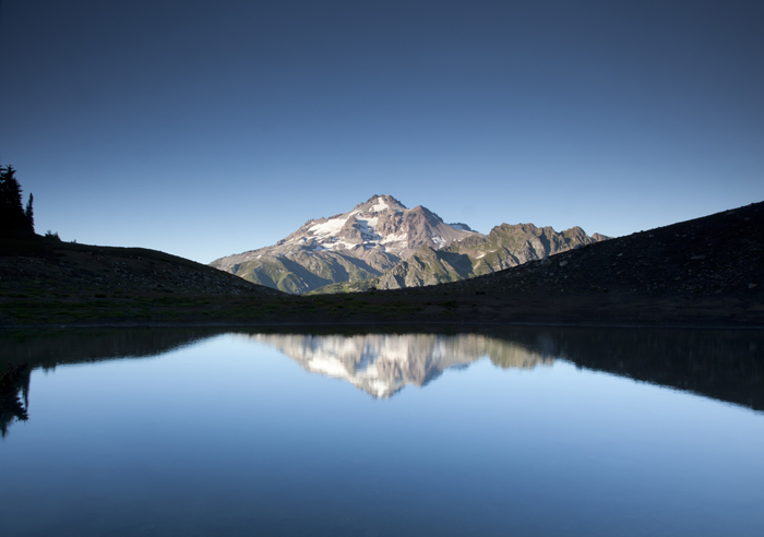
| Indian Head Peak reflected in Reflection Pond on the evening of the second day. |
 |
| Kid Pond on the morning of the third day. The Pacific Crest Trail is close beside the left side of the pond in this photo. |
 |
| Cascades frog (Rana cascadae) in Kid Pond. |
 |
| Wilderness boundary sign. Though these are designated wilderness areas and many sections of the trails here are hard to walk, walking the Pacific Crest Trail here wasn't what I would consider true wilderness walking where you often struggle with every step and have to figure out your own route around a number of obstacles. |
 |
| The opposite side of the sign in the previous photo. There is contiguous wilderness designated land running the length of the North Cascades on both sides of the crest from British Columbia to Stevens Pass broken only by |
 |
| The two lakes at the head of the North Fork of the Sauk River. The darker one to the north is very shallow, only a foot or two at most. The light blue one is deep and is likely stocked from time to time. There were no fish that I could detect on this trip but there was a way trail into the lake, indicating quite a few people go to it for some purpose. |
 |
| The south lake of the two lakes at the head of the North Fork Sauk River. Glacier Peak is near the center of the frame. The White River Glacier is to the right side center of the frame. |
 |
| Glacier Peak from the south lake of the two lakes at the head of the North Fork Sauk. The light blue color of the lake is from glacial flour although there is no glacier on this lake anymore, only a large snowfield. |
 |
| Indian Head Peak from the south lake of the lakes at the head of the North Fork Sauk. From this angle the water looks green. |
 |
| The north lake of the two lakes at the head of the North Fork Sauk River. This lake is very shallow, only a foot or two deep at most. |
 |
| Cascades frog (Rana cascadae) tadpole at the north lake. |
 |
| Adult Cascades frog at the north lake. |
 |
| An unmapped pond just north of the two lakes at the head of the North Fork Sauk River. This view is looking south back towards the two mapped lakes. |
 |
| Sloan Peak and Pilot Ridge from the high route (Trial 652a) into Blue Lake. |
 |
| Blue Lake from the high route (Trail 652a). |
 |
| Blue Lake from near my camp. |
 |
| Little Blue Lake looking southeast. |
 |
| Little Blue Lake looking east. |
 |
| Shorebird in mudflats near the inlet of Little Blue Lake. I think this is a sandpiper of some kind. |
 |
| Unmapped pond on the outlet stream below Little Blue Lake. |
 |
| Fish from Little Blue Lake. The fish on top is a rainbow trout (Oncorhynchus mykiss) and the four below are westslope cutthroat (Oncorhynchus clarki lewisi). |
 |
| The one that got away. An unmapped pond at the head of a small tributary to Sloan Creek that I didn't have time to check out. |
 |
| Blueberries were abundant. |
 |
| I picked some to bring home to Sacha and Vashti, using an empty oatmeal bag for a container. |
 |
| Mount Pugh to the left and the top of Whitechuck Mountain from the Pilot Ridge Trail (652). |
 |
| Kyes Peak, Monte Cristo Peak, Cadet Peak and Foggy Peak from left to right from the Pilot Ridge Trail (652). |
 |
| I didn't mention it in the text but I encountered immense bolete mushrooms throughout the entire trip. These were about mid-sized. I saw many two or three times this big. The notebook next to the mushrooms is about 8 inches long. |