The weather forecast for Labor Day weekend was a little
vague. Early in the week Saturday was supposed to be good, then later in the
week, Sunday as well. I had hoped to piggyback a free vacation day with some
time off work to do a long trip in the Upper Whitechuck and North Fork Sauk
rivers. Since the weather was supposed to turn bad on or after Labor Day I
decided to do a shorter trip instead.
For a number of years I had been looking at a lake at about
6280 feet in elevation on Baekos Creek, which drains to the Whitechuck River. I
figured that this would be a tough lake to get into. There are a number of
lakes on the upper Whitechuck just to the south that should be easy to access
and I had thought of trying to get from them into the lake on Baekos Creek on a
four or five day trip that would include several other lakes in the area. The
idea was that if the attempt on that trip failed, I could do a trip focusing
just on the lake on Baekos Creek later. I decided on making an attempt to get
into just the Baekos Lake over Labor Day.
This whole trip turned out to be an exercise in psychology. I
had been looking at maps of this area and trails for years and had it in my
mind that, the lake on Baekos Creek notwithstanding, this was going to be an
easy area to do. There was good access, two trails up the North Fork of the
Sauk River as well as the Pacific Crest Trail so there would be very little off
trail traveling.
In many ways trail walking is much easier than off trail
walking. You don’t have to figure out a route and your way is usually pretty
free of obstacles. In other ways trail walking is harder than off trail
walking. You need to be able to pace yourself to the trail and rest at the
appropriate times, kind of work the trail I guess would be a term for this.
I had never walked any of this trail before and, as usual, I
had an ambitious agenda. In my mind, as I started up trail 649 up the North
Fork of the Sauk, I wanted to get into the headwaters of the Whitechuck and
then down the Pacific Crest Trail to camp near Baekos Creek. The next day I
would go into the lake there and hopefully there could be enough time to get
into the four easy lakes to the south of Baekos Creek as well as some small
ponds in the Whitechuck Cinder Cone. Much of this agenda had been made up years
earlier before I had ever seen or experienced the actual conditions on the
ground.
Trail 649 is fairly flat with some relatively minor ups and
downs for the first 5 miles. Then it goes up 3000 feet in a little less than 3
miles. My average trail pace on flat ground is about 2.5 miles per hour. I got to
the Mackinaw Shelter at about 5 miles before 11:00 a.m. Instead of taking a
good rest, I pushed on hoping to have lunch at a little after noon at the
junction with the Pacific Crest Trail, another 2.8 miles further, according to
my Green Trails map.
What I didn’t take into account was that 3000 foot elevation
gain and my unwillingness to stop and rest when there was an open way in front
of me. I pushed myself too hard and, in my mind, I was going to have lunch at a
little after noon near the trail junction so I didn’t stop for lunch either. I
didn’t reach the trail junction until after 1:00 p.m. and I still didn’t stop
for lunch until almost 2:00. It was well after 3:00 by the time I reached the
Whitechuck Cinder Cone on the headwaters of the Whitechuck River. At this point
I was worn out and decided to rest and regroup.
I decided on a different plan. I would camp at the
headwaters of the Whitechuck and go into the ponds at the Whitechuck Cinder
Cone and go down to Baekos Creek the next day with a light pack and attempt the
route up the creek and consider the trip a success and be happy if I could at
least get into that one lake on Baekos Creek.
It was hard to get up the next morning. Then I moped and
dawdled down the trail, dragging my feet like kid after tantrum, a little tired
and feeling sorry for myself and dreading the off trail brush bash up Baekos
Creek. This mindset and resulting behavior probably added a couple of hours to
my trip down the trail.
I reached Baekos Creek and started up. Despite all my dread,
I had been looking online at a new type of map the U.S. Geological Survey
(USGS) has. It is a 7.5 minute quad or 1:24,000 scale map with the contour
lines that indicate how steep the ground is superimposed over an aerial photo.
These new maps give a lot of additional information not included in the old
style maps about things like what kind of vegetation is on the ground.
According to the aerial photo map I looked at of this area,
there was a lot of brush near the stream but, in the immediate vicinity of the
stream, the ground was fairly bare. I was hoping this bare ground would be a
series of gravel or boulder deposits that would make travel fairly easy. This
was the case in the lower part of the creek for about half a mile.
Then the boulders gave way to bedrock which quickly became
very steep sided and covered with numerous seeps and algae, too steep and slick
to navigate. So I hit the brush which was mostly tag, or slide alder (Alnus sinuata). I find that tag alders
are actually easier to navigate than vine maple. So they are the lesser of two
evils but, according to a quote I read somewhere, “the lesser of two evils is
still evil”. I had just figured out what time I would need to turn around in
order to make it back to camp that day when I hit the tight scrubby forest
growing in an old avalanche chute.
The trees were growing so tight in some places that it was
like walking through brush and there were thick growths of oval leaved
blueberries and white rhododendron in the open areas that made walking
difficult but it was much better than the tag alders. I stayed in this,
following the creek up and veering to the right up a side valley when I reached
a large tributary stream that entered the creek on the side opposite me. In
about half an hour, I reached an avalanche chute further up that was more
active with a bunch of trees that had been knocked down within the last several
years.
There was a fairly large tributary stream flowing through
the edge of this avalanche chute and I was able to follow it and then a smaller
stream up into some talus slopes right below the lake. From there it was a
matter of just getting up the rock slide without getting hurt.
I reached the lake in about three hours from leaving the
trail. I found it to be quite a pretty spot though it appeared to be quite
barren. The lake had a blue color from glacial flour and there was not a lot of
vegetation growing in the area. I didn’t see any amphibians. I am sure there
were a number of species of aquatic insects inhabiting the lake but these are
often difficult to see without specialized sampling equipment. I did run into a
couple of Cascades frogs along the trail on the trip out.
I also saw that, at least from the Baekos side, the route
from the lakes to the south looked fairly easy. There was also a route that
looked pretty easy down off a spur ridge of Glacier Peak.
Hindsight being 20/20, I realized that I should have tried
the route from the south first. If I had succeeded then I would have gotten
into those lakes as well as the one on Baekos Creek. I didn’t want to try to go
back that way because time was tight. I didn’t know what it looked like on the
south side of the pass. The route might not have been doable from that side and
I would have to invest a bunch of time I didn’t have in order to find out. As
it was, I got back to camp just before dark going out the way I came in.
As per usual, I saw a lot of people on the trails. The
Pacific Crest and the North Fork Sauk are both pretty popular trails and this
was Labor Day weekend and the weather was good. Off trail up Baekos Creek, I
didn’t see anyone or any signs of human presence. I find this to be very
common. I did see a lot of whistle pigs or hoary marmots and a lot of rock
rabbits or pikas in both the areas where there were a lot of people and where
there weren’t a lot of people.
The clouds rolled in rapidly Sunday night, covering
everything in about half an hour. I
expected it to be completely socked in on Monday morning but the clouds rolled
away shortly after sunrise and the day was quite beautiful on the way out.
There were several points of interest during this trip. The
first was along the trail on the way in. Just past Red Creek and then just past
the Mackinaw Shelter, the trail goes through a burn or two separate burns that
are probably 80 to 100 years old. Between Red Creek and the Mackinaw Shelter,
the forested areas are old growth in a late successional stage.
These areas provide an almost textbook example of succession
in western hemlock or Pacific silver fir forests. In the old growth area there
are very few Douglas-firs. This species is shade intolerant and its seedlings
can’t grow in the heavy shade of a forest canopy. So the most of the trees in
this area are western hemlock and Pacific silver fir along with some western
red cedar all of which can grow in the shade. In the burned area, probably
close to half of the trees are Douglas-fir. The disturbance caused by the fire
created enough open area that these trees could get established and thrive.
The other point of interest is the Whitechuck Cinder Cone which,
from a distance looks like a barren brownish sand dune in a sea of greens.
The last point of interest is a waterfall and bedrock
constriction in lower Baekos Creek which I will illustrate in the photos that
follow.
 |
| The Mackinaw Shelter at about 5.5 miles on the North Fork Sauk trail 649. |
 |
| The Mackinaw Shelter front view. This is probably not long for this world unless some work is done on it. The roof is going bad and there are mushrooms growing out of one of the rafters-always a bad sign. In addition, there apparently was no foundation put under this building so the posts are rotting where they contact the soil. This isn't surprising. I don't think many of these shelters were build with longevity in mind. A really cool building. |
 |
| North Fork Sauk Trail breaking into the open in an avalanche chute. Large amounts of snow accumulate in the winter on the bare ridges above now green with meadows. |
 |
| Three avalanche tracks viewed from the Pacific Crest Trail. The previous photo was taken in the avalanche track to the far left of this frame. The steep ground and lack of tall vegetation here make this area prone to avalanches. |
 |
| The headwaters of the Whitechuck River viewed from Red Pass on the Pacific Crest Trail. |
 |
| Whitechuck Cinder Cone viewed from the Pacific Crest Trail. |
 |
| Whitechuck Cinder Cone. |
 |
| Whitechuck Cinder Cone. |
 |
| Whitechuck Cinder Cone reflected in a small lake or pond on its south side. |
 |
| Rock forming Whitechuck Cinder Cone. This rock had a strange feel underfoot and was a weird to walk on. The smaller stuff slides very easily underfoot while the larger stuff is quite solid but is actually hard to walk on. Only a few species of plants were growing in this rock and only one of them seemed to be common here. |
 |
| Glacier Peak with Whitechuck Cinder Cone in the foreground. |
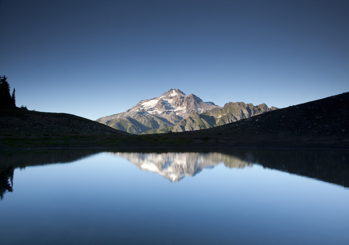 |
| Glacier Peak reflected in a small lake or pond on the north side of Whitechuck Cinder Cone. |
 |
| Blue grouse or sooty variant of the blue grouse a.k.a. sooty grouse (Dendragapus fuliginosus). |
 |
| View down the Whitechuck River Valley from the Pacific Crest Trail in the morning. |
 |
| Waterfall on Baekos Creek near edge of main Whitechuck River Valley. |
 |
| View downstream in Baekos Creek 180 degrees out from previous photo. The bedrock constriction that helps form the waterfall also restricts water flow which increases pressure and energy available to move sediment, kind of like putting your thumb over the end of a garden hose only on a much larger scale. This results in a natural "blow out" where lots of sediment moves through the constriction then falls out in large deposits or bars when the energy dissipates as the area of the stream channel increases. The large deposits or bars cause the stream to run all over the place, cutting new channels or into existing stream banks. |
 |
| View downstream in Baekos Creek just above the waterfall. The constriction in the stream slows the water above it decreasing its energy and ability to move sediment. The area above the waterfall is fairly flat so again the rock and sediment fall out and are stored above the constriction with the same result of the stream running and cutting all over the place. All of the sediment movement and storage and stream cutting occur at different points during flooding. |
 |
| View downstream from part way up Baekos Creek. |
 |
| View upstream from same point as previous photo. Just out of sight, the stream banks became steep, slick bedrock and I had to go into the tag alder brush on the other side of the stream and from there into some fairly well grown up avalanche chutes. |
 |
| Near the top of the avalanche chute I followed up. I followed the stream to the left of center of the frame for a short distance then got into a smaller side stream running into it from the right side of the frame. My destination lake was just beyond the notch at the center of the frame. |
 |
| Unknown (to me) insect, looks like a beetle of some kind on a rock with dikes or sills (the white stripes) encountered en route to the lake on Baekos Creek. P.S. I have been informed by a comment that this insect is a true bug and not a beetle. Thank you for the information. |
 |
| View west at Black Mountain and Lost Creek Ridge from near the outlet of the lake on Baekos Creek. |
 |
| My destination, the lake on Baekos Creek. Glacier Peak is at the left side of the frame. There is probably a much easier route from this direction than the one I took into the lake. |
 |
| Looking northwest over outlet of lake. Whitechuck Mountain is near the center of the frame. |
 |
| View north from the lake at Glacier Peak. |
 |
| View north from the lake at Glacier Peak. |
 |
| View west from lake at Black Mountain. |
 |
| View south from the lake. The other route I had been considering was over the snowfield and pass at center/left center of the frame. It doesn't look too bad from this side of the pass but I didn't know what it looked like on the other side. |
 |
| Whistle pig or hoary marmot (Marmota caligata) below a subalpine fir standing on its hind legs to get a better look at me. This is on a moraine just below the lake. I saw two of them in the same burrow here and heard several others in the area. |
 |
| View down Baekos Creek at Black Mountain. |
 |
| New Pacific Crest Trail bridge over the Whitechuck River. |
 |
| Old Pacific Crest Trail bridge over the Whitechuck River. Photo taken from the new bridge. I don't recall which |
 |
| Cascades frog (Rana cascadae) encountered next to the trail. |
 |
| Headwaters of the Whitechuck River near my camp. The low clouds rolled in within about half and hour and covered everything. |
 |
| View from my camp the next morning. The clouds rolled away around sunrise. |
 |
| Cadet Peak and Goblin Mountain from Red Pass. |
 |
| View from Red Pass. Cadet Peak, Foggy Peak, Sloan Peak and Bedal Peak. |
 |
| View up the North Fork of the Sauk River from the Pacific Crest Trail near Red Pass. Johnson Mountain near the center of the frame. |
 |
| Whistle pig or hoary marmot (Marmota caligata). I saw and heard a lot of these on this trip. |
 |
| Sloan Peak from the Pacific Crest Trail between Red Pass and White Pass. |
 |
| Bedal Peak from the Pacific Crest Trail between Red Pass and White Pass. Mount Forgotten is in the distance to the right of the frame. |
 |
| White Pass from the Pacific Crest Trail looking southeast. Indian Head Peak is in the background. |
 |
| Sloan Peak from the North Fork Sauk Trail 649. |


Pat - The insect on the rock in the photo above is a true bug, same family as squash bugs and stink bugs, but don't know exactly what kind. Def not a beetle.
ReplyDelete