Paleface and Tearse Creeks B.C. Sept 16th and 17th
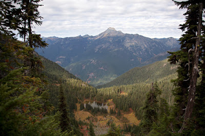
Weather supposed to be pretty bad this weekend. Decided to go to B.C. and scout out some routes. Turned down about $650 in overtime to do trip. Figured to car camp and stick to trails and roads so hopefully avoid a complete soaking. First stop was Paleface Creek which drains to Chilliwack Lake. Logging road up Paleface part of the Trans-Canada Trail and a possible route into some lakes on Masselpanik Creek. Road junction I needed to take looked like it was less than 2 miles in. Chilliwack Lake Forestry Service Road pretty rough. Had tried several years earlier to take pickup up Paleface Creek Road when it was pretty brushy and got about half a mile before deciding to turn around. Road brushed out and probably most of it driveable with full sized rig but sign indicated horses, bikes and hikers so thought it would be a bad idea to try to take pickup up road. Walked for about 2 hours up road and didn’t see road junction. This should have put me about two and a half miles in so I walked past road junction. This answered my question. If it was so overgrown that I walked right past it, I wouldn’t want to try to use it to access upper Masselpanik Creek if there was another route. There was another route off the trail up Depot Creek so my exploration here was done. Got back to rig without getting too wet. Got brushed by a couple minor showers which was less than I expected. Weather fairly nice, cloudy with a few showers when I started out but got steadily worse as I headed out down Chilliwack Valley. Forecast was for showers but it was flat dumping when I got back to Highway 1. Didn’t let up all the way to Hope and Sunshine Valley. Next spot I wanted to check out was up Sumallo River above Sunshine Valley. Was a little after 6:00 p.m. when I got to Sunshine Valley and should have had about 2 hours of light left but it was pretty dark. Checked out several spots. First road crossed river and ran up Potter Creek. Several lakes/ponds I needed to go to up there. Looked like bridge over river had been removed on air photos and, sure enough, it had been. However, four-wheeler trail led across river and up abandoned road so figured that there was a good chance the roads here would be walkable but that would take some scouting on another day. Gate farther up on Sumallo River Road said it was closed at 3:00 p.m. and on weekends but didn’t look like it had been used in several years. Since it was well after 6:00 p.m. on a weekend and the gate was open, figured the sign was outdated. Drove past and checked out route. Road I planned to use had bridge out but people had been driving 4 wheelers up it so thought it would be a good bet that I could walk it as far as I needed to. Turned around and went back to check out Ski Hill Road. Sign there said “Entering Private Property, No Trespassing”. This was above Ministry of Forests sign declaring this road to be Ski Hill Forestry Service Road. No gate and it looked like lots of people had been using road. Didn’t know how property laws work in B.C. Would think it was public land but not sure. Amount of traffic on road and lack of gate seemed to indicate it was okay to proceed which I did. Found gate several miles up with another sign that again said private property and no trespassing and no motorized vehicles beyond this point and do not block gate. Four-wheeler trail around end of gate had seen heavy use. Again not sure about things but decided to go back down road a bit and turn in for night. Still raining pretty heavily at this point. Debated just bagging it and heading back. Figured I could probably be home before 10:00 p.m. and it looked like next day was going to have lots of wet vegetation even if it wasn’t raining. Finally decided to stick it out and see how things looked the next day. Looked in back of pickup and not surprised to see canopy leaking pretty badly. Could have slept there and been a little damp but okay but decided to try front seat of pickup and save having a bunch of stuff to dry out at the end of the trip. Tried several positions and finally settled on seat back as far as it could go and leaned back as far as it could go. I always have to change positions several times during night and alternate position was coat for pillow on pack which was in passenger seat. Covered myself with my sleeping bag and found it not too uncomfortable. Listened to tunes and looked at map for a bit before going to sleep. Slept better than I expected. Snored so heavily that I woke myself up several times but woke up feeling pretty rested with no major kinks in back or neck. Chilly but clearing in morning and had hard time getting started but finally managed it. Didn’t feel like cooking breakfast so had a couple cold breakfast bars. Thew on pack and started up road. My goal was to scout out road and some possible routes into some small lakes and ponds and maybe try to get into a pond that looked like it wasn’t too far from end of road. Found a number of houses and cabins beyond gate and road continued through them. Reached large open area I had seen on air photos. Several burn piles and a couple of overgrown picnic tables. Opening offered good view of surroundings. Was able to look at routes into small pond on west side of valley as well as route into lake over ridge on east side of valley. Both looked doable. Divined location of pond near end of road. It was in valley floor on west side of valley. Wasn’t steep to get there from where I was but it looked pretty brushy and wet. Road continued on out of open area and in direction that would at least put me across valley from pond, making a trip there shorter so I followed it. Came up to ski lifts shortly. Road continued on past another sign that declared no motorized vehicles beyond this point, Sto’Lo traditional lands. Sign was kind of off road a bit. Still a bit confused but figured I wasn’t on a motorized vehicle so I continued on. Road, now mostly just a four-wheeler trail finally came to a fork near middle of valley. One fork headed in direction of pond so I took that one. About ten minutes later I was at the pond. The road let right to it and ended there. Pond interesting. Fit description of SAIL (Snow Avalanche Impact Landform). The idea of how these landforms are created is that avalanches come down and hit valley floor with enough force to excavate a crater. SAILs are typically found at the edge of the valley on the valley wall at the bottom of an avalanche track. There is typically a depression which often fills with water to form a pond or lake and a large mound on the far side of the depression from the valley wall. This is basically what this pond looked like. There was an avalanche track on the valley wall, a depression which formed the pond and a large mound about 30 feet high on the far side of the pond from the valley wall. The only discrepancy I could find was that there was a lot of large rock in the mound. There were two boulders three to four feet in diameter and a lot of larger rock in the mound. The way I understand it, SAILs are typically formed in finer material like sand or fine soil in the valley floor. Maybe this pond was formed by some other process like a snow or ice lobe slowly melting away. Or maybe I don’t quite understand the process of SAIL formation. At any rate, was kind of interesting land form. Saw several small fish 1 to 2 inches long in pond outlet. Aluminum boat stashed at pond and another wooden boat in pieces around pond. Also fishing bobber in outlet. Fished for about ten minutes with no luck. Needed to get going. Was about 10:00 a.m. on Monday and I needed to be at work next day and take kids while Sacha was at training. Trip back pretty uneventful.
 |
| Pond/Lake looking north, down the Tearse Creek Valley. There is a boat screened from view by brush near center frame on the right side. |
 |
| Looking south up Tearse Creek Valley and pond/lake and berm that helps form it. The boat is visible as a white spot near center frame. |
 |
| Looking southeast at pond/lake and better view of berm. |
 |
| Looking south at valley wall and avalanche track on west side of pond/lake. |
 |
| Looking west from top of berm at pond/lake and avalanche track. |
 |
| Looking west from berm at pond/lake and avalanche track. The photo doesn't do justice to the steepness of the valley wall and avalanche track. |
Tearse Creek and Sumallo River B.C. Sept 27th , 28th and 29th
Had chiropractor appointment on Thursday the 27th
and decided to try to get to B.C. and try to get a few more trips in for the year. Appointment was at 11:00 a.m. Got some stuff to go to eat on the fly after the appointment to try to get up to spot on Sumallo River as soon as possible. Had light until about 7:00 p.m. and wanted to try to get into small pond that day. Wasn’t too far in but logistics of getting to jump off point were difficult. Long wait at border would sink plans. Fortunately border wait was short. Had originally planned to walk up road paralleling creek until I was across from pond then cross creek and go pretty much straight up hill to pond. At last minute noticed on air photo that road in fairly recent logging unit was only about a quarter mile away. So decided to try that and sidehill from logging unit into pond. Sidehilling can be tricky. Had to gain about 300 meters (985 feet) as I was sidehilling on steep ground. Got to jump off point at about 3:00 p.m. Bridge over Tearse Creek had been removed. People had been taking ATV’s across and it looked like I could drive my pickup but didn’t know if this was allowed. Didn’t want to get into trouble in another country so decided to walk. Time was tight. Ordinarily trip like this wouldn’t be too hard-have to pay attention while route finding to pond but wouldn’t be too hard if I had plenty of time. Decided to go up cutting line in logging unit rather than walking switchbacks on road in order to save time. About 300 meter (985 foot) climb to top of logging unit. Reached there in about 45 minutes. Started out sidehilling at an angle that I figured was about right to get me to basin where pond sat. Ran into some pretty steep ground. Actually ran into some pretty steep ground in logging unit too. Looked like I was going above some pretty significant drop-offs or cliffs in timber. Would have to try to hit same spot on way back or else might end up staying night in woods. Issue wouldn’t be getting lost. As long as I didn’t cross over ridge, any direction I went down would take me to Tearse Creek and a road. Same would be true even if I managed to somehow cross ridge. Main issue was if I would end up spending a cold, uncomfortable night on steep ground or if I would be able to sleep on a nice pad in back of my pickup. Again, wouldn’t be too bad if I had plenty of time but didn’t have a lot, figured about an hour or more in and that much back out and another hour checking pond out. Would put me back out at about 6:00 p.m., an hour to spare but that hour could be easily eaten up if I had to find my way around or through cliffs. This was definitely an area that one doesn’t want to travel if you can’t see. Even with a headlight, which I had, you could walk off a cliff and not even know it until it was too late. Hit a small stream course that looked like it might be the bottom of an avalanche track. This would be a good feature to follow. Hoped to follow it up to more open area out of heavy timber where I could get bearings and landmarks so I could find my way back to this exact spot on way out. This way I would be able to hit band between drop-offs. Followed stream course up for several hundred feet but it finally disappeared. This spot was bad for finding landmarks. It was really brushy with large patches of white-flowered rhododendron spread pretty much evenly everywhere, making it pretty much featureless or at least with no distinguishing landmarks. Saw some bluffs and made my way there to try to get bearings. No luck. Couldn’t see very far. Around 4:00 p.m. at this point. Figured I was close to basin where pond lay but was debating turning back. Might have hard time finding spot through drop-offs as it was. Finally decided to continue on and trust that I would be able to find a way back. After traveling another five to ten minutes hit a pretty well traveled game trail. Figured that this was probably headed to the basin so I followed it. Sure enough, I was within sight of basin in another five to ten minutes. It is always a little farther than you think it will be. Much nicer traveling where I could see ahead to where I was going. Crossed steep meadow to rockslide just above pond. Meadows very pretty in fall colors, red, orange and gold with dark evergreens in strips or singly. On other side of rock slide a bunch of alpine fir, silver fir and mountain hemlock hammered to krummholz scrub was between me and pond. Forced my way through almost impenetrable mass to pond. Pond water pretty murky but pond quite pretty in fall colors. Did walk around pond but didn’t see much because water so murky. Saw water striders and water boatmen and several dragonflies. One dragonfly was ovipositing (laying eggs) so I got very good look at it. It was species with a black body with brilliant blue patches on the body segments. I see this species a lot but very rarely does any individual hold still for very long. This species usually appears to have green eyes when viewed in flight but the one sitting still had eyes that looked blue. Took a bunch of photos and headed out. It was 7:00 p.m. and if I ran into problems navigating back I would be cutting it close for getting back to road before dark. Stopped in talus slope and took some photos of mountain across valley. Later figured out that this was probably Mount Outram. Talus interesting in that the part farther up slope seemed pretty fresh while there was a spot lower on slope with well developed soil between rocks and a good growth of heather and other vegetation. Didn’t linger long. Was anxious to get moving. Hit far side of meadow a little high, above where I had come through. Found that spot and game trail and continued on keeping a sharp eye to try to determine where I had come through and try to hit small stream that I had followed up for a bit. That would be my key for hitting the spot between the cliffs. Took a down angle that I guessed was about the angle I took going up on the way in. Travel was pretty good, seemed better than on way in. Hit the brushy, relatively featureless area with all the white flowered rhododendron. Not too far in saw a spot that looked kind of familiar below me. On a hunch/gamble I headed down at this spot. I figured that if I couldn’t find the stream I followed up, I would just have to find another way. But I lucked out. Before long I saw where my feet had kicked out the soil on my way up the hill. It was the stream I had followed up. I followed it down to small hemlock that had fallen across it that marked the spot where I had come through the steep ground. After that I was able to retrace my steps through the worst of the spots. Now I needed to make sure to cut down at a steep enough angle that I would hit the logging unit. If I missed it, I had a long way to go down the ridge before I hit a road and it would be dark long before I got close. Found a spot to get down about a hundred feet from route I had taken in to a flatter spot where travel would be easier. Took pretty steep angle down after that, I thought much steeper than I had taken on the way in but ended up hitting logging unit at very top, almost exactly where I had left it. It was still a little before 6:00 p.m. I had it made. Took road on way out. Cost me 15 minutes or more walking switchbacks but travel was easier and I had plenty of light. Made it back to rig a little before 7:00 p.m. Ate dinner and crawled into cab of pickup and worked on field notes from the day. Laid out foam pad in back of pickup and crawled in and turned in. Sometime during the night there was a very loud rattling of what sounded like big rocks nearby even though there weren’t any steep slopes with large rocks, didn’t stick head out from under canopy to investigate. Later heard twanging of pickup radio antenna where I had hung sweat soaked bandanna. Figured that was a deer. Moon very bright and I kept waking up thinking it was morning. Slept okay though pad wasn’t nearly as good as I thought it would be. Could feel hard truck bed through it. Still a lot better than trying to sleep on steep ground in cold.
 |
| Looking south at about the spot where I broke out of the timber and into the meadows. |
 |
| Looking south and west at pond. I crossed through a talus slope above the timber and below the meadows at center frame. |
 |
| Looking south at pond. It was a fairly clear sunny day this day but it was so late in the year that the sun was already gone and things were a bit gloomy. |
 |
| Another view looking south at pond showing ridgeline. |
 |
| Dragonfly ovipositing (laying eggs). This dragonfly is a darner of some sort but I don't know enough about the different species of darners to make a confident identification. |
 |
| Darners are usually constantly in rapid motion and are hard to photograph. This one remained in pretty much the same position for a half hour or more, allowing me to take a number of different photos. |
 |
| Looking west at meadows and talus slope on the way back out. |
 |
| Looking east on way out at Mount Tearse and ridge that I would be crossing the next day. |
 |
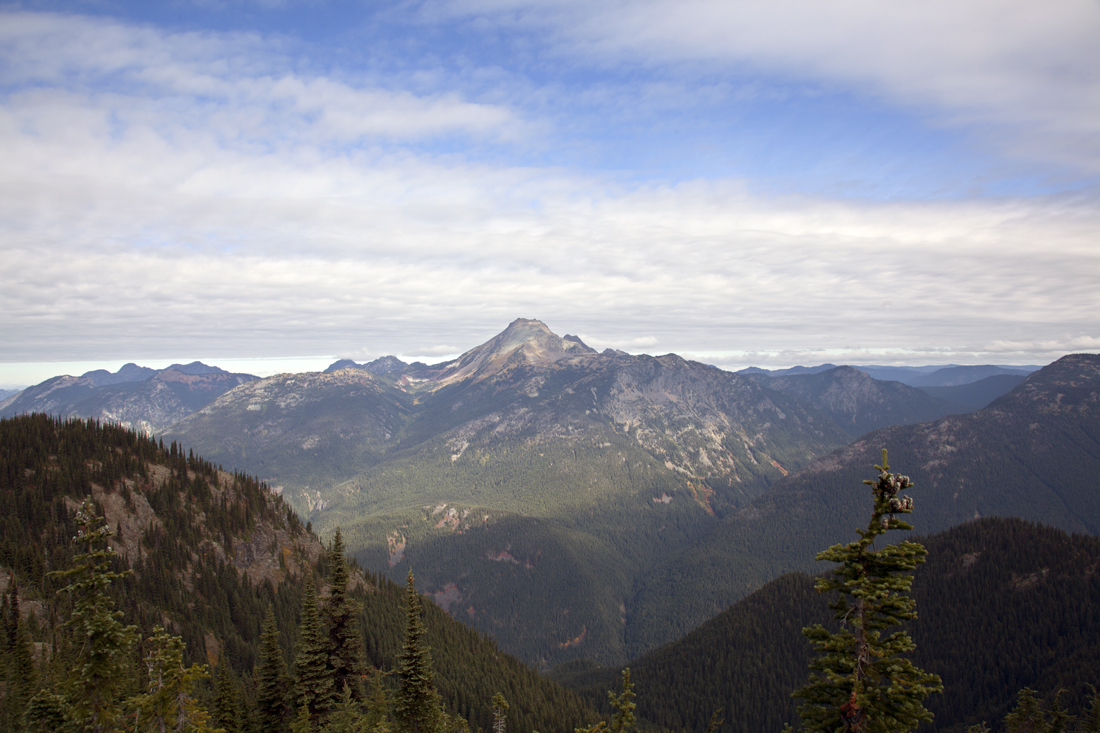
| Looking northeast at Mount Outram on way out. |
 |
| More zoomed in view of Mount Outram. |
 |
| Even more zoomed in view of Mount Outram. |
Had a slight crick in my neck in the morning which was a bummer, I had just had my neck popped the day before by my chiropractor. No help for that, needed to get on with the day. Cold that morning though it didn’t freeze but still enough to discourage me from crawling immediately out of bed once I realized it was daylight. Had a couple cold apple muffins and breakfast bars for breakfast. You would think things would be easier car camping but I didn’t really want to cook a hot breakfast and then have to clean up. Got started at about 8:30 a.m., a little later than I wanted but figured that I had plenty of time. Thought I could probably get into the small lake I was headed into and back out in time to check out another small lake pretty close to a road that I thought was pretty well used by ATV riders. Walked up road for about half an hour to point where I planned to take off up the hill. Could have actually cut up from my rig but the way I did it I had what I thought were a little better bearings. I figured I would be able to go straight up the hill angling a bit to the west to hit a saddle just below Mount Tearse to the northwest. I hoped I would be able to cut down to the lake from there. On my maps it looked steep but possibly doable. If that didn’t pan out I would have to head up over the top of Mount Tearse, about another 100 meters or 330 feet and take a ridge on the south and east side of the mountain down. My climb up to the saddle would be about 700 meters or 2300 feet. A friend of mine always figures about an hour to climb every thousand feet. It was about 9:00 a.m. when I started up the hill so figured to top out sometime a little before noon. Not too far up hill I ran into some extremely steep ground. Much steeper than I expected. I had looked this slope over from below and, while it looked a bit steep, it hadn’t looked nearly as steep as the ground I was dealing with. There were a lot of trees to grab on to but, if it had been in open country, I would have probably been stopped. It didn’t look good in either direction to my left (west) or right (east) though if I went far enough to the right, there was a good chance I could find a little better ground. I pushed on and a little farther up I noticed a small dry creek drainage to my right where the ground was a bit better so I sidehilled in that direction. Ground was better and I saw a better spot to get down if I could find it again on the way out. Paralleled creek up hill and around very large boulders. Above boulders was a spot in dry creek with a triple topped hemlock snag and a larger dead willow in stream bed with a bigger patch of live willow just below. There was also a silver fir snag nearby. I took close note of these. It would probably be much easier to get down if I could find this spot again although I might do even better if I went farther to the west on the way down but that was an unknown that I would deal with if I had to. I knew I would be able to get down on the route I was on. I decided that the creek was a good landmark and I would follow it up as far as I could. I hoped it would lead me all the way up into the more open ground where it would be easy to spot. I continued on, paralleling the creek. The maps showed several streams that had draws extending into the more open area just below the top of Mount Tearse if this was one of these then it would be a good feature to follow up and back down again. I little above the large boulders was a Douglas-fir root wad which I noted as well. A little above there the stream was running a little water but it dried up after several hundred feet. Followed the stream channel as far as I could but it petered out into brushy, pretty much featureless ground after several hundred or more feet. The ground wasn’t completely featureless. There were a number of small draws running across my line of travel. These might make it hard to stay on track on the way out. Finally broke into open forest and could see Mt. Tearse about 500 feet above. Could see what looked like large whitebark pine on or near ridgetop so set my sights on that. Now it was pretty much a matter of dealing with the slope. I could see and navigate around any obstacles pretty easily. In looking at air photos and from across the valley at this upper area, I noticed that there was a lot of open, bare ground. I had assumed that it was bedrock but it turned out to be quite small, loose gravel. Was pretty sure the saddle I was aiming for was still to the north or my right, facing uphill but I wasn’t completely sure. Even though I had looked right at this area the evening before, everything looked different up close. Decided to keep going for the whitebark pine and figure out my next move once I reached the top of the ridge, or the mountain, as the case may be. Got to the top at about 11:30 a.m. Turned out the whitebark pine was a little below the very top. This one looked like the last big whitebark that was still alive. There were lots of smaller whitebark starting from about where I got into the more open area to the top of Mount Tearse but almost all of the big ones were completely or partially killed, probably by white pine blister rust. I had ended up on top of Mount Tearse, not that it was a prominent peak, more like the high point of a ridge. I checked out the route down from the saddle to the north. There were a couple of spots that looked like they had possibilities but everything I could see looked pretty steep. Got to a spot where I could see lake below. I was looking down the drainage from the lake. A small strip of the Crowsnest Highway or Route 3 was visible framed in the valley below the lake. Rising above it to the north and east was Mount Outram. Saw several cars go by on Highway 3. Kind of funny, Highway 3 here follows the Sumallo River. I had just climbed out of the Tearse Creek Valley which was west, behind me and in the Sumallo River Valley and I was looking east, also into the Sumallo Valley. Sumallo River flows around the ridge I was on, first north, then, taking a hard turn back on itself around the ridge, back south. Took a few photos. Decided to take the ridge to the south and east down. Thought that should be pretty easy. I could take it down to a lower saddle and then cut north to the lake from the saddle. The only hitch was that the lettering on my field map covered a small area on the ridge. I hoped that the lettering wasn’t hiding some cliffs. As I started down this ridge I noticed some prominent peaks to the south. They made a good picture backlit by the sun so I stopped and took a couple photos. Not being super familiar with the area I wasn’t sure which peaks these were but thought I could figure that out later. Hadn’t gone too far down ridge when I ran into some cliffs and steep drop-offs. This worried me a bit. Then found well beaten game trail through area. At this point I was pretty sure I would be able to get down. Animals wouldn’t be going to a spot that ended in a cliff and game trails tend to be well beaten in choke point areas like this where there was only one way through. The condition of the trail indicated to me that it was probably a way down. Now all I had to do is not run into a bear or cougar in this tight spot. Got through steep area in less than ten minutes. Game trail petered out and disappeared once I was down into flatter area below. After that point, navigation was pretty straightforward. Followed ridge down until I could see it start to go up on other side of saddle and cut north. A few small, steep areas to navigate around but all pretty minor. Made it to lake at about 1:00 p.m. and ate lunch. A band of camp robbers (gray jays) were making the rounds. I like camp robbers they are pretty fearless and I have never had an issue with them getting into any of my stuff. Took short nap. Getting pretty cold. This day (Friday) was supposed to be warmest of week but sun was behind clouds most of the time and, when it was, it was pretty chilly. Checked out wetland flats and lake. Hundreds, if not thousands, of salamanders in lake. Figured these were probably long-toed salamanders. The salamanders were pretty small and there were no large egg masses that would have indicated the presence of Northwester salamanders, the only other species likely to be here. Saw lots of blueberries and bear scat full of blueberries. Lots of blueberry plants on west side of Mount Tearse along route I took up but didn’t see any berries on them, whether they had all been eaten or there was no crop this year I didn’t know. Got started out at a little before 3:00 p.m. Lost the trail through the steep spot for a few feet but picked it up again quickly. At top of steep spot looked south toward the prominent peaks I had seen on the way in and found myself looking at Nohokomeen Glacier on Jack Mountain. The prominent peaks I had been looking at were the twin towers of Hozomeen Mountain. And there was Little Jackass Mountain right below Hozomeen. I was quite familiar with Hozomeen Mountain but hadn’t seen it from this perspective. That and the light had tricked me. I wouldn’t have expected to see Hozomeen, much less Jack Mountain from here but there they were. Took some more photos. Felt almost like I was on really familiar ground. Took about an hour to get back to top of Tearse. I was a little surprised. I hadn’t expected it to take that long. Had three hours to get out before dark which I figured should be plenty of time as long as I didn’t run into any serious problems getting out. I was hoping to be able to pick up the creek I had followed part way up on the way out. It looked like a lot of good ground for traveling to the north and I figured that I could go in that direction if I ran into problems with my original route. If I could hit the creek, it might not be absolutely the best route out but it was definitely doable and I knew I could get out that way. The endless chain of clouds broke up and it the sun was shining bright by the time I got back to the top of Mount Tearse. Took some photos of Mount Outram to the east across Sumallo Valley and Silvertip Mountain which was just visible to the southwest. Started down, aiming for spot where I figured that I had broken out of the heavy timber below. Plan was to angle a little to the north as I headed down from that spot. Small stream that I had followed part of the way up was a pretty big feature so if I could avoid getting on the wrong side of it i.e. the south side where there was a lot of steep ground, I could go down the hill far enough that when I did cut to the south I would probably hit it and be able to follow it from there down. If I ended up on the south side of it, I would probably be in some pretty steep ground that would be hard to navigate. If anything, there were more, better routes to the north so I wanted to default in that direction. As I started into the heavier timber, I ran into the draw running perpendicular to my route of travel and the seemed to want to push me to the north. I corrected to the south occasionally but didn’t get too carried away. The ground to the north looked better anyway, so I figured if I ended up too far that way, I would still probably be able to find a way down. I hadn’t taken a good sight across the valley on the way up to guage the elevation where I should be able to cut over and intercept the creek draw. As I recalled I did look over one time when the draw was still evident and it looked like I was about the same elevation as the pond I went into the previous day. Nothing looked familiar on the way down and I figured I was at least a bit farther north than I had been on the way in. Then I went through a spot in a slight draw that looked a lot like on of the spots I went through following the draw up just before it petered out. I couldn’t be sure but I figured that this slight draw would be good enough to follow down. It would at least keep me from wandering too far. I stayed on the north side of it and continued down. Pretty soon it became more pronounced. I got a bit worried that it might get too steep to get across, but, again, I figured that if I ended up a little to the north, I had a better chance of finding a way down. Then I heard water. I started to wonder if I hadn’t actually wound up on the stream draw I followed up. I thought I was a little more to the north but maybe not. Then I saw another spot that looked very familiar and I was pretty sure I was in the right spot. I headed into the draw to get a little water, just in case I was wrong and ended getting delayed having to navigate my way out of some dry, steep ground. In the small stream I saw a curious sight. There were piles and piles of silver fir cones in the creek. The cones had been have eaten, or picked apart for their seeds and they were definitely put there by something. It wasn’t a random thick concentration of cones in an ordinary scatter of cones. They were definitely piles along about five feet of the creek. I figured it must have been squirrels, or a squirrel. Strange though, I had never seen anything like it before. A bit farther down I ran across the Douglas-fir root wad and I knew for sure I was in the right spot. Just below that was the three-topped hemlock snag, willow log in the dry creek, willow clump and silver fir snag. I was glad I paid special attention to this area on the way up. When I had come up, the sun hadn’t hit this low in the valley but now it was shining brightly, although it was about to disappear behind a ridge. The direct sunlight made everything look a lot different than in had in the even light of the morning shade. I picked up the game trail that I had followed to the creek draw, followed it for a bit and then cut down the hill again. I expected to be on the north side of a huge boulder but instead I was looking at a big drop-off. I had cut down a little too early. I went north a few yards farther and cut down again. This time I hit the spot I wanted on the north side of the huge boulder. Shortly below that, I was able to get through some more gradual ground near the stream and avoid the very steep ground to the north that I had traveled through on the way up. The stream channel got very steep below the spot I got through so I cut back to the north where the ground was again more gradual. From this point I had it made. I was even able to get through some scrub yew bushes that I had fought on the way up without too much trouble. I was now in what I thought was an old burn, maybe 50 years old. The stand was in what is called the stem exclusion stage of development and there were a lot of deadfall small saplings and poles which occasionally made walking difficult but it was all pretty much cake by this point. I neared the edge of this stand and approached the small dog hair saplings growing in what I looked like an old pit that was being used as an ATV track and burn area now. I was surprised to see that I was in the same spot that I had gone through on the way up. There was a distinctive snag and a buckskin log that had fallen off the snag. Now it was only a few hundred feet to the open part of the pit and the road. Sure enough, I hit the open part a few feet from where I had started up. I was back at my rig in about half an hour, about 6:00 pm. Earlier I had entertained thoughts of having enough time to get into another lake in the Sumallo Valley just to the west of Tearse Creek Valley. It looked like only a couple of miles into this lake, most of it on a road and, when I had looked at it earlier, it looked like the road was still in use. Of course, at this point, I didn’t have enough time. I threw my pack in back of my pickup and headed for the jump off point to this next lake. I would camp there and try to get into the lake the next morning. I had planned on heading home the next day and it was supposed to start raining. I briefly debated heading out that night but finally decided against it. There were a few errands I wanted to take care of the next day (Saturday) figured I could get into the lake and have time to do them as long as the road in was good. Slept better that night. Pickup was more level and no loud, strange sounds in the night.
 |
| Looking north and a little east from Mount Tearse at Mount Outram. |
 |
| This photo was taken from roughly the same area as the previous one. Mount Outram is in the background and the pond/small lake I was going into is in the foreground slightly right of center frame. The major valley below Mount Otram is the lower Sumallo and Highway 3 (Crowsnest Highway) which follows the Sumallo in this area is just visible just below center frame to the left. |
 |
| Looking south from Mount Tearse on the way into the small lake/pond at Hozomeen and Jack Mountains. With the backlight and an unfamiliar angle, I didn't recognize these mountains on the way in. |
 |
| Small pond, really just a wide spot on the inlet stream just above the small lake/pond. |
 |
| Camp robber or gray jay (Perisoreus canadensis) near small lake. I love these birds. They are quite fearless and I have never had a problem with them stealing food from my camps, though I don't often frequent areas where they might become habituated to humans and food and, in saying that I've never had a problem, I have now probably jinxed myself. I always seem to see camp robbers in flocks of 4 to 5. |
 |
| Same bird moments later as it took flight. |
 |
| Moonwort or Botrychium. Botrychiums are a type of ferns. This particular moonwort is Botrychium multifidum and it is the one I most commonly encounter or at least notice. There are a number of other moonworts that are much smaller and harder to see. |
 |
| Looking north at small lake. |
 |
| Looking northwest at small lake. |
 |
| Salamander in pond. There were thousands of salamanders in the lake. I didn't see any large egg masses so I think that they were all long-toed salamanders (Ambystoma macrodactylum). The dark shape above this salamander larva is another larva that is out of focus. One can see a number of caddisfly larvae cases as well. |
 |
| Looking southeast at lake. |
 |
| Another view looking southeast. |
 |
| Looking northeast at lake and reflected trees. |
 |
| Small wetland to northeast above lake. |
 |
| Looking north down on lake and lower Sumallo River valley from ridge running northeast from Mount Tearse on the way out. |
 |
| Looking north at lake, lower Sumallo River Valley and Mount Outram from ridge running northeast from Mount Tearse. |
 |
| Looking southeast from Mount Tearse on the way out. I first recognized Jack Mountain by the Nohokomeen Glacier and then was able to identify Hozomeen Mountain and Little Jackass and Devil's Dome. |
 |
| Looking southwest from Mount Tearse at Silvertip Mountain. |
 |
| Looking north at Mount Outram from Mount Tearse. |
 |
| Panorama looking northwest to north from Mount Tearse. Unfortunately this small format doesn't do justice to it. |
Got started at about 8:00 a.m. next morning. Bridge across Sumallo River had been removed but there was a ford that ATV’s had been using. Waded across and started up road. Looked like full sized vehicles had been using road and it occurred to me that I might have been able to get my pickup across. But I didn’t know if this was allowed and far side of ford was pretty steep. Pickup had extended cab that might have made it too long to get up far side and last thing I wanted to do was end up stuck. Walk wasn’t that far anyway so I walked. Came up to recent logging unit, five years old or less, in about a quarter to half a mile. Good views of Silvertip Mountain from here so I stopped and took a bunch of photos. Road not used by vehicles beyond logging unit but someone had brushed it out for walking. Followed it up stream drainage and behind knob on ridge that separated the stream from Sumallo River. Lake I wanted to get into was near head of this stream. Brushing finally petered out. You could see where a tag alder stem had been chopped off here and there but the going became much slower wading through tag alders growing in the road bed. I figured I was half way or more into the lake but I wouldn’t have time this day. I knew the road not too far above went through at least one active avalanche track where the brush would probably be even worse. And I still wanted to have the time to look things over pretty well at the lake. Decided to abandon trip at about 10:00 a.m. and started back out. On the way out, checked out a road that dropped down from the one I was on and crossed the creek. This road was a potential route in but I soon determined that it wouldn’t be a very good one. It was even brushier than the one I had originally followed. Abandoned that attempt and cut back up cross-country to the road I had originally been on and headed out. When I reached the logging unit and open road it started raining. It looked like I had made a good call. This was it for me for hiking for the year. I would have to try again next year, hopefully in better weather.
 |
| Looking south and a little east at Silvertip Mountain from Upper Sumallo River on last trip of the year. |
 |
| Panorama of Illabot Peaks and Betty's Pass on Grade Creek side, Snowking Mountain in the distance. I took this on the first day of deer season this year. I didn't do a writeup but I thought I would include the photos of this day. |
 |
| Lake Tupso. |
 |
| Looking north from ridge above Lake Louise. Lake Louise in the foreground, Sauk Mountain in the middle distance and Mount Baker in the far distance. |
 |
| Illabot Peaks and Snowking Mountain and Betty's Pass area from head of Grade Creek. I ate lunch here and took a short catnap. Just after I woke up, a small bear walked within 50 feet of me. I wasn't interested in shooting it with my rifle for a number of reasons, including it was so small it looked like this year's cub though I didn't see a sow anywhere around. I did want to take a picture of it though but when I pulled my camera out of my pack it took off like a rocket and I only got two very poor blurry photos where you really couldn't identify the bear. |
 |
| Looking north about 180 degrees around from previous photo. Mount Baker in the far distance, Sauk Mountain in the middle distance. |


No comments:
Post a Comment