I haven’t posted anything for a few months now. I had
planned on doing a few more essays and then calling it quits at least for the
time being. I find that I don’t have much time available to keep up with the blog nowadays. The summer
of 2015 was no exception. I did, however, take some quick notes after every
trip I did this summer, kind of a running diary which I will share in the spirit “What I Did Last Summer” essays we did at the start of every new year
of grade school, though I'm not limiting myself to a page or two.
My day to day life kind otherwise has followed a kind of rhythm
according to the season that I don’t think would necessarily be that
interesting to most folks. Basically it is variations on the themes presented
since I started this blog. To be sure there have been any number of twists and
turns, I had trouble moving the cows once and as of this writing there are
already two new calves. This summer was extremely hot and dry and things
bloomed and ripened at odd times and of course the kids are always adding
interesting twists and turns but my day to day experiences over the summer,
while they weren’t monotonous, weren’t anything spectacular either. Right now I
am up to my eyeballs in a to-do list that was big at the start of last summer
and grew significantly from lack of attention on my part.
I had a really good year visiting high lakes and ponds,
forty by my count, with twenty-two counting towards my goal of walking into
every mapped high lake and pond in the Skagit watershed (Some that didn’t count
I had already been into or weren’t mapped. Ironically one, Pilot Lake, was
mapped and didn’t exist. I got into it so it counted towards my goal.) Of
course I was involved in the fires around Newhalem this summer as well.
I will break my notes up into three separate posts as all
together they might be a little overwhelming. As is, they will probably be
overwhelming to many, as they are quite long winded and will require a lot of
patience to read. Sacha was just kidding me that anyone who reads this blog on a regular basis is probably thankful for the summer hiatus because it let their eyes recover. These notes also suffer from a lack of good editing for which I
apologize. They were written down in an attempt to capture my thoughts and
experiences as soon as possible after I had had them. The reader may find them
a bit sloppy and maybe sometimes incoherent but they are the genuine article,
fresh to the experience. I currently lack the time to go through them with a
fine toothed comb to make them a little smoother and more clear. I will include
photos to illustrate the notes.
6/27/15 Gilligan Creek:
Walked into small pond on Gilligan Creek. Past last mile
marker on road which was 5 ½ so probably 12 miles or so round trip as pond was
about quarter mile from road. Very hot and muggy. Temp at pond was about
90degrees F in sun, thermometer in Marblemount said high 90’s nearly 100 F,
several hours later at about 1700. Got pickup oil changed. Two yellow jacket
nests under hood. Guy got bitten (didn’t look like sting) when he opened the
hood. He was allergic to bees but didn’t swell up. I helped put in hay from
about 1800 to 2130 that night. Didn’t get to bed until 2300.
 |
| Damselfly. I don't know the species. Damselflies are in the Order Odanata with dragonflies. While the differences between the two are probably numerous, some of the best distinguishing characteristics (at least as far as I know, I am no expert) between the two are that damselflies can hold their wings close, parallel to their bodies where a dragonflies' wings are perpendicular to the body. Damselflies also tend to have much skinnier abdomens. |
 |
| Dragonfly. Again, species unknown to me. This particular species had a black colored thorax and abdomen and green colored eyes. Someday I might investigate dragonflies and damselflies a little more and try to identify some species. At present, I don't have the time. |
 |
| Aquatic spider. Species unknown to me. |
 |
| Cascades frog (Rana cascadae). |
6/28/15 Sulphur Mountain:
Walked to top of Sulphur Mountain on Suiattle. Hot, muggy
day, sweat like crazy. Almost gave up several times, very tired and sore from
previous day. Made it to top without any leg cramps. Dive bombed by some kind
of raptor a few miles up trail. Drank 2 quarts of Gatorade and most of a quart
of water. Only one little patch of snow on north side of ridge at top of
mountain. Sulphur Mountain Lake already melted out. Lookout Lake melted out.
Bugs pretty bad. Took about 4 ½ hours to top. Green Trails map says 5.0 miles.
Walked out without taking any long breaks and took almost 2 ½ hours. My usual
pace on flat or nearly flat ground is 2 ½ miles an hour so I think it is a
little further than 5 miles. I was one solid mass of sweating misery by the
time I reached the trailhead-with every step feet hurt, legs hurt, knees hurt,
especially right knee, right hip hurt, shoulders hurt. Had to really
concentrate at end of trip so as not to make misstep and sprain ankle or knee.
Very sore the next day. Last hour of walking was in a kind of fog of misery
with a few tunes running through my head, Echosmith, Walk the Moon, Taylor
Swift and a few others. Didn’t sleep very well that night. Legs were so tired
and twitchy that it was hard to get comfortable enough to sleep.
 |
| I was dive bombed by this bird a mile or two up the Sulphur Mountain Trail. It was very hot, in the high 90's at least and I was sweating profusely. The dive bombing gave me an excuse to take a short break to chase around and try to get a good photo of the bird. I have never seen a bird like this before but I am no bird expert. It looked like kind a mix between a rock dove, pigeon and raptor though I am pretty sure it was a raptor, maybe a norther harrier. From the photos I have I couldn't make a positive I.D. from the field guides that I have. |
 |
| Spire Point from Sulphur Mountain. |
 |
| Dome Peak from Sulphur Mountain. |
7/3/15 Green Mountain Pond:
Went into pond west of Green Mtn proper. Had planned on
cutting up onto ridge and following that but ended up cutting up over a saddle
and backtracking-probably a much better route. Found bear skull. Missed pond at
first. Wound up at wetland about 100 yards short of pond, thought I was close
but then misread map and decided I needed to go downhill. Backtracked up outlet
stream to pond. Also missed wetland flat on way back that I came through on the
way in. Wanted to hit that flat and take closer look. Knew if I followed small
stream up, that this would get me back but wanted to hit it at the in wetland
flat. Realized was going to miss flat when heard lots of waterfalls and
realized I was probably too far downstream (west). Ended up following outlet
stream for several hundred yards to get to flat. Got a bunch of chytrhid fungus
samples from Cascades frogs in both wetlands and this slowed me up. Got back to
trail at 1900, trailhead at 2045 home at 2225. Hungry. Took short detour into
Darrington to see if anything to eat for quick dinner at convenience
store…..pretty much skunked. Home at 2225, shower, in bed at 2300.
 |
| Bear skull near Green Mountain. I have read in several books by people searching for sasquatch that the reason you never find sasquatch bones is that everything is disposed of quickly in nature. These authors go on to say that they have known hunters and rangers who have spent many years in the wilds away from roads and populated areas where bears might not die of natural causes, without finding a single bear bone. This particular skull was off the beaten track, maybe half a mile from the trail in a fairly obscure location. It is at least the fourth set of bear remains or partial remains in a similar setting that I have either seen or am aware of. Of course that doesn't mean that this bear wasn't killed by a human hunter. It also doesn't mean that sasquatch don't exist. Carcasses do disappear quite quickly in the wild but if you spend enough time out and about you will find a bone or two on occasion. |
 |
| I manipulated this photo a bit. I placed the lower jaw in close to its natural orientation. The two parts of the lower jaw are visible in the previous photo above and to the right of the skull. |
 |
The two butterflies near the center of the frame are fritillaries, probably Boloria spp. I believe. The one at the lower left is a northern blue Lycaeides idas, I believe.
|
 |
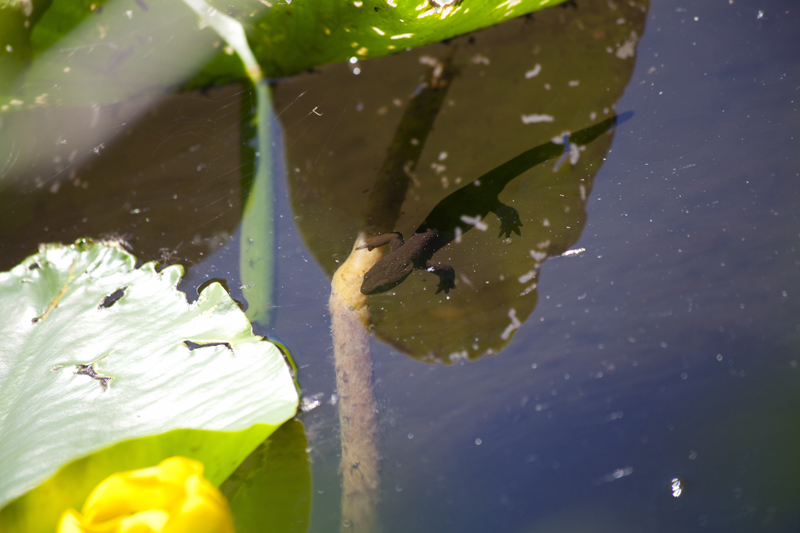
| Salamander larva, most likely long-toed salamander (Ambystoma macrodactylum). |
 |
| Dead dragonfly, another one with black abdomen and greenish eyes. Again, species unknown to me and not enough time to research what species it might be. I saw a lot of dragonflies this year with this coloration. |
 |
| Cascades frog. |
 |
| Cascades frog tadpole. |
 |
| Lots of Cascades frog tadpoles. I saw a lot of tadpoles this year which would seem to indicate to me that Cascades frog populations in the areas that I visited are probably pretty healthy and reproducing. |
7/4/15 Sorenson Creek:
Went up Gilligan Cr Road to some ponds up on upper Sorenson
Creek. Heavy sweat soaked through pants and chafed for most of the day, from
about 10 o’clock onward. Saw Targra (rough skinned newts) at lower pond.
Blister on foot at base of toe.
 |
| A mayfly, Order Ephemeroptera. Again I don't know the species. I know it is a mayfly because the wings are held upright. I have read somewhere that mayflies have a more primitive body plan and can't hold their wings flat against the body like many other flying insects. Many mayflies also have three tail filaments (the enlongations at the back of the abdomen) while this one apparently only has two, though the third might be reduced and nearly invisible. There was a big mayfly hatch going on when I visited this pond. Quite often fish will key into feeding on a particular species of aquatic insect that is hatching and feed on them almost exclusively. This is why many people who fly fish are quite knowledgeable about aquatic insects. They need to know what a particular species is so they can "match the hatch". I was never a very accomplished fly fisherman. There were no fish in this particular pond, at least not when I was there. |
 |
| Damselfly, species unknown to me. |
 |
| Another black dragonfly with green eyes, species unknown to me. |
 |
| Rough-skinned newt (Taricha granulosa). Rough-skinned newts are 10 to 100 times more poisonous than black widow spiders. You pretty much have to eat them to get killed by them though. So don't eat them (there are several recorded instances of people who did, mostly male with alcohol involved). Interestingly garter snakes (Thamnopsis spp.) can eat them and survive. In fact, garter snakes prey on rough-skinned newts. Studies have shown that, in response to predation, rough-skinned newts get more toxic and the snakes that prey on them, in turn, develop more resistance to the toxin. |
 |
| View of the bottom (ventral) surface of a rough-skinned newt. Their dorsal surface is usually a muddy brown while the ventral surface is usually a bright yellow-orange. Quite often bright colors in amphibians signifies toxicity. |
 |
| Closer view of a rough-skinned newt. This photo is probably not big enough to show the rough, bumpy skin texture. Another interesting thing about rough-skinned newts is that in wetlands where they are found the amphibian diversity is often quite low. I don't know if this is because they prey on other amphibians or outcompete them or both or for some other reason. This particular pond was loaded with rough-skinned newts and I didn't see any other amphibians. Of course the pond edges were so brushy that I couldn't see very well either. |
 |
| Snag near Haystack Mountain. |
7/11/15 Green Mountain:
Had planned to go into Horse Lake this weekend. Weather on
Friday night and early Saturday. Decided to go up Green Mountain and scout take
off point to go into Horse Lake and survey the little pond by the trail on the
way back. Thunder and lightning Friday night and still some rumbles just as I
hit the meadows on Green Mountain. Brush very wet. Got up to point where trail
takes off to go across Green Mountain below lookout but at this point basically
in a cloud, visibility at about 30 feet. Turned back and had lunch just above
pond by trail. Some pretty good rain showers started so stayed beneath trees
for a bit. Met quite a few parties of people going in. Saw most of them
hustling on the way out in the showers while I sat beneath the trees. Many
didn’t have rain gear. Surveyed pond and got hit by several more showers. Saw
Cascades frogs and long-toed salamanders.
 |
| Cascades frog. |
 |
| Adult long-toed salamander (Ambystoma macrodactylum). Quite often it is hard to tell Northwestern salamander (A. gracile) and long-toed salamander larvae apart without capturing them and observing them closely which I am almost never able to do. Metamorphosed adults with a yellow or greenish-yellow dorsal stripe like this one make I.D. much easier. |
7/18/15 Horse Lake and Vicinity:
Had planned to go into Downey and Pilot Lakes this weekend,
Friday through Sunday but had memorial services on Saturday. Took Monday off
and went into Horse Lake instead. Very hot. Forecast predicted temperatures in
the mountains in high 70’s but thermometer indicated high 80’s in shade and
mid-90’s in sun. Lots up and down. 800 feet or so down into first ponds, one of
which appeared to be a SAIL. Lots of side hill on steep ground through
avalanche tracks and steep, slick meadows where had to use all fours quite a
bit. Up about 500 feet to another pond. Then more sidehill through slick steep
meadow, rock slide, side hill through steep forest. Hit flat in avalanche track
and identified saddle that I went through in 1995. Looked like thunder clouds
possibly brewing over Dome Peak, Leconte, Sentinal Peak to the east and getting
a little concerned. Wanted to be at Horse Lake by end of day because it is
quite a bit lower and less exposed to lightning than my position at that point.
Time was about 1700 (5:00 p.m.). Might be close if I ran into any troubles getting to
saddle to get down to lake. Travel very slow over steep side-hills. Pretty easy
travel to meadows below saddle but very steep, rocky ridge just before saddle.
Tried to go below it through steep, slick meadow and got cliffed out. Decided
to go a little higher through what appeared to be a gap in rocky ridge. Just
barely doable but managed to get through sketchy spot in steep forest, then
meadow. Reached saddle and recognized it as the one I went through in ’95.
Steep down but doable, heather first, then talus. Very slow going picking route
through rocks. Much of rock was loose and feet were burning and very sore at
this point from all of the side hill walking. Made it to lake at about 2000 (8:00 p.m.) with just enough time to set up tent, cook dinner and eat before dark. Up till
about 2230 rewriting notes taken that day. Next day up early, about 0545.
Breakfast. Surveyed around lake and caught Cascades frogs for chytrid fungus
samples. Suspicions confirmed that small pond on south side of lake probably
SAIL (snow avalanche impact landform). Also noticed a large mound on northeast
side of lake facing avalanche track on east side of lake and believe this probably also a SAIL. Deepest
part of lake is right there between the mound and the avalanche track. Only had
about half an hour to fish. Hooked one fish, good sized, probably 14 to 15
inches long and a pound or so. Fish fought vigorously and was able to drag line
across rock, breaking it. No more bites. Started out of lake at 10:00 a.m.
Reverse process of up and down and steep, slick side hill. Reached trail at
about 1600. Reached rig at about 1730. Pants soaked through from sweat (it
was 102 degrees F in Marblemount that day) and inside of thighs chafed raw.
Bottoms of feet burning from all of the side hill walking. Nail of left pinky
toe loose and bruised from side hill walking (fell off later). Might be a better
high route into Horse Lake. Trail register indicated several parties were going
to climb Mt. Misch and Buckindy, both of which are beyond saddle where I
dropped down into Horse Lake. Old trail that still sees some use continues
along side hill higher on ridge than ponds I dropped into. Didn’t see anything
like a trail at saddle where I dropped into Horse Lake. Didn’t have time to
investigate. I knew the route I took would work, it would just be hard. Looking
into an easier route may have resulted in having to scrap trip. Black flies
bad.
 |
| Sentinel Peak at the head of the South Fork Cascade River. The basin in the foreground is actually near the headwaters of Downey Creek on the Suiattle River. It might not be obvious from this photo but Sentinel Peak is actually behind a ridge forming the headwaters of Downey Creek. |
 |
| Pond along my route. I think this might be a SAIL (Snow Avalanche Impact Landform) created when avalanches from the ridge above hit a relatively flat area of fine soil with enough force to excavate a crater. The pond occupies the crater. |
 |
| Dragonfly, another species unknown to me. |
 |
| Another view of the previously pictured pond 180 degrees from the previous photo. Note the large mound at the far end of the pond. This is all fine material and was likely excavated from the pond area if this is, in fact, a SAIL. |
 |
| Aquatic invertebrate. Species unknown to me. Probably a predaceous diving beetle larva. I saw these in several ponds this year. I had seen them before and they were vaguely familiar but I couldn't place what they were. I initially wrote down in my field notes that they were fairy shrimp but there was a nagging feeling that they were not. For this post I made the time to do a little research and now believe that these are beetle larvae. |
 |
| Dome Peak. |
 |
| Mount Chaval. Mount Chaval is also visible from Highway 20 as one looks up the Illabot Creek drainage. |
 |
| Small pond on south side of Horse Lake. Horse Lake is just out of view on the left side of the frame. This pond is also probably formed by a SAIL. It is at the bottom of an avalanche track. Note the large berm on its left (north) side. |
 |
| Mount Buckindy, evening from Horse Lake. |
 |
| Mount Buckindy from pond on south side of Horse Lake with large berm in foreground. |
 |
| Horse Lake from berm on the south side pond. Note another large berm near center frame. This part of Horse Lake is also at the bottom of an avalanche track. |
 |
| More Cascades frog tadpoles. |
 |
| Close up of large berm in Horse Lake. |
 |
| Mount Buckindy from Horse Lake, mid-morning. |
 |
| Horse Lake from a higher vantage point. The large berm is to the left of center frame. Note that the water is much deeper in front of the berm. It is likely that this is a SAIL also. |
 |
| Horse Lake and Mount Buckindy. |
 |
| Mount Buckindy with Horse Lake in foreground from ridgetop. |
 |
| Mount Buckindy and foreground ridges from Green Mountain. |
 |
| Vertical frame of previous photo. |
7/25/15 Swamp Creek:
Had planned trip into Sulphur Mountain Lake and vicinity
this weekend but heavy clouds and rain. Needed rain. Saturday was supposed to
be less rainy so went into lake on Swamp Creek on Granite Creek/Ruby Creek/Ross
Lake. Had been into this one in
2002 or 2003 in early October and wanted to go back in hopes of making better
observations of amphibians and maybe catch some fish which I was unable to do
on the previous trip. Way trail into this lake but couldn’t find it at Hwy 20
so just started up hill. Thought I picked it up several times but each time,
trail petered out like game trail. Thought I remember a better trail on earlier
trip. Picked up trail about halfway up and it was well beaten. Got into lake at
about 15:00. Fish surfacing all over the place and many of them were pretty
big. Holes also opened in clouds showing good views of Easy Pass, Mount Hardy
and The Golden Horn. Torn between taking pics and fishing. Decided on pics,
figuring the fishing would probably still be good. Turned out fishing wasn’t
that good. Few bites. Finally got nice one on, a big westslope cutthroat, but
as I heaved it up on bank, it fell off. A mad scramble and I had it in my hands
but it wriggled free and got away. Continued around lake and finally managed to
catch another fish. Didn’t see any amphibians. Saw what were probably moose
tracks. Started out at about 17:00. Lost trail in large area of wind thrown
trees. Just continued down without trying to stay on trail and got back to rig
at about 18:30.
 |
| Fisher Peak, Easy Pass, Ragged Ridge Area from access into Swamp Creek Lake. |
 |
| Fisher Peak, Easy Pass, Ragged Ridge Area from access into Swamp Creek Lake. |
 |
| Golden Horn from Swamp Creek Lake, fairly recent burn in foreground. |
 |
| Mount Hardy (left) and Golden Horn from Swamp Creek Lake. |
 |
| Golden Horn from Swamp Creek Lake. |
 |
| Golden Horn from Swamp Creek Lake. |
 |
| Mount Hardy from Swamp Creek Lake. |
 |
| Possible moose track at Swamp Creek Lake. The notebook next to the track is over seven inches long. |
 |
| Westslope cutthroat (Oncorhynchus clarki lewisi) from Swamp Creek Lake. |
7/31/15 Sulphur Creek Ponds:
MMT Salmon BBQ Sunday so took Friday
off and did trip into ponds on Sulphur Creek, Suiattle River on Friday and Saturday so could be back on Sunday. Distance of about
4 miles took about 7 hours to travel. Very hot, in the high ‘90’s
low 100’s. Creek took out trail at about 1 mile in. Remaining half mile or so
of trail hard to follow. Then bushwhacked through timber. Nightmare. Older old
growth stand exhibits gap dynamic principle well. Large old tree falls down,
leaving an opening that is filled by small trees and brush. Had to navigate
mazes of deadfalls, some of which were 5 to 6 feet or more in diameter, often
choked with brush-vine maple, red-osier dogwood, devil’s club, salmonberry.
Large logs, depending on how they were laying, created obstacles that, if
lucky, I could crawl under. More often than not, had to crawl over, holding on
by tips of fingers and fall/jump off far side or go around, usually requiring
going uphill or downhill through thick brush several hundred feet in order to
get around log. Footing quite often unstable, wood crumbled underfoot or
stepped in moss covered holes. Seemed like lots of rotten wood crumbled because
it was so dry. Lots of crawling over or under logs or through brush and just
plain pushing through brush. Every move resisted by brush for much of the trip
off trail. Picked up lots of devil’s club and salmonberry thorns. Brush often
combined with crawling over or under giant logs or while losing footing in
unstable ground or rotting logs. Also ended up pushing through lots of brush
created by crowns of deadfall trees. Several times ended up in sort of pitfall
traps where rotten log failed or stepped in hole and ended up stuck in hole at
awkward position overbalanced by pack and then had to slowly flounder out.
Tweaked shoulder by pushing vine maple out of way at awkward angle-did this
several times-also tweaked it catching myself while falling. Wrists and
forearms covered with scratches and filled with devil’s club, salmonberry and
black swamp gooseberry thorns. Devil’s club thorns often break off and stick in
pants where they scratch with every step-this is still better than having them
directly in legs. Shins bruised in multiple places. Inside of thighs chafed
from pants wet with creek water and then sweat. Sweaty back coated with an itchy
layer of needles from small brushy trees growing in understory, mostly hemlock and
silver fir, Got in creek at avalanche tracks and continued up. Thick brush
between Sulphur Creek and ponds. This brush had stinging nettles growing
through it. Stung multiple times on hands and face. Ponds very nice. Don’t know
what formed them-SAIL, or buried ice lenses melting? Pretty good fishing.
Caught rainbow trout. Cascades frogs at ponds, sampled 5 for chytrid fungus.
Cool view of Dome Peak from ponds.
 |
| An example of the forest I walked though up Sulphur Creek. The devil's club (Oplopanax horridus) (seen in the foreground) was abundant as was salmonberry (Rubus spectabilis), vine maple (Acer circinatum) and red-osier dogwood (Cornus stolonifera) all of which helped make for thoroughly miserable walking. |
 |
| Me in front of some typical obstacles, salmonberry and devil's club brush in the foreground. The log behind me is a 5-6 foot diameter Douglas-fir windfall. What is not shown is another windfall of the same size just behind this one and the maze of limbs and brush I had to crawl and drag my pack through to get past this spot. This is a typical situation. The large windfalls were often too large or in a position to simply climb over so I either had to figure out a way to crawl under them or walk several hundred feet, through thick brush, around them. The temperature was in the high '90's. |
 |
| Sulphur Creek. I walked up Sulphur Creek for about half the distance. This was a little easier than going through the timber and the water, which was quite cold, was a nice contrast to the heat of the day. There were several spots in the creek that were a little dicey to get through, carrying a heavy pack though swift currents over slick rocks. It doesn't look like it from this photo but the hole at center frame is at least ten feet deep. The creek was at a low enough gradient at this point to make it wadeable. A little farther downstream I could have waded across in certain areas but my options would have been limited. |
 |
| Thick brush in an avalanche track, salmonberry, vine maple, red osier dogwood, tag alder (Alnus sinuata). It isn't obvious from this photo but this brush was laced through with stinging nettles (Urtica dioica) and I lost track of the times I got stung on exposed skin, mostly my hands and face. As I recall, there was also quite a bit of black swamp gooseberry (Ribes lacustre) full of thin, painful thorns that break off in one's hand if you grab it, which is often unavoidable. Large swathes of the upper part of the valley of Sulphur Creek were like this. I avoided a lot of it by wading up the creek. |
 |
| Windfall patch. This is some smaller timber in the upper part of the valley, probably grown back after an avalanche 100 years ago or so. A windstorm (probably) knocked down about half the stand. This created a large, deep, brushy maze and puzzle. It was fairly easy going as long as I could stay on top of a log but quite often I would go from one log to another and wind up at a dead end on a log that led to an impenetrable tangle of logs and or brush or end in a hole in the log pile ten feet deep. When this happened, I would have to backtrack, choosing the right logs to walk on in order to get around the dead end. Sometimes this just led to another dead end. |
 |
| More windfall area. |
 |
| More brush. Most of the brush was vine maple and red-osier dogwood, in my book two of the worst species to have to get through. Tag alder is bad but it doesn't hold a candle to these two species. This brush was so thick it resisted my every move and my back acted like a big sail, or more accurately, sea anchor, catching everything I was moving through and making movement that much more difficult. Again I was stung multiple times by stinging nettles and my hands filled with thorns of several species including black swamp gooseberry. |
 |
| The ponds at last. |
 |
| I think some or all of these ponds may be a SAIL or individual SAIL's within the same land form. This area is at the bottom of a very large avalanche track many thousands of feet high. Some avalanches in this area actually cross Sulphur Creek and run a little way up the valley wall on the opposite side of the valley. |
 |
| A large berm on the south side of the pond pictured above. It is on the right side of the photo above and it is about 20 feet high. |
 |
| Dome Peak from ponds. |
 |
| Cascades frog. |
 |
| Cascades frog. This is one I captured to take a chytrid fungus sample. |
 |
| A pond a little lower in the landform. The berm of the pond pictured above is just to the left of center frame. My tent is just to the left of center frame below the berm. There is another pond hidden from view by the berm at the right side of the frame and there is a large pond, the largest of this group about 100 feet behind the camera. By the time this picture was taken the temperature had cooled of a bit into the mid to high 90's F. |
 |
| Dome Peak side lit in late afternoon. |
 |
| Dome Peak at dusk. |
 |
| Dome Peak at dusk. |
 |
| Dome Peak from upper pond at sunrise. There are no clouds in the sky. The light lines visible are actually rays of sunlight shining from behind Dome Peak or another nearby ridge or mountain and the dark lines are shadows cast by Dome Peak or nearby ridges. I don't recall ever seeing anything like this before. You have to be in the exact right place at the right time of year under the right conditions to get this effect I think. |
 |
| About ten minutes after the previous two photos. |
 |
| The lower, largest pond, looking at the large berm on its south side. |
 |
| The lower, largest pond looking from the inlet side towards the outlet. The berm on the south side is on the left side of the frame and there is an avalanche track on the right side of the frame. |
 |
| Some fish I caught in Sulphur Creek on the way out. I caught these to bring home for Sacha and the kids. The lower, biggest, fish looked like a purebred westslope cutthroat (Oncorhynchus clarki lewisi), the middle fish had characteristics of both westslope cutthroat and rainbow trout (O. mykiss) and the top fish looked like a purebred rainbow trout. I suspect the genetics would tell a different tale. I have done work in other streams where there were interbreeding populations of westslopes and rainbows and what the fish looked like wasn't always a good predictor of what genes it carried. |


No comments:
Post a Comment